A Hackathon and Ideathon for Sustainable Africa
INFORMATION HAVE BEEN UPDATED DUE TO COVID-19 OUTBREAK
The IST-Africa 2020 conference, supported by the European Commission (EC) and the African Union Commission (AUC), addresses a series of societal challenges.
The Kampala INSPIRE Hackathon 2020 is a contribution to the joint efforts to solve these challenges. The hackathon addresses some of the key topics identified by the IST-Africa conference, such as agriculture, environmental sustainability, collaborative open innovation and ICT-enabled entrepreneurship.
The Kampala INSPIRE Hackathon 2020 is one of the satellite INSPIRE hackathons. The hackathon is organised in the frame of the IST Africa 2020 Conference. The hackathon is a collaborative event organised by Plan4all, Club of Ossiach associations, GODAN, FAO, IST-Africa Conference, Makerere University, AfriGEO, RCMRD and EU projects including EO4Agri, STARGATE, RDA Europe 4.0, SIEUSOIL, DEMETER, SmartAgriHubs, NextGEOSS, EUXDAT, PoliVisu and AFarCloud.
GOAL
The goal of the Kampala INSPIRE Hackathon 2020 is to continue to build and strengthen relationships between several EU projects and African communities that started in 2019 with the Nairobi INSPIRE hackathon. This was one of our most successful hackathons with more than 200 participants representing 26 African countries. The INSPIRE hackathons are not a competition, rather the main focus is building relationships, making rapid developments, and collecting ideas for future research and innovation.
DATES
The hackathon starts on March 2020 by creating hackathon teams addressing pre-defined challenges. The hackathon will run as a fully virtual event and the final phase is on 6th May 2020 between 12 PM and 15 PM CEST where the hackathon results will be presented remotely.
VENUE
The hackathon consists of the following phases and components:
- a virtual period: The teams will work virtually led by the team mentors. Membership and participation in this part is open to all. There will be educational webinars during the virtual hackathon to facilitate the progress/collaboration.
- a series of webinars covering topics relevant to the challenges, information about the challenges and the INSPIRE hackathon itself
on site hackathon (attendance optional) The University of Makerere in Kampala is hosting 2 days hackathon (4 – 5 May) where the teams can continue the work done in the virtual period.a workshop (attendance optional for team members/participants) which is the closing event of the hackathon where the results of the hackathon will be presented. The workshop will take place in Venue TBD, Kampala. For more details, please visit the IST Africa website. - final virtual presentations of results
TEAMS & MENTORS
The Kampala INSPIRE Hackathon 2020 is organised using an unconventional approach, tailored to cater for cross-continental collaboration.
The hackathon starts with a set of predefined challenges. Each project has a mentor (see the list of projects and mentors below). The participants of the hackathon can choose to work on any of the predefined projects. In this way, teams will be built to collaborate on the projects.
The mentors will organise the work and are responsible for the communication in the project teams and will act as team leaders.
The projects and their mentors for the Kampala INSPIRE Hackathon 2020 include:
| CHALLENGE | PROJECT TITLE & DESCRIPTION | MENTOR |
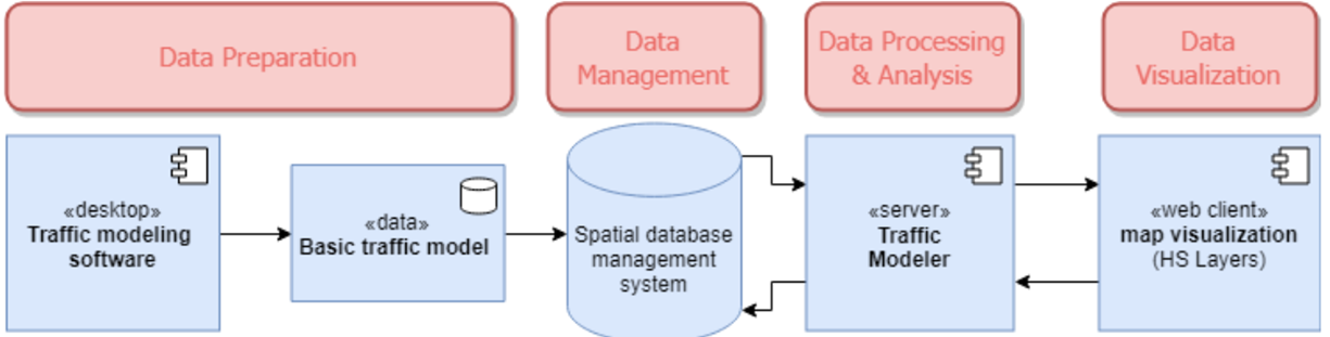
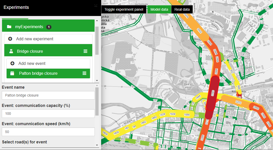
| 1 | Transportation related aspects of Urban Planning - use case of Kampala
Transport industry is a point of concern in the Kampala region due to lack of real time information on traffic flows, traffic police officers fail to redirect traffic in order to avoid traffic jams, and travellers can not plan their journeys in advance in real time to avoid congested routes.
The aim is to ideate a concept on addressing traffic nodes, perform GIS routing and also apply the traffic modeller to test various traffic scenarios at given nodes in Kampala region and the outcomes of this challenge are:
- Analysis of the current state of traffic
- Review and use of tools (traffic modeller + routing)
- Concepts on how to utilize geospatial IT solutions on traffic management | Stephen Kalyesubula |
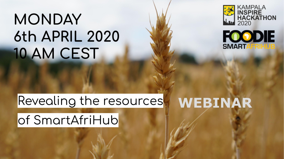
| 2 | SmartAfriHub
The challenge 2 invites user groups to a dialogue and to explore, experiment and reflect the features and applications of the Digital Innovation Hub. The two entwined challenges of the team 2 are:
Develop tactics on how communities of practices of agriculture and digital technologies could "seek, sense and share" needs, problems and knowledge at SmartAfriHub and deliver value to community members, farmers and society of Uganda. Such agriculture community of practice is for example RUFORUM (www.ruforum.org), and digital community of practice is Plan4all, (www.plan4all.eu)
Explore and test the available SmartAfriHub applications with the help of a mentor. For example one can develop a map of your own with one or several layers. One can also integrate agriculture, Earth Observation or other open data on the map layer. | Jiri Kvapil |
| 3 | Open Land Use for Africa (OLU4Africa)
The main goal of the challenge is to do research on available data sources, that could be used in defining the land use in Africa, especially in the East Africa region. That could be data about land cover, protected areas, urban areas, topographic geographic databases, transport infrastructure, points of interest, crowdsourced data etc. After the research is done the algorithm on how to define land use type based on the collected data will be created. As a result ideally the land use map of Africa will be created. As an additional extra tasks could be seen integrating the data into open-source solution SensLog (by implementing appropriate SensLogConnector), as well as extracting some important information (for example, about land cover) from satellite imagery. | Dmitrij Kozuch |
| 4 | Desert Locust
East Africa has been hit by serious outbreaks for example Fall of Army Worm, Desert Locusts. Previously, the UN warned that an imminent second hatch of the desert locusts could threaten the food security of 25 million people across the region. Soffer, East Africa is losing a lot of Billions in controlling their spread,, a lot of farmers have been affected by this wave, revenues and export earnings dropped, governments have spent a lot of money in this struggle. The appearance of the locusts follows a period of extreme weather, including devastating floods, that have further threatened the food supply. The situation, however, remains most serious in Uganda, Kenya, Ethiopia and Somalia amid evidence that aerial spraying of pesticides against the swarms has so far had very limited impact. However, there is worry among the locals with fears of the danger the pesticides would impose to human life, animal life as well as soil biodiversity.
As a result, innovative solutions that impose a limited or no danger to plant species, human and animal life as well as that protect soil biodiversity are needed in order to control the spread and breeding of locusts. We invite innovative solutions for early warnings of emergence outbreaks as well as solutions for controlling the breeding and spread of such major out breaks while preserving human, animal and soil life. | Paul Kasoma |
| 5 | IoT Technologies for Africa
The idea of this challenge is to research on available data sources, used formats and standards, data sets suitable for further processing in the region of Kampala. Suitable data sources can be integrated into open-source solution SensLog by implementing appropriate SensLogConnector. | Michal Kepka |
| 6 | Climate Change Trends for Africa
This challenge for Kampala INSPIRE Hackathon is to search for trends in climatic data because future climatic conditions can be inspected and potentially forecasted based on temporal trends in climatic data.
Therefore we plan to provide a proof of concept scenario in which a user enters coordinates (i.e. choose a locality), he/she will get information about several climatic variables (e. g. Last spring / First fall frost date, Annual/Seasonal Evapotranspiration and precipitation, Soil temperature, Solar radiation, etc.) and their evolvement in time. The initial visualization can be perceived as a graph, where a trend of such a variable is shown. Moreover we would like to incorporate information about the uncertainty of such a variable in the graph as well, in order to capture the credibility of the used data. | Pavel Hajek |
| 7 | EO4FoodSecurity
EO4FoodSecurity Challenge will be focused on two topics. First will be focused on analysis, how EO can help in developing countries the problems of food security. Second part will be focused on capacity building. It will be closely related to SmartAfriHub. The partcipant will have chance to test different tools and algorithms. There is prepared number of tools, which will be freely available and also data on the borders between Uganda, Kenya and Tanzania around Victoria lake. | Karel Charvat |
| 8 | Text mining and metadata
The goal of this challange is to discover resources of Open Geospatial Data in Africa. The technology of Crawler will give possibility to search for sources of data on different Web Pages in Africa. There will be also developed user interface, which will support controlling of accessibility of this data and visualisation or catalogisation of such data. | Karel Charvat |
| 9 | Ethical and legal aspects of open data affecting farmers
Open Data offers a great potential for innovations from which the agricultural sector can benefit decisively due to a wide range of possibilities for further use. However there are many inter-linked issues in the whole data value chain that affect the ability of farmers, especially the poorest and most vulnerable, to access, use and harness the benefits of data and data-driven technologies. There are technical challenges and ethical and legal challenges as well. Of all these challenges, the ethical and legal aspects related to accessing and using data by the farmers and sharing farmers’ data have been less explored. We aim to identify gaps and highlight the often-complex legal issues related to open data in the areas of law(eg.data ownership, data rights) policies, codes of conduct, data protection, intellectual property rights, licensing contracts and personal privacy. | Foteini Zampati |
| 10 | Interchangeable map compositions in support of collaborative spatial intelligence
This challenge seeks to further develop a proposed standard format for interchangeable map compositions building on the results of several previous hackathons. A map composition standard opens the door to another interesting innovation, namely an application that is to maps what Google Docs is to text documents.
The challenge will work in parallel with evaluating and extending the current draft specification for JSON map compositions as well as build a working prototype of a web based collaborative map builder application. It will be also be possible to share the map compositions with desktop platforms (QGIS) as well as on various social media platforms | Raitis Berzins, Runar Bergheim, Karel Charvat, Dmitrij Kozuch, Jan Vrobel and Irena Koskova |
CAPACITY BUILDING
An important component of the INSPIRE hackathon concept is the capacity building activities. It is provided in webinars organized by each of the challenges. In addition to a short introduction to the INSPIRE hackathon concept and the specific challenge, experts are invited to speak about topics covered within the challenge. This way transfer of knowledge (often across disciplines) go side by side with efficient management of the challenge work. The webinars will be announced within a couple of weeks after the hackathon is kicked-off.
TIMELINE
- March 2020 – start of the hackathon, registration opens
- 1st April – 9th April – a series of webinars introducing the teams and their progress. There are educational elements in these webinars.
On site hackathon at University of Makerere, Kampala, Uganda1-7 May 2020 – preparing presentations for the workshop in Kampala - 6 May 2020 – remote presentation of the hackathon results
REGISTRATION
In order to participate in the hackathon, please REGISTER HERE
You can join the teams mentioned above at any time between now and May 2020. The registration is open to anyone from anywhere in the world as the hackathon is done virtually.
In case you will participate at the hackathon workshop within IST-Africa in Kampala (8 May 2020), you need to register for the IST-Africa Conference itself. Please notice that participation in onsite phase and IST-Africa workshop, where the results will be presented, is optional.
FEE
Participating in the Kampala INSPIRE hackathon is free of charge.