FINAL REPORT ON CHALLENGE #14: Irrigation management
Name of mentor(s): Jakub Fuska
Number of participants: 3
FINAL REPORT_challenge14 [PDF, 0,7MB]
INTRODUCTION
- Background of the challenge
- Full explanation of the challenge defining the scope of the effort.
The experiment was focused on helping farmers to estimate the amount of water that is currently stored in irrigation water reservoirs such as small lakes or dams. The information of the available water amount is crucial for the farmers so they can make the decisions on irrigation planning not just in accordance to crop requirements, but also to incorporate the available amount of water for irrigation purposes.
Usually the water reservoirs have some kind of water level measurement – for example water level gauge. But the amount of stored water at a given water level is slowly decreasing as the result of reservoir siltation that occurs on every lake or dam as the result of erosion in watersheds.
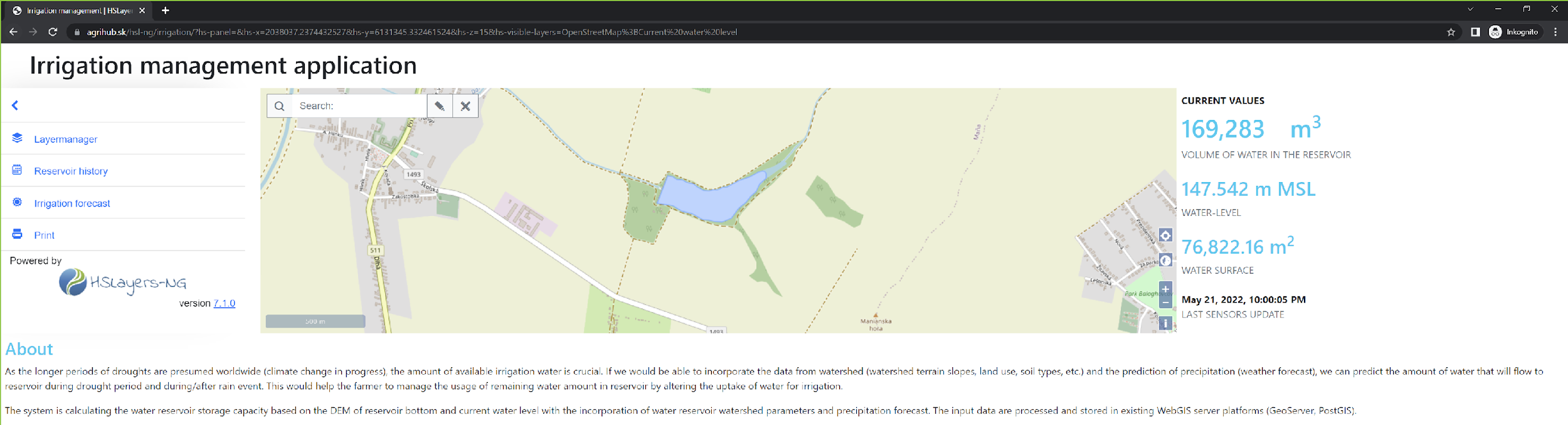
The goal of project is to create a simple tool that would continuously measure the water level and then calculate the water storage at a given moment. To get the information, we are using the ultrasonic sensor that surveys the water level and then we use this information within the calculation, that is based on the digital elevation model of reservoir bottom. This model is created from the sonar and GNSS survey to obtain the most current data of the bottom shape for most accurate volume calculations.
METHODOLOGY
The methodology of the report contains the sections that describe the progress and results achieved for the entire challenge.
The team consists of the following members: Peter Piesecký, Jan Macura and Juraj Modranský, the mentor is Jakub Fuska. Members are working in various fields focusing on GIS, geoinformatics and landscape planning. During the project we established the cooperation with the company plantcontrol.io and the discussions were also made with the SensLog developers about possible future cooperation.
The experiment is built on the idea of the continuous ultrasonic measurement of water level with the storing of this data that is processed by server with the use of a water reservoir digital elevation model of the bottom to provide the water depth map for calculating water volume and water surface area at given water level elevation. Then the data is displayed on simple web page also with the data of presumed recharge of water in forthcoming 7 days in accordance to simple hydrological model that takes into account the land use in watershed and also weather forecast (fetched from openweathermap.org) – this will help the end user – mostly farmers or water reservoir and irrigation operators to make the better decision on irrigation planning.
The data used for this challenge are following:
- DEM of bottom of reservoir in Maňa, Nové Zámky District, Slovakia (from survey made by Slovak University of Agriculture in 2015)
- DEM of the reservoir watershed (from slovak national GIS dataset ZBGIS)
- land use derived from orthophoto map (from Slovak national GIS dataset ZBGIS)
- weather forecast (from openweathermap.org)
- soil moisture sensor data (from company plantcontrol.io)
The equipment used for this challenge is following:
- virtual server (provided by company ATAPEX, hosted on servers of company CONTABO)
- NSE01 NB-IoT Soil Moisture & EC Sensor (sensor provided by plantcontrol.io)
- Experimental prototype of ultrasonic sensor based on ARDUINO platform
The stakeholders are identified as two main groups:
- Farmers who are using the irrigation reservoirs for their own usage
- Operators, owners and providers of the water reservoirs and irrigation infrastructures who can use this tool to optimize the irrigation systems
The upcoming climate change is affecting the water consumption in the various industries, but it is significantly affecting the agricultural sector as irrigation is becoming the necessity for providing crop yields now and in the future. The planning of irrigation is focusing mostly on the crop needs, but it should also consider the currently available and in-near-future available amount of water.
The project has shown that the simple equipment for continuous water level survey and periodical (once in 2-3 years) water reservoir sonar survey in combination with open-source technologies (Linux server, PostGIS database, GeoServer, GRASS GIS, OpenLayers library, openweathermap.org weather forecast, national GIS datasets of terrain morphology and orthophoto maps) can provide the solution for monitoring of water reservoir in the manner of water volume availability.
FINDINGS & CONCLUSION
The development of the system for providing the current information on water level elevation, water volume and water surface area is capable of operation with the quite low prices of sensors (talking about <300 € per water reservoir) with simplicity of data provision with the use of custom-build web page using FOSS technologies.
During the hackathon there was tested also the availability of soil moisture sensors, but it was not used for the hydrological modelling as the team lacked the expert in hydrological modelling, so only simple black-box model was used for modelling the recharge of water reservoir in accordance to the weather forecast and land use in reservoir’s watershed.
Thereseults are promising and as the project is only in the beginning, it is possible to work on the tasks in the future with the focus on improvement of the hydrological modelling, analysis of the weather forecast data and improvement of the result web page to provide more information and higher quality of the outputs.
The webpage that runs the results is available at https://www.agrihub.sk/hsl-ng/irrigation/