
FINAL REPORT ON CHALLENGE #13:
Agro Environmental Services @ Agrihub.sk
Name of mentor(s): Marcela Bindzarova Gergelova, Martin Tuchyna Number of participants: 8 + 26 students from Technical University of Košice
FINAL REPORT Challenge 13 [PDF, 6MB]
INTRODUCTION
- Background of the challenge
Before the the AgriHub Czechoslovakia project1 had started, there was any Geo-ICT platform available in Slovakia. Now, when the project is about to accomplish its mission, this challenge would like to demonstrate how the project helped to improve the situation and what might be the opportunities to sustain the platform and enlarge the community. Challenge has built on top of the Innovation experiment No. 3 Agrihub INSPIRE hackathon 2021 outcomes2.
- Full explanation of the challenge defining the scope of the effort.
Main motivation of the challenge is to provide access and support for spatial data utilization within agro environmental context. This shall provide support for agri-food Geo-ICT community building process, networking, stimulating innovations and knowledge transfer in Slovakia. Lastly, the team addressed the potential of the agrihub.sk platform for future sustainability and improvement.
Challenge has focused on identification of relevant stakeholders and their requirements, investigated available data sources, technologies and supported set of following use cases:
- Cífer Farm
- Students´ work and training
- Agricultural subsidies support
- Predictive analytics in Agriculture
https://docs.google.com/document/d/1faNDf1UQqFg6j18WDdcCIz4Q8y2ebs8X/edit?usp=sharing&oui d=104472217504663040803&rtpof=true&sd=true
Challenge concludes with the identification or the potential and outlook for the further maturation of the agrihub.sk platform and community.
METHODOLOGY
The methodology of the report contains the sections that describe the progress and results achieved for the entire challenge.
- Team description + info about any coordination with other organizations, outside agencies
Wide range of expertise and support has been provided by the experts from public sector bodies (Ministry of environment of the Slovak republic), universities (Technical University of Košice) as well as private sector (farmers’ representatives, companies).
- Technical Background
In order to implement this challenge and underlying use cases, wide range of technical expertise has been utilized:
Technical expertise:
- Data and business analysis
- Data pre & processing (GIS desktop tools, Python scripts)
- Data processing
- Data publication and visualization
- Statistical analyses (GIS desktop tools MS Excel)
- Description of the process of solution
Solution has been developed based on the collaboration of involved experts, following methodology and process definition consequently deployed in challenge implementation with corrections and improvements, where needed.
- Data list
- Copernicus, INSPIRE and other national AsIs geodata
- open data platform provided by the National Agency for Network and Electronic Services
- applications and services provided by Geodetic and Cartographic Institute Bratislava
- EO browser
- Earth explorer USGS
- MeteoBlue API
- European Climate Assessment & Dataset (ECA & D)
- Equipment and technology list
- QGIS
- ArcMap
- Layman
- Micka
- HSlayers-NG
- Digital innovation hub
- MS Excel
- Detailed implementation plan
Challenge has started with the relevant stakeholders’ identification, resulting with interviews with the representatives of farmers, students as well as related added value services providers. Consequently, work on data collection and preparation has started, followed with identification of the user requirements and scoping of use cases.Following activities were focused on use cases implementation in iterative manner and collection of the outcomes and outlook.
- Analysis of needs of stakeholder groups
This was an important part of the challenge implementation, being aware the target users are a critical precondition to define realistic requirements as a base for further use cases design and implementation.
- Use cases
- Use case #1: Cífer farm
- Use case #2: Students´ work and training
- Use case #3: Agricultural subsidy support in Slovakia
- Use case #4: Predictive analytics in Agriculture
Use case #1: Cífer farm
The aim of the challenge team was to collect and prepare datasets to meet the requirements of farms. Cífer Farm was chosen for this purpose as we were able to establish a connection with the open minded representative of this farm.
The use case featured two processing levels: the first was data collected from Cífer Farm, and the second processed the data that were created for Cífer Farm within the challenge. The datasets produced for Cífer Farm are stored in a single location and are available via a desktop QGIS client application as well as from web browser (see Figure.1).
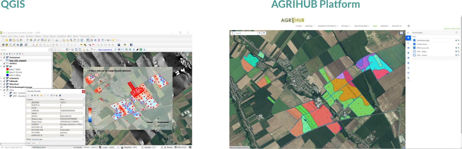
Figure 1. Data from Cífer Farm stored in a single location.
The second level was linked with data processing for the target farm using the EOBrowser platform. This platform provides the user with support in browse, compare, download full resolution image from all data collection for other data analysis. NDVI datasets were prepared for this farm over a set time period (see Figure 2.).
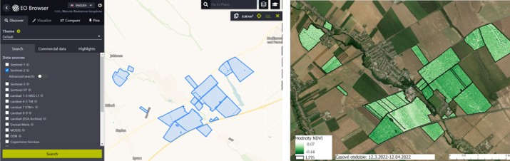
Figure 2. Processing data for Cífer farm using the EOBrowser platform.
Use case #2: Students´ work and training
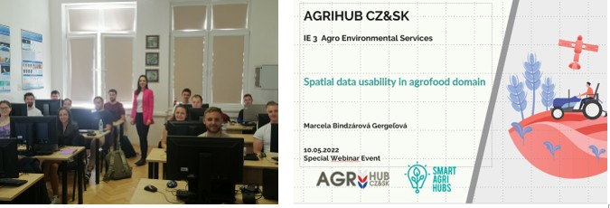
Another use case transferred the approach to the academic environment (see Figure 3.).
- (b)
Figure 3. Academic environment approach: (a) Course for students: Design and realization of GIS, (b) Webinar for students: Spatial data usability in agrofood domain
The use case also had two processing levels; the first of these concerned education, knowledge base transfer and the training program itself, in which students worked on data collection of the most important data sets for farmers. In the first stage, data were collected for three farms (Poľnohospodárske družstvo BEBRAVA, Poľnohospodárske družstvo Melčice – Lieskové, Poľnohospodárske podielnické družstvo Liptovská Teplička). In the second processing stage, we examined the data collection process for data provided for 25 farms (See Table 1).
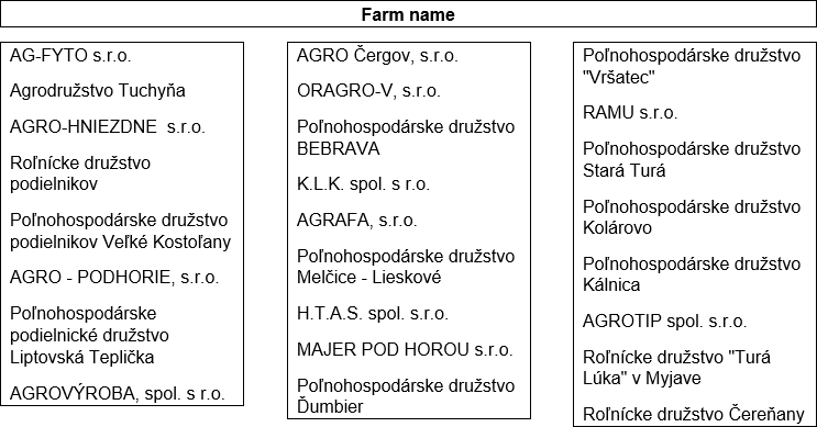
Table 1. List of chosen farms
The task was to present the potential and transfer of knowledge base from the education process into the field of agrosector. Students
presented the possibilities of preparing datasets, which are useful for farmers.
The processing approach was divided into two parts:
- Preparation of input data
- Creation of thematic layers of selected farms
Preparation of input data of selected farm
To obtain primary sources of spatial data, portals of available open data in the conditions of the Slovak Republic and other documents were used, which enabled spatial localization of individual farms according to Table 1. Those groups of datasets were selected which use farmers the most and which will help them in decision-making processes. Specifically, it was a series of these datasets:
- LPIS,
- BPEJ,
- boundary of use,
- cadastral boundary,
- boundary of local administrative units,
Creation of thematic layers of selected farms
Postprocessing was performed using ArcMap tools. It was also a series of other procedural tasks:
- preparation of thematic layers,
- working with geodatabase,
- using of geoprocessing tools for automation of the processing process and geospatial analysis,
- sharing datasets with other users,
- creation of print reports,
The following figure presents an overview of the obtained outputs for the Farmer’s cooperative Čereňany.
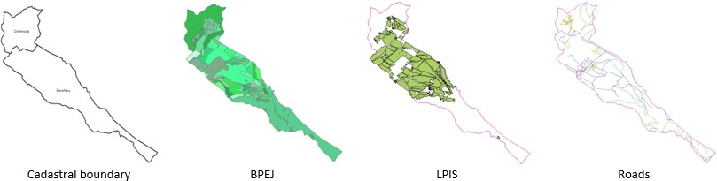
Figure 4. Data collection for the Farmer’s cooperative Čereňany
Final reports were created for each farm on the basis of many types of base maps. These reports were supplemented by other cartographic elements such as the legend, the scale of the map, the north arrow (Figure 5).
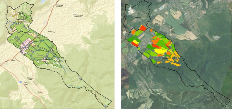
Figure 5. Overview of the final reports for the Farmer’s cooperative Čereňany.
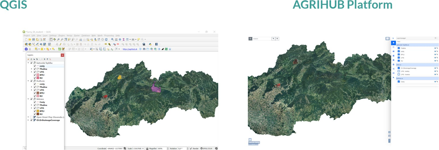
Figure 6. Publishing the Farms data via desktop QGIS and web agrihub.sk interfaces.
Use case #3: Agricultural subsidy support in Slovakia
This usecase intended to increase awareness of end users, when applying for the subsidies support in Slovakia. Manz farmers face significant challenges when applying for subsidies linked with digital literacy as well as limitations that occurred during the Covid pandemic period. With that possible improvement has been investigated in connection to the participation of Slovakia on the EU initiative Fastplaform3 aiming to make farmers’ and other stakeholders’ interaction easier.
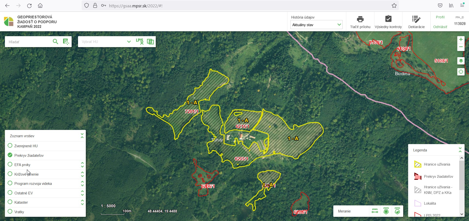
Figure 7. Geospatial part for subsidies requests in Slovakia
Use case #4: Predictive analytics in Agriculture
The last use case was devoted to the topic of Predictive analytics in Agriculture. The challenge applied an innovative experimental approach and involved PhD students. We want to mention this use case because it solved an important issue: design and application of a prediction model for crop yield estimation of selected agro-commodities for strategic supply chain management using large data (Big Data) and machine learning. Models (custom made, WOFOST crop growth simulation model) were tested (see Figure 8).
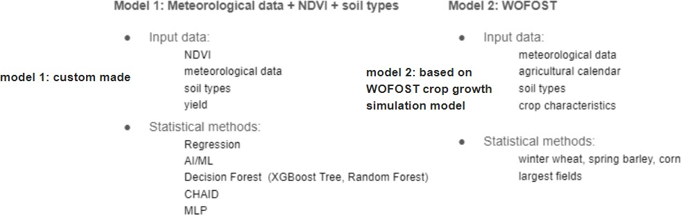
Figure 8. Models under the tests
Following result has been identified:
- These models have not been tested in the conditions of the Slovak Republic yet.
- NDVI in custom models had a significant position.
- Wofost stimulates crop growth over time, from point zero (sowing to harvesting), the conclusions of the test showed that this model is not applicable in our conditions.
- Highlight of this use case was a custom model. The most accurate model turned out to be three inputs of the components Meteorological data + NDVI + soils characteristic (see next Figure 9).
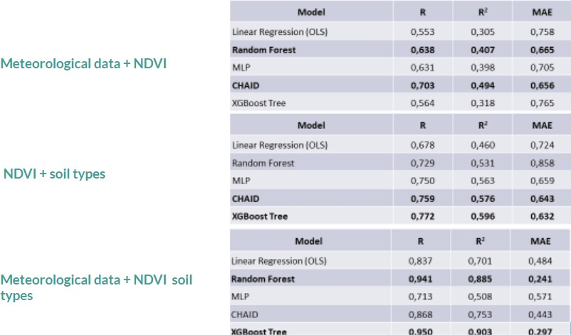
Figure 9. Results under tested models
FINDINGS & CONCLUSION
- Discussion of the results and findings
Outcomes and experience achieved with this challenge helped to initiate discussion about potential and further outlook of the agrihub.sk platform as well as community related agrifood and environment community. It shall be of the joint interest for the whole current project team to sustain the platform and contribute to the further development and enlargement of the relevant stakeholders’ network. There is
significant potential in investment to the platform as current societal challenges calls for innovative solutions with the support from geoict perspective.
- Further improvements
There has been identified set of possible areas for improvements which can be divided to the two main categories:
- Platform
- Maintenance (Plan4all)
- Further technology development (Plan4all+partners)
- Content improvement
- Info content management
- Jobs, Calls, Events, Contacts
- Metadata, data/services, map compositions
- Info content management
- Community
- Further business development maturation
- New projects opportunities
- Networking support
- Organising events