Kampala INSPIRE Hackathon in Numbers

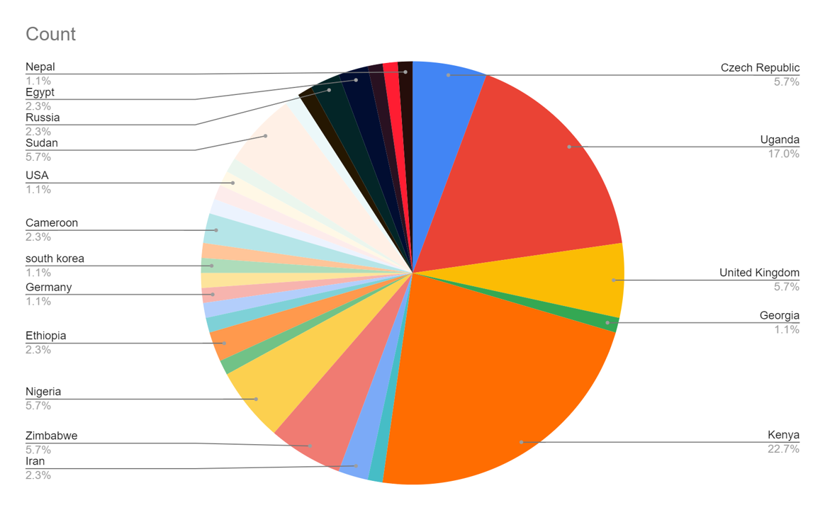
Inspire Hackathon Kampala in Uganda has gathered a total of 200 registered hackers. Despite the unexpected barriers that COVID-19 formed, the interest of African agriculture researchers, practitioners and stakeholders was prominent.

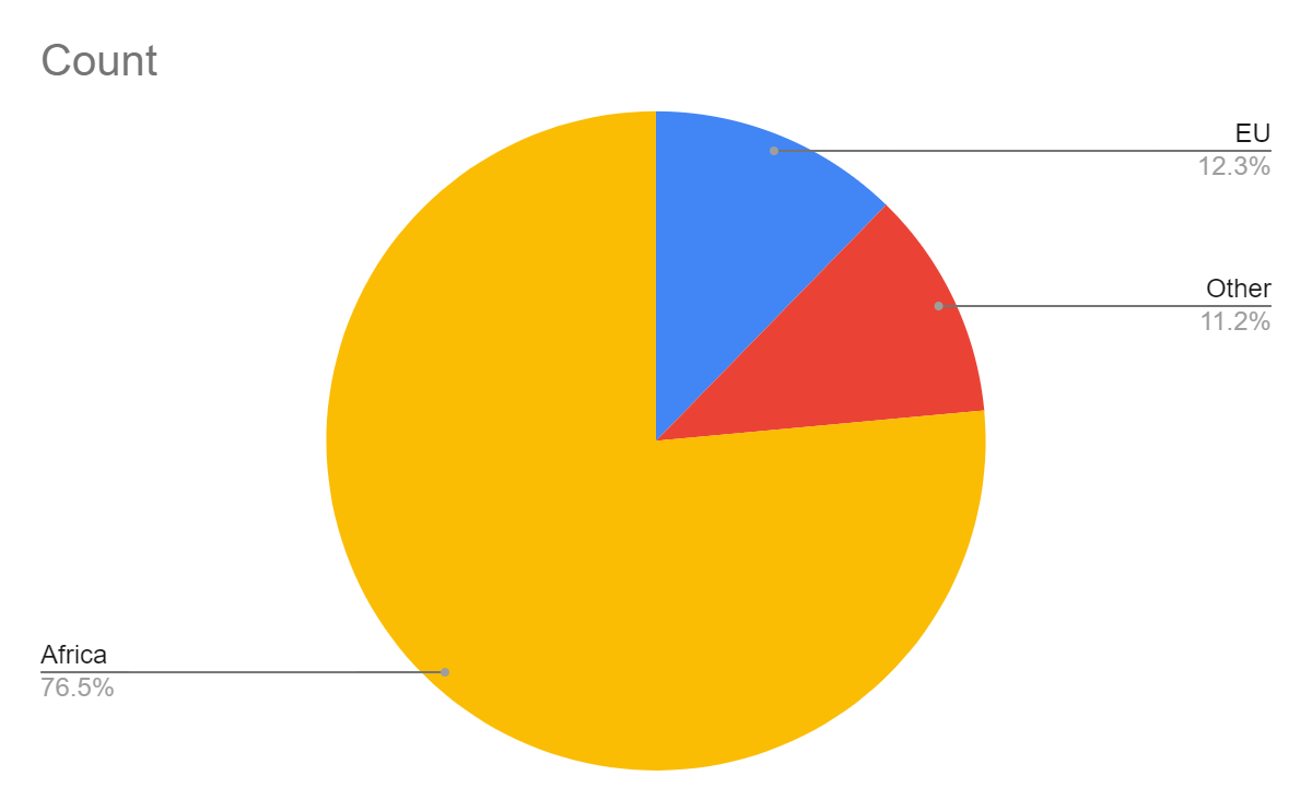
The hackers represent 38 countries world wide:  Africa continent 77 %, Europe 12 % and other countries 11 %.

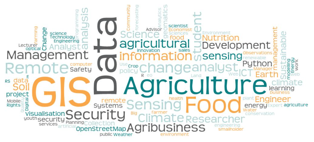
The hackers’ expertise falls into the smart agriculture domain. It encompasses data collection, data analysing and decision support systems.  The GIS – GeoSpatial Information – has a centric role. The community is interested in developing soil health, agri- and food systems, mitigating climate change and to secure food supply.  The goal of sustainability in the means of economics, society and environment is embedded on the hackers DNA.

The hackers’ employers, research institutions, academias, companies and other governmental and policy public bodies contribute smart agricultural research, development and innovation action in order to foster digital transformation in Africa.

The on-going change requires efforts on the capacity building on IT literacy,  investments on emerging technologies that support Agriculture 4.0 strategy, and digital data that is known, open and achievable.

The multi-actor approach is needed when the ambition level for improvement is high:  there is a need to increase production yield, improve soil health, biodiversity, and to provide adequate income for farmers and reduce greenhouse gas emissions.

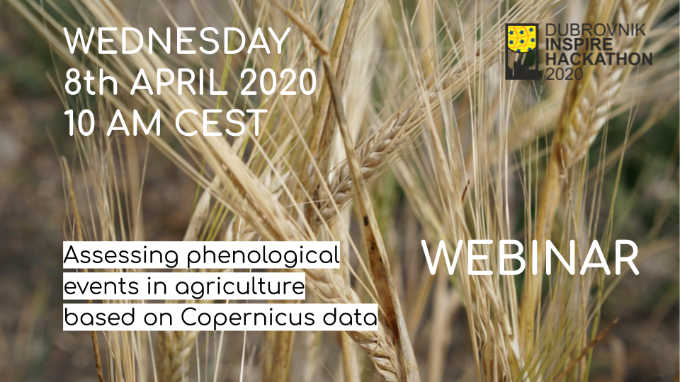
It’s still not too late to become a participant in Kampala INSPIRE Hackathon! Check the guidelines below and do not hesitate to register!

RDA/IGAD Webinar Series: Intelligent Plant Data Linkage Webinar Today!

As part of the Research Data Alliance’s (RDA)/ Agricultural Data Interest Group’s (IGAD) ongoing webinar series, aimed to keep up with cutting edge developments in agricultural data, and encourage the free flow of ideas, the next webinar is set to take place on Thursday, April 16 at 11:00CEST.

The webinar will focus on “Intelligent Plant Data Linkage: A View from History, Philosophy and Social Studies of Science,” and will feature Sabina Leonelli, Professor of Philosophy and History of Science at the University of Exeter and Hugh Williamson, Research Fellow at the University of Exeter.

Interested participants can join at http://fao.adobeconnect.com/ropwj1ofhdg1/


Upcoming Webinar: Assessing phenological events in agriculture based on Copernicus data

Last week, the webinar on Assessing phenological events in agriculture based on Copernicus data was interrupted due to overloaded webinar platform. Fortunately, our presenters are very kind to repeat this webinar for you on Thursday and you are cordially invited!

DURING THIS FREE WEBINAR YOU WILL LEARN:

  • Phenology in agriculture
  • Phenology relevant data (RS/Copernicus data, other sources of data): definition and availability. Radar and optical data
  • New data analysis methods such as deep learning algorithms

What: Monitoring phenology along the growing season on a large scale is crucial for all actors of the agri-food chain (farmers, agri-food industry, insurance companies, public administration and policy makers) but is still challenging. Different possibilities to improve the assessment of agricultural crop phenology can be identified and this webinar we will discuss some ways of addressing these challenges. The complementary use of different sources of time-series data (remote sensing, ground truth data,…etc .), modern algorithms/methods and computing resources to analyse it, allows a near real time (NRT) monitoring of crop phenological events for all actors in the agri-food chain. The use of radar data (S1 and possibly S3 images) could provide valuable information on crop phenology over areas often covered by the clouds. Availability of «new» sources of geo-located data sets (meteorological, dash-cams, etc ..) allows to enlarge ground truth sample to calibrate and validate the proposed algorithms. Deep learning algorithms designed for time-series analysis used on high power computing systems, allows to improve the monitoring of phenological events in agriculture.

Why: Availability of Copernicus data. Processing large amounts of image data such as those provided by Copernicus is a computationally demanding task. Computing capabilities have considerably increased over the last years so as allowing the processing with complex algorithms of these data.

Who (is the webinar for):  Academia & Research, Researchers, students, people interested in time-series datasets and high-dimensional function modelling via deep learning.

If you want to learn more, please register for the livestream HERE!

Thursday’s Webinar on Improving interoperability between methods for sharing in-situ and citizen-sourced data

On Thursday there will be a webinar focused on Improving interoperability between methods for sharing in-situ & citizen-sourced data and you are cordially invited!

DURING THIS FREE WEBINAR YOU WILL LEARN:

  • Approaches for modelling citizen-science data through the OGC SensorThings API
  • Representation and visualisation of resources in the context of existing applications
  • SensLog solution for sensor data, integration of data from different sources

What: Initially, the webinar will introduce the benefits emerging from the utilisation of the OGC SensorThings API, as well as the problems that aims to address in terms of modelling both in-situ and citizen science sources of environmental information. Following this, presentations about existing relevant implementations will take place while also the  different use cases that will be addressed in the context of the hackathon shall be discussed.

Why: Considering the constantly increasing volume of citizen-generated and in-situ data, it is of high importance to ensure that data of different origins are comparable and compatible, whilst facilitating their integration into models and the development of new applications. To this end, data collected from citizens including low cost sensors and IoT devices should be made available in a standardised and efficient way, supporting accessibility and future use.

Who (is the webinar for):  Technical audience, including IT administrators, software engineers, solutions providers and product managers that want to be engaged with novel approaches that leverage open APIs, OGC standards and IoT paradigms for in-situ and citizen-sourced environmental monitoring. Data providers and data consumers are also welcome to the group, because we would like to contribute to the data exchange possibilities.

Register for the livestream of this webinar HERE!


Live Webinar on How to Overcome Data Challenges in Transport Policy Making

Live Webinar

How to overcome data challenges in transport policy making? Lessons from the PoliVisu pilots

Register at https://zoom.us/webinar/register/WN_sbaLolXgQ6yIyU1xYb6XOQ

In this webinar we’ll discuss various data challenges experienced by cities, with a particular focus on three PoliVisu pilots: Ghent, Flanders and Issy-les-Moulineaux. Representatives of local and regional administrations will speak about the issues they faced and how they addressed them using the PoliVisu solution.

This webinar is open to everyone. That said, people who would find the event especially useful are public sector staff who either work with data directly (analysts, data officers etc.) or depend on it to make informed decisions e.g. department managers, councilors, mayors, CEOs, elected officials.

You will hear from:

Why should I attend?

  • Learn about data challenges that cities in Europe are facing
  • Discover ways to overcome them using best practice from the PoliVisu pilots
  • Find out why PoliVisu was created and how it can help your city make smarter policy decisions
  • Get a sneak peek at other PoliVisu services and future events

Even if you can’t join live, register now and we’ll send you a link to the recorded webcast to watch at your convenience.

Next Webinar: Deep Learning for Weather Forecast

On Wednesday, there will be another webinar focused on Deep Learning for Weather Forecast this time and you are cordially invited!

DURING THIS FREE WEBINAR YOU WILL LEARN:

  • Description of the data and preprocessing pipeline.
  • Description of the used methodology and frameworks.
  • Introduction to the challenge deep learning for weather forecasting

What: The weather is a chaotic system. Small errors in the initial conditions of a forecast grow rapidly, and affect predictability. Furthermore, predictability is limited by model errors due to the approximate simulation of atmospheric processes of the stateof- the-art numerical models. These days, on the other hand, we gather a lot of data thanks to modern IoT technologies richly occupied in the fields. Incorporation of global weather data among data collected from sensors in the same field can contribute to accurate weather forecast in the local environment. Preparation of training data i.e. creation of preprocessing pipeline where the global weather data would be correctly enhanced by in local data from sensors. Using RNNs (LSTM) with supporting Vowpal Wabbit or Prophet.

Why: Adaptation of deep learning algorithms specialized for time-series prediction can be beneficial or more accurate for weather forecasting in the local environment for farmers than the publicly available global forecast model.

Who (is the webinar for): Researchers who are interested in time-series and high-dimensional function modelling/prediction via deep learning.

If you want to attend the webinar, do not forget to register HERE!

Upcoming Webinar: Assessing phenological events in agriculture based on Copernicus data

On Wednesday, there will be a webinar on Assesing phenological events in agriculture based on Copernicus data and you are cordially invited!

DURING THIS FREE WEBINAR YOU WILL LEARN:

  • Phenology in agriculture
  • Phenology relevant data (RS/Copernicus data, other sources of data): definition and availability. Radar and optical data
  • New data analysis methods such as deep learning algorithms

What: Monitoring phenology along the growing season on a large scale is crucial for all actors of the agri-food chain (farmers, agri-food industry, insurance companies, public administration and policy makers) but is still challenging. Different possibilities to improve the assessment of agricultural crop phenology can be identified and this webinar we will discuss some ways of addressing these challenges. The complementary use of different sources of time-series data (remote sensing, ground truth data,…etc .), modern algorithms/methods and computing resources to analyse it, allows a near real time (NRT) monitoring of crop phenological events for all actors in the agri-food chain. The use of radar data (S1 and possibly S3 images) could provide valuable information on crop phenology over areas often covered by the clouds. Availability of «new» sources of geo-located data sets (meteorological, dash-cams, etc ..) allows to enlarge ground truth sample to calibrate and validate the proposed algorithms. Deep learning algorithms designed for time-series analysis used on high power computing systems, allows to improve the monitoring of phenological events in agriculture.

Why: Availability of Copernicus data. Processing large amounts of image data such as those provided by Copernicus is a computationally demanding task. Computing capabilities have considerably increased over the last years so as allowing the processing with complex algorithms of these data.

Who (is the webinar for):  Academia & Research, Researchers, students, people interested in time-series datasets and high-dimensional function modelling via deep learning.

If you want to learn more, please register for the livestream HERE!