The Open Spring INSPIRE Hackathon 2021: Final Awards & Ceremony Event

The Open Spring INSPIRE hackathon is after more than 2 months of hacking over.

The Open Spring INSPIRE Hackathon 2021 focused on developments and innovations in agriculture, the environment, transport, tourism, geospatial applications, remote sensing and GNSS is after two-month hacking over! More than 70 participants have contributed to all 11 very relevant series of challenges and their results were evaluated by an international experts jury. The jury members Tereza Šamanová (CzechInno), Lilian Ndungu (RCMRD), Bente Lilja Bye (BLB), Danny Vandenbroucke (KU Leuven), Karim Jouhari (Schuttelaar & Partners), Josef Hnojil (Geobusiness), Kiringai Kamau (GODAN), Pavel Kogut (21c) announced the following winners for the Open Spring INSPIRE hackathon:

In addition to jury, we also gave the public the opportunity to choose top 3 teams. The public vote turned out as follows:

Congratulations to all the winning teams and many thanks for excellent work to all participants! See you in next INSPIRE Hackathon!

Open Spring INSPIRE Hackathon Final Event: Awards & Ceremony

The Open Spring INSPIRE Hackathon 2021 focused on developments and innovations in agriculture, the environment, transport, tourism, geospatial applications, remote sensing and GNSS goes after two-month hacking into the final stage scheduled on 17th June! More than 70 participants have contributed to all 11 very relevant series of challenges and their results are evaluated by an international experts jury.

During the final event, you will find out which top 3 teams were chosen by the jury and you will get acquainted with the winning results.

REGISTER for the event HERE Thursday 17th June 2:00 PM CEST!

Join Zoom Meeting https://zoom.us/j/96129091777?pwd=ZDlIQ0luK01yZS9QeHlhYnRDcFovdz09

You are cordially welcome to become part of the public jury and help us with the evaluation. Watch video recordings and choose your favourite top 3 results! :) Vote HERE  or go to www.menti.com and use the voting code 7966 4069.

RESULTS OF THE OPEN SPRING INSPIRE HACKATHON:

  1. How to use and improve OLU 2.0.0
    https://youtu.be/u2eFslG7tf8
  2. Regional Attractiveness
    https://youtu.be/MdomOPD_q5Q
  3. Analysis of Drought Conditions for Selected Use-Cases
    https://youtu.be/mO8OcdE9VyA
  4. Analytical map of traffic accidents in Czechia
    NO RESULTS
  5. SmartAfriHub III – African Agricultural Water Security
    https://youtu.be/KVM4kwIkhFo
  6. Analysis of Sentinel 2 and Sentinel 1 time series for the purpose of Agriculture
    https://www.youtube.com/watch?v=-auLY7XAqVw&ab_channel=He%C5%99man%C5%A0nevajs
  7. Interactive collaborative data capturing at scale – technology and business models
    https://www.youtube.com/watch?v=260XvRKCphQ&ab_channel=RaitisBerzins
  8. AgroInfo Application
    https://youtu.be/A7aiMrucwy0
  9. Agrihub Slovakia
    https://youtu.be/LGV7ZhrKMqo
  10. Evaluation of OSM 4 purposes of Traffic Modelling
    https://www.youtube.com/watch?v=PPGye_ITrwQ&ab_channel=KarelJedlicka
  11. From Smart Points of Interest towards sustainable Points of Interest
    https://youtu.be/HaZnUenyiCU

Agricultute DWG Session: Organisational landscape of Agriculture – state of play, gaps and challenges

We would like to cordially invite you to join the upcoming Agriculture DWG session on identifying the “Organisational landscape of Agriculture – state of play, gaps and challenges”.

During the session we plan to provide insights into various organisations in the Agriculture domain, followed by a panel discussion on gaps and challenges in standardisation in Agriculture and coordinate different standardisation activities running under different umbrellas.

The session will be held during the 119th OGC Member Meeting on Wednesday 16th June 6:00 -7:30 PM CEST.

FAO, Geoglam, GODAN, ESA, NextEOS and RCMRD representatives will be addressing the following questions from the perspective of your organization:

  • What do you see the main challenge in standardisation for Agriculture?
  • How is your organisation addressing these challenges?
  • How does your organisation contribute to standardisation/interoperability in Agriculture?
  • What do you see as the necessary next steps for better coordination?

Agenda

  • Intro Ag DWG chair (Karel Charvát)
  • Insights from FAO, GEOGLAM, ESA, GODAN, RCMRD, Next-EOS
  • Panel discussion: selected organisations
  • Wrap-up and what’s next?

Register for the workshop at https://store.ogc.org/site/home

Czech-Bulgarian Conference on the Implementation of Smart Agriculture

The main goal of the event is to introduce the  Czech and Bulgarian research organizations, organizations involved in the matter of the Smart Agriculture, companies providing products and services in Smart Agriculture and the wide public, interested in the topic, with the opportunities for cooperation in research and development of new technologies and their application in the agriculture industry as well as to build the foundation of solid communication between Czech and Bulgarian organizations and companies as a first step to starting strategic partnerships in the area of science, research and development and to the wide opening of the markets for products, services and application in both countries.  

The conference will be organized in two days on 22nd and 23rd June 2021. On each of these days the event will be held from 09:00 until 12:00 Czech time – CEST (10:00 till 13:00 Bulgarian time – EET).  Each day the conference will be split on two parts – presentation part, with length of 2 hours and discussion part with length of one hour. For holding the webinar will be used the ZOOM platform.

  • Day 1 (22.6.) will be dedicated to the not-for-profit organizations who are involved in the R&D process in the area of the Smart Agriculture.  Typical organizations: universities, research organizations, professional organizations who unite entities interested in Smart Agriculture.
  • Day 2 (23.6) will be dedicated to the presentations of companies who already have products, services or applications for Smart Agriculture in commercial phase of their development or already provide such  to customers and which are looking for access to the foreign markets through starting strategic partnerships, distributions or direct investments.

Webinar language: English

Venue: online environment (ZOOM). Link to the conference will be sent to you after your Registration

Apply as a presenting organization: 

Are you interested in giving a 10-minute presentation at the event? You will get the opportunity to establish cooperation with other partners in the upcoming Horizon Europe program, as well as the opportunity to establish cooperation with Czech and Bulgarian partners in the markets of both countries. Contact us via the Registration form or by email: horakova@wiressinfo.cz

Deadline for registration as presenter: 

Organizations and companies who would like to present should confirm their participation as presenters and to submit their presentations in English until 16. 06. 2021.

Description of the programme for the first day (22nd June 2021)

  • 09:00 – 09:15 Official start of the webinar 
  • 09:15 – 09:45 Naďa Koníčková (TC AV ČR) presentation of the Horizon Europe program as a potential for the development of the Smart Agriculture
  • 09:45 – 11:00 In changing order we will have Czech and Bulgarian organizations in R&D in the Smart Agriculture to present themselves 
  • 11:00 – 12:00 Discussion, Q&A, exchange of contacts, networking

Description of the program for the second day (23rd June 2021)

  • 09:00 – 09:15 Opening of the second day. Short review of the planned presentations of companies involved in Smart Agriculture
  • 09:15 – 10:45 In changing order Czech and Bulgarian companies developing or providing products, services or applications in the Smart Agriculture will present themselves.
  • 10:45 – 11:00 Pause
  • 11:00 – 12:00 Discussion, Q&A, exchange of contacts, networking

The time given is Central European Summer Time (CEST). Program changes reserved.

Registration: you can register for the conference free of charge as a listener or as a presenter. The registration link is https://forms.gle/BNXoS8s4oGFU7d586

Presentations for download will be available in English, but we are also preparing a translation into Czech and Bulgarian (a link to the repository will be sent to registered participants)

Main organizer of the event:

WIRELESSINFO is a non-profit association founded in 2003 by Czech participants in the Wirelessinfo IST 1999-21056 project. WIRELESSINFO is a virtual community of SMEs and research. The association participates in the development of applications in the field of information technology and coordinates activities in research, new development, testing and use of new information systems and technologies for data collection, transmission and management. The main direction of development is the emphasis on the use of decentralized data sources, the use of open interfaces and the development of applications with the involvement of end users. WIRELESSINFO operates mainly in the fields of agriculture, environment, tourism and regional development. WIRELESSINFO is actively involved in European research projects.

Co-organizers:

Supporting project:

In case of any questions, you can contact organizers on the following email address:
Šárka Horáková (horakova@wirelessinfo.cz)
Georgi Stoilov – Counsellor, Head of Trade and Commercial Section (obchodniradabg@gmail.com)
Karel Charvát (charvat@wirelessinfo.cz)

Conference website in EN language:
https://www.wirelessinfo.cz/en/smart-agriculture/
Conference website in CZ language:
www.otevrenejaro.cz/chytre-zemedelstvi

An achievement with web application for agriculture – advancing to the champions

The project “FIE20: Groundwater and meteo sensors” of the international consortium Latvian-Czech-Swiss team has been selected to the Champion projects in the WSIS Prizes 2021 contest organized by the Food and Agriculture Organization of the United Nations (FAO) and the International Telecommunication Union (ITU). The category Champions projects contains 90 selected projects from a total of 1270 proposals. Each category contains 5 projects with the most amount of votes from the audience. The Expert Group will select the WSIS Prize 2021 Winners from these TOP 5 projects in each category. We would like to thank for all the support and all the casted votes that number reached almost 2500 votes. 

We are really pleased that our application (https://groundwater.smartagro.lv/fie/index.html?lang=en) developed during the last 2 years as one of the Flagship Innovation Experiments (FIE) of the Horizon2020 SmartAgriHubs (SAH) project reached such a level of the contest. We believe this achievement will bring more attention to the solution that integrates different kinds of data into one web map application that can be utilized by farmers, agronomists or advisory companies in agriculture.

We would like to invite you to the WSIS Prizes 2021 Champions Ceremony held virtually on Wednesday, 19 May, at 12:00-14:00 CEST where our FIE20 project will be highlighted together with all Champions. You can join using the following link: https://itu.zoom.us/webinar/register/WN_aw8hQ7tWSGKeYr8PHB0m_g 

The application was developed as one of the Flagship Innovation Experiments (FIE) of the Horizon2020 SmartAgriHubs (SAH) project.

Open Spring INSPIRE Hackathon Kick-Off Webinar Replay

Did you miss Open Spring INSPIRE Kick-off webinar, where all 11 challenges were introduced by their mentors in the form of 5-minute pitch? Do not hesitate to watch the webinar replay and register for the challenges!

***The registration for the challenges is open! Register for the hackathon HERE***

In addition to the objectives of the challenges and the introduction of mentors, in this webinar you will learn how to join the challenge you might be interested in and how such an INSPIRE Hackathon works.

The Open Spring INSPIRE hackathon 2021 (March – May) will be focused on developments and innovations in agriculture, the environment, transport, tourism, geospatial applications or remote sensing and GNSS.


The registration for the Open Spring INSPIRE Hackathon is open!

The Open Spring INSPIRE Hackathon starts right now! The registration for the challenges is open! Check the table below, choose the challenge and register for the hackathon HERE.

Do not forget, that on 6th April at 2:30 PM CEST there will be a kick-off webinar dedicated to the introduction of all challenges. You are cordially invited to take part and learn more about the hackathon :) In case of your interest, please register for the webinar here.

The Open Spring INSPIRE hackathon 2021 (March – May) will be focused on developments and innovations in agriculture, the environment, transport, tourism, geospatial applications or remote sensing and GNSS.

CHALLENGEPROJECT TITLE & DESCRIPTIONMENTOR
1How to use and improve OLU 2.0.0
The aim of the Challenge is to verify and test the possibility of using the geographical database OLU 2.0.0 for various areas of human activity - spatial planning, modeling, visualization, but also in commercial applications - real estate, investment evaluation, etc. The aim is to support the use of OLU in various areas gather data for further development of the OLU database.
Karel Charvát, Kristýna Čerbová
2Regional Atractiveness
This challenge’s primary goals are to explore and develop different forms of simple, understandable, and tempting attractive communication of regional attractiveness assessment. The challenge results will help identify and visualise similarities and differences between various regions based on statistical data. The team should consider, test and experiment with multiple approaches that include but are not limited to index calculation, clustering or machine learning methods.
Karel Charvát, Otakar Čerba
3Analysis of Drought Conditions for Selected Use-Cases
Drought is a natural hazard that has significant impacts on the environment, society, and economy. In this challenge we will apply various drought indices to investigate the occurrence of drought conditions for several STARGATE use-cases in Europe. The aim of the challenge is to assess drought risk by applying drought indices to weather simulation models and earth observation data for selected use-cases.
Amit Kirschenbaum
4Analytical map of traffic accidents in Czechia
Set up an analytical map of traffic accidents in Czechia, taking advantage of the GLayer engine provided by InnoConnect.
Frantisek Kolovsky, Jiri Bouchal
5SmartAfriHub III - African Agricultural Water Security
The goal is to continue building the African Community to support SmartFarming in Africa.
Tuula Löytty, Markéta Kollerová, Karel Charvát
6Analysis of Sentinel 2 and Sentinel 1 time series for the purpose of Agriculture
This challenge aims at following:
Comparison of different indices including developing web based environment for data comparison
Time series crop classification testing different possibilities like transfering classification form one season to other or from one region to the other
Analysis of dynamism of different indices in the field and comparison with other data like meteorological and climatic data
Comparison of different phenology status inside of farm
Comparison of phenology status of single crops between seasons
Updating Land Use maps
Herman Snevajs, Iva Batrlova
7Interactive collaborative data capturing at scale - technology and business models
A MapWhiteboard is a technology that allows several users to work collaboratively “in” the same map, the way people do with documents in Google Docs or Office 365.
The challenge for the hackathon is two-fold: The technical challenge for developers is to ensure the scalability of the current proof-of-concept to handle large-scale real-world user loads. To date, no benchmark has been established to determine the capacity and hardware requirements for the challenge.
The business challenge for those who wish to transform tech into added value for society: How to capitalize on whiteboard technology
For government, academia, business, individuals
How can it be made into a cross-platform enabler (serve different tech silos, providers)
What are the “killer” use-cases and applications for this technology
How can this be offered as a service, licensing and IPR concerns - open or proprietary, on-premise, decentralized or SaaS
Runar Bergheim, Karel Charvát, Eliška Janošíková
8AgroInfo Application
Design of AgroInfo - (web-based) application gathering information from various sources into an integrated, easy to interpret environment. The outcome of the challenge should be a detailed analysis of needs, the definition of use-cases, and app wireframes that could be used as a basis for developing the web application.
Karel Jedlička, Frantisek Zadrazil, Pavel Hajek, Heřman Šnevajs, Jirka Valeš, Tomáš Andrš
9Agrihub Slovakia
Let's make Slovak agriculture smarter, sustainable and competitive. The aim of the challenge is to build a Slovak Agricultural Innovation Hub.
Petr Uhlíř, Hana Kubíčková, Radoslav Delina
10Evaluation of OSM 4 purposes of Traffic Modelling
The goal of our challenge is to evaluate the suitability of the OpenStreetMap street network for a traffic model creation, focusing on the quality of attributes (prohibited turns and road capacity mainly) using GEH Statistics, compared to available traffic measurements.
Karel Jedlička, Daniel Beran, Jan Martolos
11From Smart Points of Interest towards sustainable Points of Interest
The goal of the challenge is to create a robust, easily maintainable pipeline for OSM and other data resources to SPOI transformation and to find a sustainable business model for SPOI spoject. We will look at new methods of building SPOI, but the main focus will be on areas where SPOI can be used and how to integrate SPOI with other data and provide custom analysis for different stakeholders groups. We will look on synergis with such data sets like Open Land Use and other data sources.
Jan Macura, (Stein) Runar Bergheim


Challenge #11: From Smart Points of Interest towards sustainable Points of Interest

Smart Points of Interest (SPOI) is a project and a database of semantic data about points of interest with a world-wide coverage. 

At present, SPOI is a global database with 30 million points of interest from 201 countries including many dependent territories and Antarctica. This database was created some years ago and is updated only partially and occasionally since then. The coverage varies across the globe and is largely comparable to OpenStreetMap. OSM was used as a primary source of the data, but this was extended by many more data sources, mostly local or regional. In order to become a reliable source of information it must be kept up-to-date and elementary quality assurance must be made. This is further stressed by the ongoing pandemic, which emphasizes the update lag of the database.

SPOI is available via a publicly accessible SPARQL endpoint, including geography query extensions.

This challenge is divided into two sub-challenges:

  1. To create a robust, easily maintainable pipeline for OSM to SPOI transformation.
    • Primary goal of this task is to revise the current state of transformation of OSM data into SPOI and to propose a better pipeline, which would allow for easier maintenance and more frequent updates. 
    • New and user friendly visualisation will be designed and implemented
    • We will investigate possible integration with other data sets, mainly with Open Land Use (cf. challenge #1 “How to use and improve OLU 2.0.0”) and climatic data (cf. challenge #8 “AgroInfo Application”)
    • We are looking at possibilities of usage of this data for scenario buildings. We would like tested AI tools for analysis
    • team members requirements: programmers, semantic data experts, open data enthusiasts, OSM experts, experts on UI & UX, AI experts
  1. To identify sustainability options and propose one or more business models to ensure the continuation and optimal added value from SPOI.
  • Elaborate the value-proposition of SPOI
  • Identify and elaborate existing business cases where SPOI can add value in terms of quality, efficiency or costs
  • Propose new business cases where SPOI can form part to be explored later
  • Identify required partners modes of operation (who will provide what, for whom and at what cost/conditions)
  • Take as a starting point the following sectors
    • Tourism
    • Regional and local government (policy making, spatial planning, regional development)
    • Real estate
    • Insurance

***The registration for the challenges is open! If you are interested, do not hesitate to register for the hackathon HERE***

Mentors for this challenge are:

Jan MacuraJan is a GIS specialist, cartography enthusiast, OSM & Wikimedia volunteer, teacher and JavaScript/TypeScript developer. His responsibilities in WIRELESSINFO include collaboration on the HSLayers-NG mapping library, management of the SPOI project and development of various web map applications.


(Stein) Runar Bergheim — Runar  manages research and development at Asplan Viak Digital services. Asplan Viak is one of the leading consultancy houses in Norway.  During the span of his career, Mr Bergheim has undertaken more than two hundred projects in more than twenty countries. His key areas of expertise are design, supervision and management of information technology projects with four professional focal points: planning, land management, cultural heritage and e-learning.

Challenge #10: Evaluation of OSM 4 purposes of Traffic Modelling

The challenge will focus on the Belgian city Brugge, as they belong to one of the H2020 DUET project to expand its Pilot areas – Flanders (the other two are  Athens and Pilsen).

The goal of this challenge is to prepare a low-cost traffic model for the city of Brugge, using OSM data as a source of the street network and traffic generators coming from the traffic model of Flanders. The created traffic model will be then evaluated using the GEH Statistics (wiki, researchgate, …), if relevant road measurement data will be found.

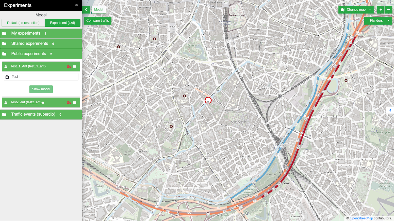
Fig. 1. A Road closure influence on traffic interactively modelled in the Traffic Modeller application (city of Antwerp).

The model will be then deployed as Traffic Modeller Application (see trafficmodeller.com for details) Therefore the OSM road network data has to be converted into a well-defined and topologically correct road network – fundamental constraining graph structure, which describes the allowed movements within a modelled area of interest. The Traffic generators coming from the Flanders model will then represent the supply and demand of car trips in the city. 


Having these two inputs, the third crucial input, the Origin-destination matrix (OD matrix) can be calculated. The OD matrix consists of cells representing the number of car trips from the origin (row) to the destination (column). This shows the distribution of the aforementioned supply and domain of traffic generators across the network. 

If the OD matrix has already been calibrated then there is no need for additional calibration measurements. But in any other case, a calibration process should take place. The calibration process uses calibration measurements of traffic volumes to confront and adjust the calculated traffic model to the observed reality. Traffic measurements (also called traffic census) are usually acquired at neuralgic points of the traffic network. The data for such a traffic census can be gathered by various sources (ANPR cameras, road built-in sensors, manual census, …). No matter the source, calibration measurements need further post-processing steps to clean observational or systematic errors, aggregate or harmonize observations to the same granularity and provide the statistical assessment. Last but not least, the GEH Statistics will be applied, comparing to Telraam or similar sensor data source. See more in Traffic modelling for the smart city of Pilsen manuscript, if interested.


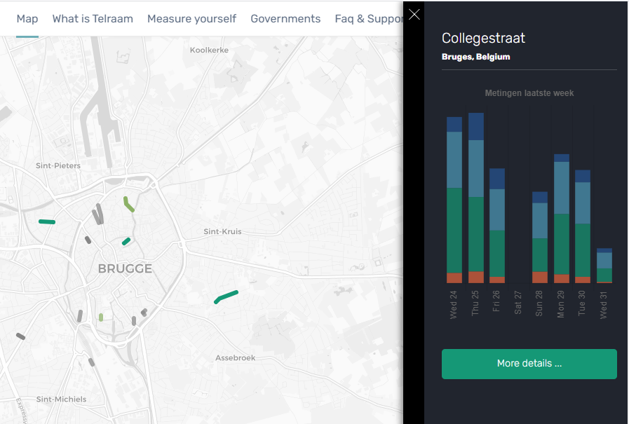
Fig.2 Telraam sensor in Brugge

The challenge runs under the umbrella of DUET and S4allCities H2020 projects. We are looking for volunteers willing to collaborate with us on the proposed topic. We plan to organize yourselves by a group chat, complemented by virtual calls (skype) during the challenge. 

***The registration for the challenges is open! If you are interested, do not hesitate to register for the hackathon HERE***

Your mentors are:

Karel Jedlicka – Karel’s research’s background lies in modeling, analysis, and even simulation using multidimensional (geographic) data structures. In particular, Karel actively researches on 3D and 4D aspects of Geographical Information Systems. Primarily Karel focuses on the following application domains: analysis of trends in climatic and weather data for agricultural purposes, influence of transport to the city life by designing and developing interactive traffic models for Digital twins of Smart cities. Karel has been leveraging his skills in various (mostly EU funded) projects since 2007. Karel usually acts as a leader of a research or technical team in the project. He has participated in Stargate, EUXDAT, AfarCloud, and DataBio projects related to agriculture and S4allCities, TRAFFO, DUET, PoliVisu, and OpenTransportNet projects related to Smart Cities.Karel works as a researcher at the University of West Bohemia, Deparment of Geomatics and the living lab Wirelessinfo. He is a deputy chairman of Plan4all Association and a co-founder of a traffic modelling Startup RoadTwin. 

DANIEL BERANDaniel graduated from the University of West Bohemia (UWB) at Faculty of Geomatics in 2018 with an Ing. degree (eq. to MSc). Since 2014 he has been active in various H2020 projects (OpenTransportNet, PoliVisu, DUET). In 2015 Daniel joined the Traffic Modeller team working as data manager and GIS analyst. Since 2018 he is undergoing a PhD study program at the UWB exploring classification of LiDAR point clouds. In 2018 and 2020 Daniel was a guest researcher at TU Delft and TU Wien respectively. He is a part time GIS teacher at Pilsen highschool of civil engineering. He has experience in GIS, traffic modelling, 3D visualization and point cloud processing. Daniel has been a mentor for several INSPIRE hackathon teams (e.g. Valmiera 2018, Nairobi 2019, Prague 2020).

JAN MARTOLOSJan is a traffic engineer specializing in mathematical modeling in transportation. He studied mathematics at the University of West Bohemia in Pilsen and traffic engineering at the Czech Technical University in Prague. He deals mainly with traffic surveys, traffic models, the capacity of intersections and research in transport.

Challenge #9: Agrihub Slovakia

Let’s make Slovak agriculture smarter, sustainable and competitive. The aim of the challenge is to build a Slovak Agricultural Innovation Hub. This activity will have several basic dimensions:

  • social – to build a community around the Slovak innovation hub
  • information – build an information Hub that will make available open data in Slovakia
  • data – collect and publish open data in a form that makes it easy to use
  • educational – to acquaint the community with the latest technologies and possibilities in the field of SmartFarming
  • start-up – to offer an environment for the development and emergence of new ideas
  • agricultural – to offer farmers transformational data into knowledge that will be applicable to them

The aim is to connect actors from development, the public sector, research with end users.

The purpose of the establishment of the Slovak AgriHub is the design and development of a smart technological innovation center for agriculture. The platform will be designed to create links between people, companies and other entities with knowledge and technology that will help in the implementation of innovative projects and ideas. One of the principles is to connect ordinary users with developers and researchers. The second principle is the integration of different types of demo applications, where farmers, developers and researchers will have the chance to collaborate, test different APIs for new solutions and also provide common experiments. The third principle is to make open data available in the Slovak Republic.

The solution is based on the use of Liferay Portal, including the integration of tools such as SensLog, HSlayers NG, QGIS, etc.

***The registration for the challenges is open! If you are interested, do not hesitate to register for the hackathon HERE***

RADOSLAV DELINA graduated at the Faculty of Economics, Technical University of Kosice, Slovakia. He has experiences from memberships in the European RTD Evaluation Network (Ares(2013)437085-MS) under DG Research and Innovation of European Commission, MGA WG DG R&I, expert advisor for the Ministry of Education Slovak Republic, for Ministry of Foreign Affairs of Japan in the field of research and innovation and international cooperation and from expertise for EC in different several initiatives. Radoslav has extensive RTD experiences from EU FPx research and development projects in the field of digital and data services innovation in different areas and as evaluator of FPx and national projects in different countries. Nowadays, he is focusing on socially responsible digital innovation with higher societal impact, transparency, smart data (data mining) services, e-procurement and decision making process automation. He is developing the concept of social farming 4.0, where smart technologies are helping with working inclusion and sustainability. He is a strong supporter of higher data driven transparency and social inclusion. His commercial activities are focusing on market intelligence for strategic and operational supply chain, fraud detection and public procurement transparency. Radoslav was the coordinator of H2020 CSA WIRE2017 project in the field of socially responsible digital RTD and reducing inequalities. He won first prize on eBF – Fair Sourcing Award in the IDEA section with data driven innovation for e-procurement.

HANA KUBICKOVA graduated in Geomatics, the University of West Bohemia in Pilsen. She is employed as project support at Plan4all and has an extensive experience in organizing the INSPIRE hackathons. She is involved in the development of digital innovation hubs for agriculture in the frame of various H2020 projects.


PETR UHLIR is a senior web designer oriented on user experience (UX) and frontend architecture with skills in Search Engine Optimisation (SEO), web marketing mix 4S (marketing mix focused on web environment extended about process management) and online marketing in general (SEO, SEM, Social media, emailing, etc.) which is in synergy with offline marketing. He is a creative person with feeling for aesthetics and design. Participated in more than 10 international projects. Education: Technical University in Prague, Faculty of electrical engineering – SW technologies and management; University of Economics in Prague, Faculty of Informatics and Statistics – Information Systems Management, Faculty of International Relations – Retail business