Challenge #9: Agrihub Slovakia

Let’s make Slovak agriculture smarter, sustainable and competitive. The aim of the challenge is to build a Slovak Agricultural Innovation Hub. This activity will have several basic dimensions:

  • social – to build a community around the Slovak innovation hub
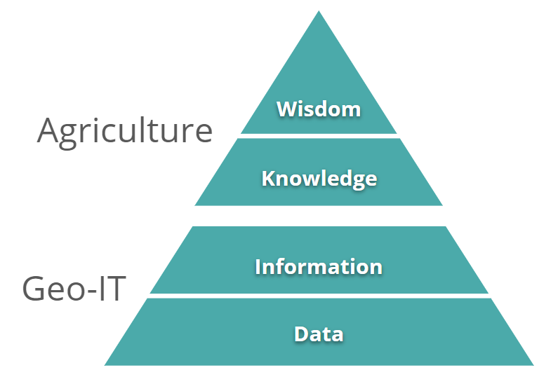
  • information – build an information Hub that will make available open data in Slovakia
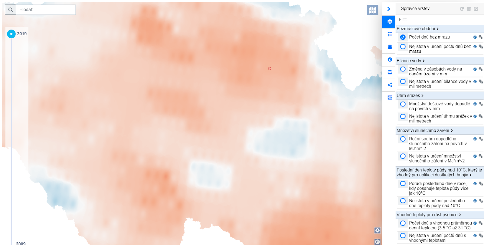
  • data – collect and publish open data in a form that makes it easy to use
  • educational – to acquaint the community with the latest technologies and possibilities in the field of SmartFarming
  • start-up – to offer an environment for the development and emergence of new ideas
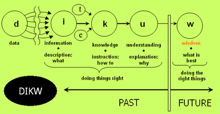
  • agricultural – to offer farmers transformational data into knowledge that will be applicable to them

The aim is to connect actors from development, the public sector, research with end users.

The purpose of the establishment of the Slovak AgriHub is the design and development of a smart technological innovation center for agriculture. The platform will be designed to create links between people, companies and other entities with knowledge and technology that will help in the implementation of innovative projects and ideas. One of the principles is to connect ordinary users with developers and researchers. The second principle is the integration of different types of demo applications, where farmers, developers and researchers will have the chance to collaborate, test different APIs for new solutions and also provide common experiments. The third principle is to make open data available in the Slovak Republic.

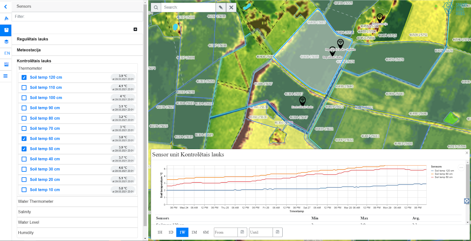
The solution is based on the use of Liferay Portal, including the integration of tools such as SensLog, HSlayers NG, QGIS, etc.

***The registration for the challenges is open! If you are interested, do not hesitate to register for the hackathon HERE***

RADOSLAV DELINA graduated at the Faculty of Economics, Technical University of Kosice, Slovakia. He has experiences from memberships in the European RTD Evaluation Network (Ares(2013)437085-MS) under DG Research and Innovation of European Commission, MGA WG DG R&I, expert advisor for the Ministry of Education Slovak Republic, for Ministry of Foreign Affairs of Japan in the field of research and innovation and international cooperation and from expertise for EC in different several initiatives. Radoslav has extensive RTD experiences from EU FPx research and development projects in the field of digital and data services innovation in different areas and as evaluator of FPx and national projects in different countries. Nowadays, he is focusing on socially responsible digital innovation with higher societal impact, transparency, smart data (data mining) services, e-procurement and decision making process automation. He is developing the concept of social farming 4.0, where smart technologies are helping with working inclusion and sustainability. He is a strong supporter of higher data driven transparency and social inclusion. His commercial activities are focusing on market intelligence for strategic and operational supply chain, fraud detection and public procurement transparency. Radoslav was the coordinator of H2020 CSA WIRE2017 project in the field of socially responsible digital RTD and reducing inequalities. He won first prize on eBF – Fair Sourcing Award in the IDEA section with data driven innovation for e-procurement.

HANA KUBICKOVA graduated in Geomatics, the University of West Bohemia in Pilsen. She is employed as project support at Plan4all and has an extensive experience in organizing the INSPIRE hackathons. She is involved in the development of digital innovation hubs for agriculture in the frame of various H2020 projects.


PETR UHLIR is a senior web designer oriented on user experience (UX) and frontend architecture with skills in Search Engine Optimisation (SEO), web marketing mix 4S (marketing mix focused on web environment extended about process management) and online marketing in general (SEO, SEM, Social media, emailing, etc.) which is in synergy with offline marketing. He is a creative person with feeling for aesthetics and design. Participated in more than 10 international projects. Education: Technical University in Prague, Faculty of electrical engineering – SW technologies and management; University of Economics in Prague, Faculty of Informatics and Statistics – Information Systems Management, Faculty of International Relations – Retail business

Open Spring INSPIRE Hackathon 2021 Kick-off Webinar

The Open Spring INSPIRE Hackathon is about to start! Therefore, we are planning a kick-off webinar on 6th April at 2:30 PM CEST, where all 11 challenges will be introduced by their mentors in the form of 5-minute pitch!  In addition to the objectives of the challenges and the introduction of mentors, in this webinar you will learn how to join the challenge you might be interested in and how such an INSPIRE Hackathon works.

The Open Spring INSPIRE hackathon 2021 (March – May) will be focused on developments and innovations in agriculture, the environment, transport, tourism, geospatial applications or remote sensing and GNSS.

In case of your interest, do not hesitate to register for this webinar HERE!

***The registration for the challenges is open! Check the table below, choose the challenge and register for the hackathon HERE***

Link to the webinar is as follows:

https://zoom.us/j/91789159796?pwd=cGJDZXZTdllYQ0d4TFEzTGErMCt5QT09

CHALLENGEPROJECT TITLE & DESCRIPTIONMENTOR
1How to use and improve OLU 2.0.0
The aim of the Challenge is to verify and test the possibility of using the geographical database OLU 2.0.0 for various areas of human activity - spatial planning, modeling, visualization, but also in commercial applications - real estate, investment evaluation, etc. The aim is to support the use of OLU in various areas gather data for further development of the OLU database.
Karel Charvát, Kristýna Čerbová
2Regional Atractiveness
This challenge’s primary goals are to explore and develop different forms of simple, understandable, and tempting attractive communication of regional attractiveness assessment. The challenge results will help identify and visualise similarities and differences between various regions based on statistical data. The team should consider, test and experiment with multiple approaches that include but are not limited to index calculation, clustering or machine learning methods.
Karel Charvát, Otakar Čerba
3Analysis of Drought Conditions for Selected Use-Cases
Drought is a natural hazard that has significant impacts on the environment, society, and economy. In this challenge we will apply various drought indices to investigate the occurrence of drought conditions for several STARGATE use-cases in Europe. The aim of the challenge is to assess drought risk by applying drought indices to weather simulation models and earth observation data for selected use-cases.
Amit Kirschenbaum
4Analytical map of traffic accidents in Czechia
Set up an analytical map of traffic accidents in Czechia, taking advantage of the GLayer engine provided by InnoConnect.
Frantisek Kolovsky, Jiri Bouchal
5SmartAfriHub III - African Agricultural Water Security
The goal is to continue building the African Community to support SmartFarming in Africa.
Tuula Löytty, Markéta Kollerová, Karel Charvát
6Analysis of Sentinel 2 and Sentinel 1 time series for the purpose of Agriculture
This challenge aims at following:
Comparison of different indices including developing web based environment for data comparison
Time series crop classification testing different possibilities like transfering classification form one season to other or from one region to the other
Analysis of dynamism of different indices in the field and comparison with other data like meteorological and climatic data
Comparison of different phenology status inside of farm
Comparison of phenology status of single crops between seasons
Updating Land Use maps
Herman Snevajs, Iva Batrlova
7Interactive collaborative data capturing at scale - technology and business models
A MapWhiteboard is a technology that allows several users to work collaboratively “in” the same map, the way people do with documents in Google Docs or Office 365.
The challenge for the hackathon is two-fold: The technical challenge for developers is to ensure the scalability of the current proof-of-concept to handle large-scale real-world user loads. To date, no benchmark has been established to determine the capacity and hardware requirements for the challenge.
The business challenge for those who wish to transform tech into added value for society: How to capitalize on whiteboard technology
For government, academia, business, individuals
How can it be made into a cross-platform enabler (serve different tech silos, providers)
What are the “killer” use-cases and applications for this technology
How can this be offered as a service, licensing and IPR concerns - open or proprietary, on-premise, decentralized or SaaS
Runar Bergheim, Karel Charvát, Eliška Janošíková
8AgroInfo Application
Design of AgroInfo - (web-based) application gathering information from various sources into an integrated, easy to interpret environment. The outcome of the challenge should be a detailed analysis of needs, the definition of use-cases, and app wireframes that could be used as a basis for developing the web application.
Karel Jedlička, Frantisek Zadrazil, Pavel Hajek, Heřman Šnevajs, Jirka Valeš, Tomáš Andrš
9Agrihub Slovakia
Let's make Slovak agriculture smarter, sustainable and competitive. The aim of the challenge is to build a Slovak Agricultural Innovation Hub.
Petr Uhlíř, Hana Kubíčková, Radoslav Delina
10Evaluation of OSM 4 purposes of Traffic Modelling
The goal of our challenge is to evaluate the suitability of the OpenStreetMap street network for a traffic model creation, focusing on the quality of attributes (prohibited turns and road capacity mainly) using GEH Statistics, compared to available traffic measurements.
Karel Jedlička, Daniel Beran, Jan Martolos
11From Smart Points of Interest towards sustainable Points of Interest
The goal of the challenge is to create a robust, easily maintainable pipeline for OSM and other data resources to SPOI transformation and to find a sustainable business model for SPOI spoject. We will look at new methods of building SPOI, but the main focus will be on areas where SPOI can be used and how to integrate SPOI with other data and provide custom analysis for different stakeholders groups. We will look on synergis with such data sets like Open Land Use and other data sources.
Jan Macura, (Stein) Runar Bergheim

Challenge #8: AgroInfo Application

A goal of this challenge is to design a prototype of an application, helping a farmer to make proper decisions leading to high yields whilst farming in a sustainable way. We believe that an evidence based decision making is the right way to do so. 

The evidence comes from data, turned into information. The information then needs to be presented in a clear way, to help understanding of a studied system (knowledge) and objective reasoning (wisdom). 

Fig 1. A flow diagram of the DIKW, source: https://en.wikipedia.org/wiki/DIKW_pyramid

Whereas the knowledge and reasoning/wisdom is here in the domain of agriculture, the data and information lies in the domain of geo-IT expert.


Fig 2. DIKW pyramid, created by authors

There is always a gap in between the Geo-IT and agriculture domain, which can cause misinterpretation of the provided information. We believe that a well designed application can help to minimize this risk. Therefore we would like to apply User eXperience (UX) based approach for the application design and prototype development. We understand that such an application can be quite complex, therefore we will start to work on two components of the application: agroclimatic factors calculated from climatic data and yield monitor based on the remote sensing data. We will take existing standalone applications (AgroClimatic Atlas prototype and  yield monitor) as an input and put effort into integrating and simplifying them for the sake of the end-user.

Fig 3. Prototype of AgroClimatic Atlas, source https://www.agrihub.cz/hsl-ng/AgroClima 

Fig 4. Prototype of yield monitor

The UX driven design of the integral application will be created by analysis of user needs, captured in a form of clearly described Use Cases. Each Use Case, describing an interaction of a user and the application, will be complemented with a mockup portraying the GUI involved in the Use Case, see example of a Mockup below.

Fig 5. Mockup of Water Balance factor visualization, source: T. Andrš. Visualization of spatiotemporal phenomena – an example of agroclimatic factors, University of West Bohemia, bachelor thesis, ongoing. 


The challenge will be driven by a group chat, complemented by virtual calls (skype), together with a task manager (redmine).

The challenge runs under the umbrella of Stargate, Sieusoil, Smartagrihubs and Demeter H2020 projects and InteCom project.

***The registration for this challenge opens on 1st April***
Registration link will be available at https://www.plan4all.eu/open-spring-inspire-hackathon-2021/

Your mentors are:

Karel Jedlicka – Karel’s research’s background lies in modeling, analysis, and even simulation using multidimensional (geographic) data structures. In particular, Karel actively researches on 3D and 4D aspects of Geographical Information Systems. Primarily Karel focuses on the following application domains: analysis of trends in climatic and weather data for agricultural purposes, influence of transport to the city life by designing and developing interactive traffic models for Digital twins of Smart cities. Karel has been leveraging his skills in various (mostly EU funded) projects since 2007. Karel usually acts as a leader of a research or technical team in the project. He has participated in Stargate, EUXDAT, AfarCloud, and DataBio projects related to agriculture and S4allCities, TRAFFO, DUET, PoliVisu, and OpenTransportNet projects related to Smart Cities.Karel works as a researcher at the University of West Bohemia, Deparment of Geomatics and the living lab Wirelessinfo. He is a deputy chairman of Plan4all Association and a co-founder of a traffic modelling Startup RoadTwin. 

František Zadražil is a Project Coordinator of the HSLayers-NG framework. He has been working in the GIS field since he graduated in 2006 (Computer Graphics and Virtual Reality Engineering). After the years of SW development using various platforms (MapServer, GeoServer, ArcGIS) he became a GIS team leader and project manager and contributed to implementing numerous GEO systems for the public and private sector. He has expertise in GIS architecture and analysis. 

Pavel Hajek is a researcher and a lecturer at the Department of Geomatics. He participated in several EU projects such as OpenTransportNet, GEPAM, Peregrinus Silva Bohemica, or EUXDAT. His focus is mainly on data modeling, assembling, and gathering. His doctoral internship was taken at TU Delft (2014). Research activities: Geographic Information Systems (GIS), multidimensional data modeling – especially 3D data handling, cartography and visualization, 3D GIS/CAD/BIM.


Challenge #7: Interactive collaborative data capturing at scale – technology and business models

A MapWhiteboard is a technology that allows several users to work collaboratively “in” the same map, the way people do with documents in Google Docs or Office 365. Other users can see “my” cursor, and I can see “theirs”. We can all draw and edit on the same map and collaboratively add geometries and attributes. This technology is seen as having use cases within distributed or decentralized data capture.


Prototype application of MapWhiteBoard

The challenge for the hackathon is two-fold:

  1. The technical challenge for developers is to ensure the scalability of the current proof-of-concept to handle large-scale real-world user loads. To date, no benchmark has been established to determine the capacity and hardware requirements for the challenge. The challenge includes both to set such a benchmark and to push the performance of the technology to a level that is realistic for production scenarios with large-scale concurrent usage in terms of number of users per second, concurrent use, data volume transferred etc. Solutions might include enhancements to software or scaling of hardware 
  2. The business challenge for those who wish to transform tech into added value for society: How to capitalize on whiteboard technology
    • For government, academia, business, individuals
    • How can it be made into a cross-platform enabler (serve different tech silos, providers)
    • What are the “killer” use-cases and applications for this technology
    • How can this be offered as a service, licensing and IPR concerns – open or proprietary, on-premise, decentralized or SaaS

More information about this challenge can be found HERE!

***The registration for this challenge opens on 1st April***
Registration link will be available at https://www.plan4all.eu/open-spring-inspire-hackathon-2021/

Your mentors are:

Eliska Janosikova graduated at Brno University of Technology, Faculty of Electrical Engineering and Communication, in Electrical manufacturing and management. She works as business analyst and project support.


(Stein) Runar BergheimRunar  manages research and development at Asplan Viak Digital services. Asplan Viak is one of the leading consultancy houses in Norway.  During the span of his career, Mr Bergheim has undertaken more than two hundred projects in more than twenty countries. His key areas of expertise are design, supervision and management of information technology projects with four professional focal points: planning, land management, cultural heritage and e-learning.

Karel Charvat graduated in theoretical cybernetics. He is a member of International Society for Precision Agriculture, Research Data Alliance, vice chair of Club of Ossiach, CAGI, and CSITA. He was in period 2005 – 2007 President of European Federation for Information Technology in Agriculture Food and Environment (EFITA). Now is chair of OGC Agriculture DWG. He was organiser on many hackathons, where as most important were series of INSPIRE Hacks and MEDHackathon. He work on implementation on national INSPIRE Geoportal. Now he is also active in Plan4all association. He has long time experience in ICT for Environment, transport, Agriculture and Precision Farming. Now he is one from promoters of Open and Big Data in Agriculture in Europe. Participation in projects: Wirelessinfo, Premathmod, EMIRES, REGEO, RuralWins, Armonia, aBard, EPRI Start, Ami@netfood, AMI4For, Voice, Naturnet Redime, Mobildat, SpravaDat, Navlog, c@r, Humboldt, WINSOC, Plan4all, Habitats, Plan4business, SmartOpenData, FOODIE, SDI4Apps, AgriXchange, FOODIE, SDI4Apps, OTN, DataBio, EO4AGRO, EUXDAT, SmartAgriHub, SKIN and other projects.

Challenge #6: Analysis of Sentinel 2 and Sentinel 1 time series for the purpose of Agriculture

Current agriculture faces two serious requirements: 1, To maximize the productivity in order to provide enough food for the growing population and use the land as effectively as possible. 2, To be sustainable, environment friendly and as green as possible. Both the demands have logical arguments. The only answer which fulfills both of the needs is precision farming.

We make the best of Earth Observation to provide the farmers with the desired information. In the challenge satellite data from the open European space programme Copernicus will be used. The advantage of satellite Sentinel-1 is the radar signal which is not influenced by clouds and does not need daylight. On the other hand Sentinel-2 carries an optical multispectral instrument which collects the data in many wavelengths useful for crop monitoring. The optical indices are also much better documented. Both of the state-of-the-art satellites have very good spatial and time resolution. 

We will build on previous INSPIRE hackathons. The present state of the analysis is to be found on the Czech FOODIE AgriHub portal. The task of the challenge is to improve and extend the analysis. . 

We will experiment with classification algorithms and quantify the accuracy of the results. The classification should be done on more farms and during more years. We can also try classification using neural networks. All the trials should be listed in well-arranged comparison.

We will calculate the average index for particular crops in different years and compare the seasons to each other. This should be done for more indices.

We want to try the existing analyses in different conditions – on different farms. 

We are considering deploying more data sources, especially thermal data. We are open to new ideas.

***The registration for this challenge opens on 1st April***
Registration link will be available at https://www.plan4all.eu/open-spring-inspire-hackathon-2021/

Your mentors are:

Iva Batrlova graduated from ecology and landscape planning at Czech University of Life Sciences in Prague. Now she is a Remote Sensing Specialist at CENIA, czech environmental information agency. She is involved in research activities and is currently dealing mainly with radar satellite data, but is also involved in other projects with use of thermal and optical data. She is dealing mostly with proccesing of long time data series and focuses on the impact of energy flows in the landscape on the environment.

Herman Snevajs graduated with a bachelor degree from Palacky University in Geoinformatics, Cartography and Remote Sensing in 2019. He specializes in Earth Observation – water retention, drought monitoring and use of machine learning

Challenge #5: SmartAfriHub III – African Agricultural Water Security

The goal is to continue building the African Community to support SmartFarming in Africa.

The challenge combines three concepts:  

  • Educathon – we support further development of African SmartFarming capacity development by providing rich content at SmartAfriHub
  • Datathon – we support building an Open Repository of Data in Africa and
  • Ideathlon – we collect ideas and needs to enhance Food, and particularly Agricultural Water Security by enhancing the local Food Nutrition Surveillance System (FNSS).

We embrace transversally, over all three concepts, the COVID-19 era experiences,  observations, best practices and innovations. The ultimate goal is to build local food and specially Agricultural Water Security that is resilient in any circumstances.    

In addition,  the goal is also to support publishing of new scientific papers and building of potential consortia for research projects.   

During the previous two years Plan4All has organized 3 INSPIRE Hackathons (Nairobi, Kampala and COVID-19) that have reached out to hundreds of African smart agriculture experts, practitioners and stakeholders.  As a result of these hackathons we have a African community of practice which is active in Digital Innovation Hub –  SmartAfriHub, Whatsapp and Facebook.   Our goal is to continue and extend these activities by leveraging  OpenSpring INSPIRE Hackathon.

Educathon

Digital Innovation Hub – SmartAfriHub  (https://www.smartafrihub.com/cs/about-project) platform connects people to the information and facilitates capacity development. Firstly, leveraging social media type of features like Blog, Forum, Science Shop and connecting users with developers and researchers. And secondly,  by sharing demo applications, where farmers, developers and researchers have a chance to cooperate, test different API for new solutions and also provide common experiments. 

Digital Innovation Hub is based on the use of Liferay Portal and as a backend, it uses SQL and non-SQL database and integrates tools like SensLog, HSlayers NG etc.

Our development goals are to improve SmartAfriHub based on user’s feedback and suggestions, to integrate new functions on the platform,  and to engage new organizations and individuals to share their own content through the platform. 

Datathon

In the area of  open data we see following pathways:

  • using QGIS Layman to collect data from different countries and regions in Africa
  • promote utilisation of COPERNICUS data with focus also on Sentinel 1
  • collecting a database of best practices by using Best Practices Atlas.

Ideathon

According to FAO, Food Security is “a situation that exists when all people, at all times, have physical, social and economic access to sufficient, safe and nutritious food that meets their dietary needs and food preferences for an active and healthy life” .  The four pillars for Food Security are (Figure 1): 

  • Availability 
  • Access 
  • Use and Utilization 
  • Food System stability 

Figure 1: Food Security  (ref. https://wocatpedia.net/wiki/Definition_and_Dimensions_of_Food_Security)

The starting point is the first pillar of Food Security, which is “Availability” which refers to the physical existence of food and water. 

  • Globally: Irrigated agriculture represents 20 % of the total cultivated land and contributes 40% of the total food produced worldwide. Currently, agriculture accounts for 70 % of all freshwater withdrawals globally. However, there is pressure for water re-allocation which means that 25-40% of agricultural water will be reduced. 
  • Africa: Agriculture is the largest user of water in Africa, accounting for about 85-88 % of total water use. Yet only 185 million ha or 6 % of the total area of the region is under cultivation. Of this, some 12 million or 6% of the total cultivated area is under irrigation. (Source)

The World Health Organisation (WHO) published in 1984 a description of a Food Nutrition Surveillance System (FNSS).The national and local nutrition surveillance systems focus on identifying trends in key nutrition-related health indicators for their populations, with particular attention on vulnerable groups. The objectives are: 

  • Monitor population health and nutritional status
  • Deliver trustworthy data on the people nutritional status
  • Show trends and comparisons
  • Raise awareness about nutritional problems
  • Provide guidance to health-related intervention programs 

The national and local authorities’ responsibility is to establish a pragmatic and reliable surveillance system to alarm and prevent water availability and water quality-related food security problems and risk.

This hackathon challenge is addressed to African communities’ Agricultural Water Security. The aim is to grasp local current situations, identify needs and ideate solutions to improve the water monitoring system.  

The water monitoring system encompasses e.g. collecting data, analyzing data and sharing data with feasible and robust digital tools to enhance decision making, risk management and development.

***The registration for this challenge opens on 1st April***
Registration link will be available at https://www.plan4all.eu/open-spring-inspire-hackathon-2021/

The mentor of this challege are:

TUULA LÖYTTY earned her MSc in Industrial Engineering and Management from Lappeenranta-Lahti University of Technology. She has worked for 18 years at the private sector corporations such as dairy-, sugar- and metal industry and for 18 years at the higher education in three different universities contributing research and innovation action. Digital solutions and ICT technology have been part of her work since 80′ and she prefers to act as a bridge between IT – developers and end-users.  She launched the new phase in 2018 when she jumped into an entrepreneur career.  She is a member of Plan4all (www.plan4all.eu) committee. Co-operation with Plan4all has encompassed mentoring in Nairobi, Kampala and COVID-19 Inspire Hackathons in 2019-2020.

MARKETA KOLLEROVA studied Linguistics at University of South Bohemia. In the Plan4all team, she is responsible for international cooperation and communication, where she uses her experience from her past life as a foreign mission clerk. Enjoys the comparison of living in different countries and regions.


KAREL CHARVAT graduated in theoretical cybernetics. He is a member of International Society for Precision Agriculture, Research Data Alliance, vice chair of Club of Ossiach, CAGI, and CSITA. He was in period 2005 – 2007 President of European Federation for Information Technology in Agriculture Food and Environment (EFITA). Now is chair of OGC Agriculture DWG. He was organiser on many hackathons, where as most important were series of INSPIRE Hacks and MEDHackathon. He work on implementation on national INSPIRE Geoportal. Now he is also active in Plan4all association. He has long time experience in ICT for Environment, transport, Agriculture and Precision Farming. Now he is one from promoters of Open and Big Data in Agriculture in Europe. Participation in projects: Wirelessinfo, Premathmod, EMIRES, REGEO, RuralWins, Armonia, aBard, EPRI Start, Ami@netfood, AMI4For, Voice, Naturnet Redime, Mobildat, SpravaDat, Navlog, c@r, Humboldt, WINSOC, Plan4all, Habitats, Plan4business, SmartOpenData, FOODIE, SDI4Apps, AgriXchange, FOODIE, SDI4Apps, OTN, DataBio, EO4AGRO, EUXDAT, SmartAgriHub, SKIN and other projects.

Challenge #4: Analytical map of Traffic Accidents in Czechia

The goal of the challenge is to develop an analytical map of traffic accidents in Czechia using GLayer, a tool for interactive visualisation of big & complex multidimensional spatial data through linked views. GLayer, is an innovative GPU computing tool designed for compute-intensive jobs. It’s parallel architecture delivers high computing performance. GLayer includes a geo-enabled database with a rendering option that is able to store, query and render billions of records. GLayer supports SQL-like queries and provides graphical output of aggregated data such as heatmaps (point or line-based). 

InnoConnect will provide the applicant with admin access to the GLayer configuration dashboard through which the analytical map project will be configured (only basic coding skills required).

The official traffic accident data provided by the Police (source) might be either processed by the applicant independently and connected to the GLayer backend via PostGIS or ClikHouse connectors (support will be provided) or a pre-processed data can be provided by InnoConnect.

Example: GLayer analytical map


Example: GLayer project configuration

***The registration for this challenge opens on 1st April***
Registration link will be available at https://www.plan4all.eu/open-spring-inspire-hackathon-2021/

Jiri Bouchal is a co-founder and director at InnoConnect.net, a technology start-up company that delivers location intelligence services to clients in the fields of smart cities, smart mobility, Internet of Things, open data and geo-data analytics & visualisation.
Jiri’s main fields of expertise include business development, business analysis, innovation management, (geo)data analytics and visualizations, functional analysis and UI design, smart city policies, eGovernment services, and smart mobility. Jiri has a successful track record in H2020 research & innovation funding, being engaged as a project manager of multiple innovation projects.
Jiri obtained MA diplomas in Law and in European Studies.
More info about Jiri can be found at: https://www.linkedin.com/in/jiribouchal/

Frantisek Kolovsky holds a position of the senior backend developer at InnoConnet and is a PhD student at University of West Bohemia (UWB). His main area of expertise include transportation algorithms, routing algorithms and processing of big spatial data.
Frantisek research focused on routing algorithms was awarded  by a 3rd place during the ACM SIGSPATIAL Cup 2015 competition (Seattle, US).
Frantisek has also been working as a software developer in several European research & innovation projects: DUET, PoliVisu, OpenTransportNet and Plan4business. He holds an Ing. (M.Eng) diploma in Geomatics from UWB.


Challenge #3: Analysis of Drought Conditions for Selected Use-Cases

Drought is a natural hazard that can be loosely defined as an abnormally long, though temporary, time period of water deficit. Europe has experienced a series of drought events for over a decade, which lead to devastating impacts on livelihoods, ecosystems, and agriculture. Though droughts cannot be avoided, we can try to manage them better and reduce their effects. This requires, first, monitoring drought conditions in a timely manner and evaluating their severity. Drought is commonly divided into subcategories based on disciplinary perspectives, each incorporates different physical, biological, and socio-economic factors in its definition. In the STARGATE project we focus on designing a multiscale methodology of Climate Smart Agriculture, therefore our interests are mainly in meteorological and agricultural drought categories. The information gained from drought analysis will be valuable for different stakeholders, such as farmers and decision makers. Meteorological drought is a prolonged period of precipitation deficiency, which may be accompanied by higher temperatures and lower humidity relative to the norm for a particular area. Agricultural drought comes after meteorological drought has established; this is associated with soil moisture deficiency during crop development. Drought severity, duration, and frequency will be inferred through indices, which incorporate features that reflect it. In case of meteorological drought, this means, e.g., precipitation and temperature. Agricultural drought features also involve, e.g., measurements of soil moisture, or indicators that reflect plant water stress.  The goal is to extract these features from weather models and earth observation to assess drought risk for selected use-cases of different scales – from regional to farm level.

Requirements for team members: software development, statistical modelling, geo-sciences specialists, agronomist

The aim of the challenge: The aim of the challenge is to assess drought risk by applying drought indices to weather simulation models and earth observation data for selected use-cases. 

***The registration for this challenge opens on 1st April***
Registration link will be available at https://www.plan4all.eu/open-spring-inspire-hackathon-2021/

The mentor for this challenge is:

Amit Kirschenbaum is a research associate at the Institute for Applied Informatics (InfAI), Leipzig. He currently works on the H2020 STARGATE project, where he focuses on climatic data analysis and data integration for smart agriculture.

Why to vote for Groundwater FIE in WSIS Prizes 2021

Attention to the application in last days has brought us to the idea of an interview with developers of the application. Developers described the application in short 8 questions that could provide you the overall idea what is the application all about, what benefits it provides and how you can start to use it. The record of the interview is on YouTube.

The application is available at:  https://groundwater.smartagro.lv/

Please, support our colleagues by YOUR VOTE by the end of March! 

How to vote for FIE20: Groundwater and meteo sensors?

  1. Registration – please register under the following link, you will receive a verification email with a link https://www.itu.int/net4/wsis/stocktaking/Account/Register?ReturnUrl=%2Fnet4%2Fwsis%2Fstocktaking%2FPrizes%2F2021%2FVote
  2. Log in
  3. In the menu, click on Prizes and then on the Vote button (or directly on the link below)
    https://www.itu.int/net4/wsis/stocktaking/Prizes/2021/Vote
  4. Select a category: AL C7.E-environment and you can vote

Challenge #2: Regional Attractiveness

This challenge’s primary goals are to explore and develop different forms of simple, understandable, and tempting attractive communication of regional attractiveness assessment. The challenge results will help identify and visualise similarities and differences between various regions based on statistical data. The team should consider, test and experiment with multiple approaches that include but are not limited to index calculation, clustering or machine learning methods.

The work in the challenge will be divided into three tasks: data, application and testing.

The data group will focus on optimising existing input data sets, adding new data, and dealing with data semantics, including classification of input data according to various classification systems (e.g. UN SDG, GEMET, RRI pillars etc.). Also, calculation methods and assessment of the attractiveness will be moved on, including testing machine learning approaches.

The application group will develop and improve existing interactive web application(s) showing attractiveness maps (index and clusters). The goal of the application’s development is to provide more opportunities for adjusting the perspective of attractiveness assessment to concrete user requirements.

The challenge will be tested in different scales including parcel level


The application is available at https://hub.polirural.eu/hsl-ng/rural-attractiveness-cz/

The testing group will guarantee communication with stakeholders, including providing feedback for developers and data experts and initial development of business models.. 

The results will be presented on cases focused on the Polirural project (NUTS 3 regions in Europe), Czech municipalities, African countries and other areas.

***The registration for this challenge opens on 1st April***
Registration link will be available at https://www.plan4all.eu/open-spring-inspire-hackathon-2021/

The mentors for this challenge are:

OTAKAR CERBA Assoc. prof. Otakar Čerba, PhD works at the Department of Geomatics (Faculty of Applied Sciences, University of West Bohemia, Plzeň, Czech Republic) and cooperates with Plan4all. He is focused on cartographic visualization of spatial data, Linked Data on the geographic domain and semantic issues of geographic data. He has been involved in many international projects such as Polivisu, Humboldt, SDI4Apps, SmartOpenData, Plan4all or ROSIE. Otakar Čerba is the member of the board of Czech Association of GeoInformation and the chair of the Commission on Maps and the Internet of International Cartographic Association

KAREL CHARVAT graduated in theoretical cybernetics. He is a member of International Society for Precision Agriculture, Research Data Alliance, vice chair of Club of Ossiach, CAGI, and CSITA. He was in period 2005 – 2007 President of European Federation for Information Technology in Agriculture Food and Environment (EFITA). Now is chair of OGC Agriculture DWG. He was organiser on many hackathons, where as most important were series of INSPIRE Hacks and MEDHackathon. He work on implementation on national INSPIRE Geoportal. Now he is also active in Plan4all association. He has long time experience in ICT for Environment, transport, Agriculture and Precision Farming. Now he is one from promoters of Open and Big Data in Agriculture in Europe. Participation in projects: Wirelessinfo, Premathmod, EMIRES, REGEO, RuralWins, Armonia, aBard, EPRI Start, Ami@netfood, AMI4For, Voice, Naturnet Redime, Mobildat, SpravaDat, Navlog, c@r, Humboldt, WINSOC, Plan4all, Habitats, Plan4business, SmartOpenData, FOODIE, SDI4Apps, AgriXchange, FOODIE, SDI4Apps, OTN, DataBio, EO4AGRO, EUXDAT, SmartAgriHub, SKIN and other projects.