We are looking for innovative challenge ideas focused on Nature-Based Solutions (NBS) for sustainable agriculture and land management!
By fostering collaboration between the EU and China, the hackathon aims to inspire young farmers, students, and professionals to engage in creating innovative business ideas utilising NBS technologies.
This aligns with the broader ambition of trans4num to enhance NBS implementation through a multi-level approach involving academic partners, practice partners, and societal stakeholders.
This is a unique opportunity to contribute to the development of impactful solutions, work with like-minded individuals from around the world, and benefit from the knowledge and experience of seasoned mentors.
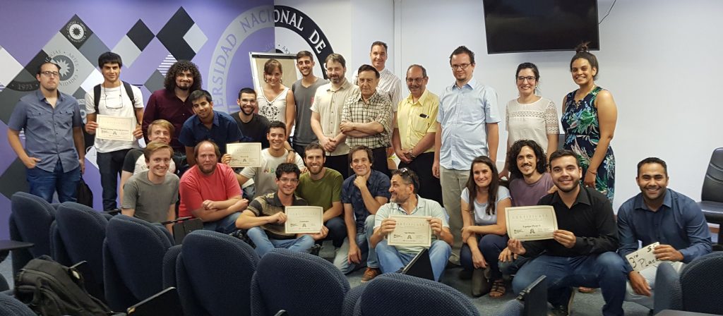
The #SanJuanINSPIREHackathon is over. All the teams did excellent work! The jury was impressed and it was really hard to evaluate the projects and select the winner.
Finally, the results are:
1st place – Agrohacks
2nd place – Cammalot
3rd place (with the equal score) – Equipo INAUT & P.G.I.C.H
4th place – Remote Sensing UNSJ Argentina
Final presentations of the team’s projects follow.
Agrohacks
Down To Earth ~ a tool alerting farmers about forecasted severe weather conditions
Mathematical modeling software, such e.g. Software R, MathLab, …
Earth Observation data processing software, such as Goolge Earth Engine, OrfeoToolbox, …
Spreadsheets, such as google docs, Libre Office, Microsoft Office, …
Where should I document my progress?
There is a google document dedicated to the detailed description of your team. You should shortly introduce your team, describe the initial idea and keep track of your progress. You can use either the one document prepared for all teams together or you can create your own document and link it in the parent doc.
How can I provide my feedback?
There is a form prepared for your feedback. You can either provide feedback on behalf of the team together or you can give us your personal feedback. Please fill at least one feedback per team until the end of Friday. But you can fill the feedback continuously during the hackathon, as once you fill it for the first time, you are provided with a link to edit your feedback anytime.
Making climate-related decisions using relevant data
The aim of this hackathon is to leverage a combination of sensors, climatic services, and Earth Observation data in agriculture.
The San Juan INSPIRE Hackathon 2019 is one of the satellite INSPIRE hackathons. The hackathon is second DataBio and the first EUXDAT hackathon held outside the EU, also other EU projects are involved, namely: AgriClima, NextGEOSS, EO4AgriAFarCloud and Stargate.
The #SanJuanINSPIREHackathon is over. All the teams did excellent work! The jury was impressed and it was really hard to evaluate the projects and select the winner.
Finally, the results are:
1st place – Agrohacks
2nd place – Cammalot
3rd place (with the equal score) – Equipo INAUT & P.G.I.C.H
4th place – Remote Sensing UNSJ Argentina
Final presentations of the team’s projects follow.
Agrohacks
Down To Earth ~ a tool alerting farmers about forecasted severe weather conditions
Digital Elevation Model downloaded from SRTM, resp. the source OF DEM is ALOS Global Digital Surface Model called AW3D30 – For more information see https://www.eorc.jaxa.jp/ALOS/en/aw3d30/index.htm (registration needed for downloading data).
Sensor data of soil water potential, soil temperature, air temperature air humidity, from period 2016/01/26 – 2017/03/13. See a gpx file for the localization of the sensors and details about the measured quantities.
Moreover, the teams will get access to EUXDAT online platform allowing python coding together with access to the provided data (detailed information will follow.
Additionally to the data and the platform, the teams will be provided by inspiration of what can be achieved by the use of climatic data combined with sensor and elevation data by showing:
the example of Agroclimatic Atlas Of Canada, e.g. map of Fall Freeze Dates: Average Dates of First Fall Freeze for an example of the desired result.
There will be a room with internet access available. However, teams are supposed to bring their own hardware.
Challenge
The teams will be then challenged to follow the basic experiment described or/and to invent their own way of potential usage of the provided data and tools.
All of the following types of outcomes are acceptable as hackathon results:
concept of what can be achieved with the data
basic algorithm description
working prototype
All presented hackathon results will be then evaluated by the expert jury and the first three teams will be awarded:
1st prize – USD 200
2nd prize – USD 100
3rd prize – USD 50
Jury
Dr. Ing. Oscar Raúl Dölling (chairman) Integrated Watershed Management, Hydraulic and Environmental Engineering Program of the UNSJ. Dr. Lic. Arnobio Germán Poblete Climatology program of the Institute of Geography of the UNSJ.
In order to participate in the hackathon, please register your team here. Please note that the expected team size is 2-6 persons. Each team should have a name (to distinguish among teams) and a contact person who will communicate with the organizers.
The hackathon run from Tuesday 19.11.2019 to Friday 22.11.2019. Please note that the following details still can be a subject of change:
Tuesday morning:
8:30 – 8:55 ~ registration of teams
9:00 – 9:30 ~ hackathon opening
9:30 – 10:00 ~ detailed information of the hackathon organization, including initial information about the hackathon topic, including a description of data to be used + platform, which can be used
10:00 – 11:00 ~ team’s introduction (3-5 min for each team, no presentation needed – please focus on the description of your initial idea).
Tuesday afternoon – Friday morning
hacking, ad hoc consultations.
Friday afternoon
14:00 – 15:30 ~ Presentation of results (each team has 10 minutes for presentation + 5 minutes for Q&A
15:30 – 16:00 ~ Evaluation of the teams by jury
16:00 – 16:30 ~ Awarding and closing ceremony
ORGANISERS AND SUPPORTERS
DataBio (http://databio.eu/) – The data intensive target sector selected for the DataBio project is the Data-Driven Bioeconomy, focusing in production of best possible raw materials from agriculture, forestry and fishery/aquaculture for the bioeconomy industry to produce food, energy and biomaterials taking into account also various responsibility and sustainability issues. DataBio proposes to deploy a state of the art, big data platform “on top of the existing partners” infrastructure and solutions – the Big DATABIO Platform. The work will be continuous cooperation of experts from end user and technology provider companies, from bioeconomy and technology research institutes, and of other partners. In the pilots also associated partners and other stakeholders will be actively involved. The selected pilots and concepts will be transformed to pilot implementations utilizing co-innovative methods and tools where the bioeconomy sector end user experts and other stakeholders will give input to the user and sector domain understanding for the requirements specifications for ICT, Big Data and Earth Observation experts and for other solution providers in the consortium.
EUXDAT – (http://www.euxdat.eu) proposes an e-Infrastructure, which addresses agriculture, land monitoring and energy efficiency for a sustainable development, as a way to support planning policies. In order to do so, we need to address the problems related to the current and future huge amount of heterogeneous data to be managed and processed. EUXDAT builds on existing mature components for solving them, by providing an advanced frontend, where users will develop applications on top of an infrastructure based on HPC and Cloud. The frontend provides monitoring information, visualization, different parallelized data analytic tools and enhanced data and processes catalogues, enabling Large Data Analytics-as-a-Service. EUXDAT will include a large set of data connectors (UAVs, Copernicus, field sensors, etc.), for scalable analytics. As for the brokering infrastructure, EUXDAT aims at optimizing data and resources usage. In addition to a mechanism for supporting data management linked to data quality evaluation, EUXDAT proposes a way to orchestrate tasks execution, identifying whether the best target is a HPC center or a Cloud provider. It will use monitoring and profiling information for taking decisions based on trade-offs related to cost, data constraints, efficiency and resources availability. During the project, EUXDAT will be in contact with scientific communities, in order to identify new trends and datasets, for guiding the evolution of the e-Infrastructure. The final result of the project will be and integrated e-Infrastructure which will encourage end users to create new applications for sustainable development.
The NextGEOSS project, a European contribution to GEOSS (Global Earth Observation System of Systems), is developing the next generation centralised European data hub and cloud platform for Earth Observation data, where the users can connect to access data and deploy Earth observation based applications. The concept revolves around providing the data and resources to the user communities, together with cloud resources, seamlessly connected to provide an integrated ecosystem for supporting applications. A central component of NextGEOSS is the strong emphasis put on engaging the communities of providers and users, and bridging the space in between.
The main objective of EO4AGRI is to catalyze the evolution of the European capacity for improving operational agriculture monitoring from local to global levels based on information derived from Copernicus satellite observation data and through exploitation of associated geospatial and socio-economic information services. EO4AGRI assists the implementation of the EU Common Agricultural Policy (CAP) with special attention to the CAP2020 reform, to requirements of Paying Agencies, and for the Integrated Administration and Control System (IACS) processes. EO4AGRI works with farmers, farmer associations and agro-food industry on specifications of data-driven farming services with focus on increasing the utilization of EC investments into Copernicus Data and Information Services (DIAS). EO4AGRI addresses global food security challenges coordinated within the G20 Global Agricultural Monitoring initiative (GEOGLAM) capitalizing on Copernicus Open Data as input to the Famine Early Warning System Network (FEW-NET). EO4AGRI assesses information about land-use and agricultural service needs and offers to financial investors and insurances and the potential added value of fueling those services with Copernicus information. The EO4AGRI team consists of 11 organizations, complementary in their roles and expertise, covering a good part of the value-chain with a significant relevant networking capital as documented in numerous project affiliations and the formal support declarations collected for EO4AGRI. All partners show large records of activities either in Copernicus RTD, governmental functions, or downstream service operations. The Coordinator of EO4AGRI is a major industrial player with proven capacities to lead H2020 projects. The EO4AGRI project methodology is a combination of community building; service gap analysis; technology watch; strategic research agenda design and policy recommendations; dissemination (incl. organization of hackathons).
AFarCloud – AFarCloud will provide a distributed platform for autonomous farming, which will allow the integration and cooperation of Cyber Physical Systems in real-time for increased agriculture efficiency, productivity, animal health, food quality and reduced farm labour costs. This platform will be integrated with farm management software and will support monitoring and decision-making, based on big data and real time data mining techniques.
This is a report from one of the satellite hackathons organised in the frame of the INSPIRE hackathon series – The Valmiera INSPIRE Hackathon 2018.
Another event from the INSPIRE Hackathon series took place at the Vidzemes University of Applied Sciences (ViA) in Valmiera in Latvia between 30th May and 1st June 2018. The event was organized by the ViA in cooperation with several European projects namely DataBio, NextGEOSS, EUXDAT, PoliVisu and also in cooperation with the Plan4All association.
This Hackathon was focused on introduction of technologies and data sets used in cooperating projects to students of the ViA. The majority of participants of the Hackathon were 2nd year students of the Information technologies programme from the ViA. Students could choose tasks prepared by mentors before start of the event or they could come with own project idea.
Students’ tasks for the Hackathon were derived from following project ideas:
Visualization of 3D data using CesiumJS library;
Processing and visualization of sensor data;
Integration of available datasets to existing databases e.g. Smart Points of Interest (SPOI), Open Land Use (OLU) etc.;
Design mobile application using open datasets (SPOI, OLU, etc.);
Analysing and visualization of remote sensing data especially Copernicus datasets;
Define requirements and design mobile apps using some open datasets;
Research of available open data in EU countries.
Students were working on selected larger tasks in small groups or alone on particular tasks. Students were discussing issues with mentors and mentors were providing students advices during solution of tasks. Each participating student has presented results of selected task at the end of the event and gave certain feedback of utilization of recommended technologies and datasets.
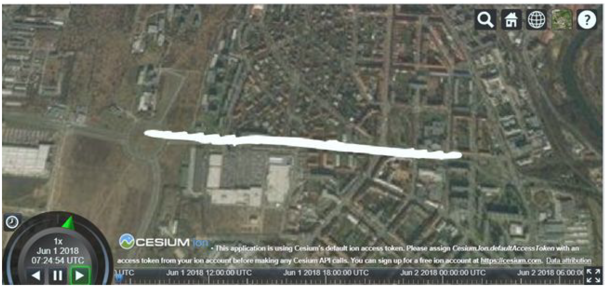
Interesting results were made in tasks derived from the Visualization of 3D data project. Visualization of temporal 3D data was tested and as well as CZML format data representation. Print screen of tested data set visualization is shown in next Fig 1.
Fig 1 – Visualization of 3D data in CesiumJS library
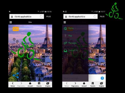
Several mock-ups and set of requirements for mobile applications were presented as results of tasks derived from the Define requirements and design mobile apps using open datasets project. One proposed mobile app was about gamification of evaluation of restaurants and cafés in France. Another mock-up was describing mobile app that is integrating bike rental services from different companies. This designed application was described up to the level of functionality and screens design as is shown in Fig 2.
Fig 2 – Screens of designed bike rental mobile app
Results of researches on availability of open data in selected countries or domains showed that the number of open data producers and publishers is increasing. Situation of open data was investigated in Latvia, France, UK and Spain.
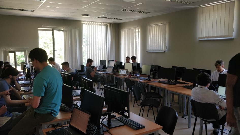
Students found this event attractive because it broadened their horizons in the field of modern technologies and datasets with emphasize in the spatial data domain. Students found this event attractive because it broaden their horizons in the field of modern technologies and datasets with emphasis in the spatial data domain. This event brought students an experience how to process tasks in different domains in limited time. Photo from a working and coding session during the Hackathon is shown in Fig 3.
Fig 3 – Coding and working session during the Hackathon
Programme
Wednesday 30. 5.
10:00 – starting of event, introduction of cooperating projects and project ideas
12:00 – introduction of students tasks
14:00 – start of coding
17:00 – wrap up results from first day, end of first day
Thursday 31. 5.
10:00 – start of second day, coding and working on students tasks
Thu 17:00 – wrap up results of second day, end of second day
We are pleased to invite to the third year of the INSPIRE Hackathon that is organised in the frame of the INSPIRE Conference 2018, 18-21 September 2018 in Antwerp, Belgium.
Registration is open. Create your own team or join an existing one and start working on your hackathon projects. The finale of the hackathon will be during the workshop at the INSPIRE Conference, 19th September 2018 at 2pm.
In 2016, the INSPIRE Conference hosted the first INSPIRE hackathon on volunteered geographic information and citizen observatories, also known as the INSPIRE Hackathon. The organisers, mostly representatives of European research and innovation projects, continued this activity with the next INSPIRE Conference in 2017. The INSPIRE Hackathon is a collaborative event for developers, researchers, designers and others interested in open data, volunteered geographic information and citizen observatories. The main driving force for the INSPIRE Hackathon is provided by experts from existing EU projects, and its primary objective is to share knowledge and experience between the participants and demonstrate to wider audiences the power of data and information supported by modern technologies and common standards, originating from INSPIRE, Copernicus, GEOSS and other initiatives. This paper describes the history and background of the INSPIRE Hackathon, the various INSPIRE-related hackathons already organised, supporting projects, the results of INSPIRE Hackathon 2017 and the authors’ vision of future activities.