Another Series of the INSPIRE Hackathon Webinars

The organisers of the INSPIRE Hackathon 2018 have prepared another series of webinars. These webinars include:

Wednesday 29 August 2018 at 2.30pm CEST on Open Data Portals & APIs

Thursday 30 August 2018 at 2pm CEST on Smart Points of Interest (SPOI) and Location & APIs – register at https://events.genndi.com/register/169105139238444764/cd48da7ab8

Friday 31 August 2018 at 2pm CEST on APIs for Security & CKAN – register at https://events.genndi.com/register/169105139238444764/64fb1571b3

A Report from the Valmiera INSPIRE Hackathon 2018

This is a report from one of the satellite hackathons organised in the frame of the INSPIRE hackathon series – The Valmiera INSPIRE Hackathon 2018.

Another event from the INSPIRE Hackathon series took place at the Vidzemes University of Applied Sciences (ViA) in Valmiera in Latvia between 30th May and 1st June 2018. The event was organized by the ViA in cooperation with several European projects namely DataBio, NextGEOSS, EUXDAT, PoliVisu and also in cooperation with the Plan4All association.

This Hackathon was focused on introduction of technologies and data sets used in cooperating projects to students of the ViA. The majority of participants of the Hackathon were 2nd year students of the Information technologies programme from the ViA. Students could choose tasks prepared by mentors before start of the event or they could come with own project idea.

Students’ tasks for the Hackathon were derived from following project ideas:

  • Visualization of 3D data using CesiumJS library;
  • Processing and visualization of sensor data;
  • Integration of available datasets to existing databases e.g. Smart Points of Interest (SPOI), Open Land Use (OLU) etc.;
  • Design mobile application using open datasets (SPOI, OLU, etc.);
  • Analysing and visualization of remote sensing data especially Copernicus datasets;
  • Define requirements and design mobile apps using some open datasets;
  • Research of available open data in EU countries.

Students were working on selected larger tasks in small groups or alone on particular tasks. Students were discussing issues with mentors and mentors were providing students advices during solution of tasks. Each participating student has presented results of selected task at the end of the event and gave certain feedback of utilization of recommended technologies and datasets.

Interesting results were made in tasks derived from the Visualization of 3D data project. Visualization of temporal 3D data was tested and as well as CZML format data representation. Print screen of tested data set visualization is shown in next Fig 1.

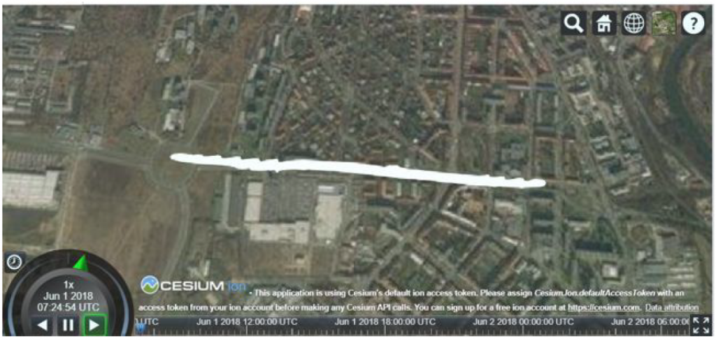
Fig 1 – Visualization of 3D data in CesiumJS library

Several mock-ups and set of requirements for mobile applications were presented as results of tasks derived from the Define requirements and design mobile apps using open datasets project. One proposed mobile app was about gamification of evaluation of restaurants and cafés in France. Another mock-up was describing mobile app that is integrating bike rental services from different companies. This designed application was described up to the level of functionality and screens design as is shown in Fig 2.

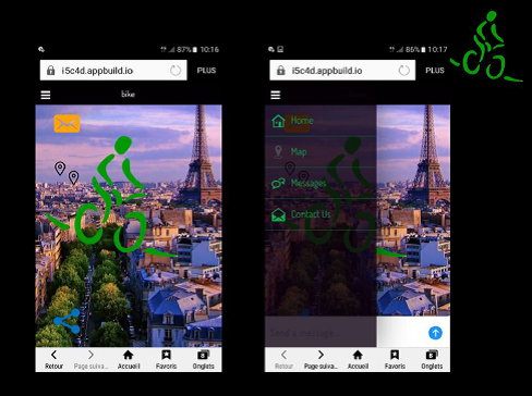
Fig 2 – Screens of designed bike rental mobile app

Results of researches on availability of open data in selected countries or domains showed that the number of open data producers and publishers is increasing. Situation of open data was investigated in Latvia, France, UK and Spain.

Students found this event attractive because it broadened their horizons in the field of modern technologies and datasets with emphasize in the spatial data domain. Students found this event attractive because it broaden their horizons in the field of modern technologies and datasets with emphasis in the spatial data domain. This event brought students an experience how to process tasks in different domains in limited time. Photo from a working and coding session during the Hackathon is shown in Fig 3.

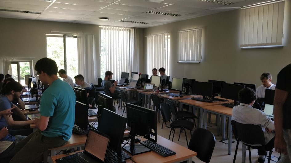
Fig 3 – Coding and working session during the Hackathon

Programme

  • Wednesday 30. 5.
    • 10:00 – starting of event, introduction of cooperating projects and project ideas
    • 12:00 – introduction of students tasks
    • 14:00 – start of coding
    • 17:00 – wrap up results from first day, end of first day
  • Thursday 31. 5.
    • 10:00 – start of second day, coding and working on students tasks
    • Thu 17:00 – wrap up results of second day, end of second day
  • Friday 1. 6.
    • 10:00 – start of students presentations
    • 13:00 – evaluating results, end of the event

Registration Opens for the INSPIRE Hackathon 2018

We are pleased to invite to the third year of the INSPIRE Hackathon that is organised in the frame of the INSPIRE Conference 2018, 18-21 September 2018 in Antwerp, Belgium.

Registration is open. Create your own team or join an existing one and start working on your hackathon projects. The finale of the hackathon will be during the workshop at the INSPIRE Conference, 19th September 2018 at 2pm.

More information at https://www.plan4all.eu/inspire-hackathon-2018/.


Webinar No. 3: Essential Biodiversity Variables and their metadata

Learn about the Essential Biodiversity Variables and their metadata. You’ll meet CKAN based data hub expert Wolfgang Ksoll, Biodiversity experts Stephan Hennekens and Elnaz Neinavaz, Marie-Francoise Voidrot from OGC and expert on standards, and Karel Charvat & Bente Lilja Bye from Plan4All and a number of H2020 projects!

TEAM 8: Exposing GUF Metadata as DUV in the GeoDCAT-ap Output of GeoNetwork

TEAM LEADER: Paul van Genuchten

TEAM MEMBERS: Looking for organisations that have GUF metadata (or other User Feedback on datasets)

PROJECT IDEA: In the scope of ‘ELISE tools’ the GUF (http://www.opengeospatial.org/standards/guf) schema has recently been added to GeoNetwork (https://github.com/metadata101/guf10). GUF allows to store User Feedback linked to datasets. W3C has released a DUV schema (https://www.w3.org/TR/vocab-duv) for User Feedback that links into DCAT. Goal of this project is to develop a DUV export of GUF as part of the GeoDCAT-ap export capability of GeoNetwork. And if feasible also create a schema.org/review output as part of the schema.org/Dataset annotations in the metadata HTML visualisation.

Webinar No. 1: ORLÉANS/OGC INSPIRE HACKATHON 2018

Plan4all in cooperation with OGC and several EU projects cordially invite you to the first webinar dedicated to the ORLÉANS/OGC INSPIRE Hackathon 2018.

Date: Friday, February 23rd

Time: 3pm CET

For more information and registration to the webinar, please visit the following page:

https://nextgeoss.lpages.co/introduction-to-orleans-ogc-inspire-hackathon/

TEAM 1: Easy-to-Use Satellite Images Discovery in a Map Viewer

TEAM LEADER: Tomáš ŘEZNÍK (Masaryk University/Lesprojekt/Wirelessinfo/HSRS)

TEAM MEMBERS: Šimon LEITGEB (Masaryk University/Lesprojekt/Wirelessinfo), Štěpán KAFKA (HSRS), Karel CHARVÁT (Plan4All/Lesprojekt/Wirelessinfo/HSRS), other participants are warmly welcomed

PROJECT IDEA: Discoverability of geospatial data and services (aka resources) has been considerably improved during the last decade as several catalogues have been developed, fulfilled with metadata and being in daily use for many users. Nevertheless, it means that a user typically works with her/his GIS system and opens a catalogue as a specialized application. Such paradigm may suit to geospatial experts.

On the contrary, a laymen expects one simple tool for maps viewing. (S)he does not like to bother with another application to discover which other geospatial resources are available for a currently zoomed area.

The aim of this team is therefore to develop an easy-to-use satellite images discovery integrated directly in a map viewer. We intentionally do not use the term ‘catalogue’ as (1) we would like to erase borders between data and metadata in our application and (2) we would like to retain catalogues in a way they are.

Relevant resources to a currently zoomed area will appear through links to satellite programmes’ APIs, such as Copernicus’ Open Access Hub. The developed application will be based on OpenLayers 4-based framework called HSLayers NG (see https://github.com/hslayers/hslayers-ng).

ORLÉANS/OGC INSPIRE Hackathon 2018 – Metadata

Plan4all and the Open Geospatial Consortium (OGC) in cooperation with the DataBio, NextGEOSS, PoliVisu and EUXDAT projects cordially invite you to the next satellite INSPIRE hackathon that will take place during the OGC Technical Committee meeting in Orléans (France) on 22nd March 2018.

More details at https://www.plan4all.eu/orleans-ogc-inspire-hackathon-2018/.