Webinar “Experience Tour of the SmartAgriHubs Regional Cluster Central Europe” 07.07.2020, 11:00 – 12:00 CET

The webinar will offer you a tour of the Regional Cluster Central Europe. From networking and community building, to innovative ideas, the right technological support to financial opportunities for growth and support, all perspectives are included in the regional cluster and presented in this webinar.

The webinar aims to introduce potential stakeholders to the ambitions and activities currently done by the Regional Cluster. Our goal is to inform participants and motivate them to join the cluster to co-design, co-develop and benefit from the potential offered by the SmartAgriHubs network. This includes technical innovations, networking opportunities as well as opportunities for financial support for digitalization projects in the agri-food sector.

A group of international experts in the field will give short insights in the different topics, thus facilitating further discussion and deeper exchanges.

Agenda and Registration

Agenda:

  • SmartAgriHubs Regional Cluster Central Europe: Ambitions and Activities
  • Setting up a Digital Innovation Hub (DIH): Introduction of technology usable for building a digital hub: basic functionality, frontend users, backend, tools, applications
  • Building a community for DIHs using Hackathons: Use case od DIH – example on the Kampala Hackathon and usage of the DIH SmartAfriHub.com
  • Innovation Experiments: ‘Autonomous Vineyard Mower’ and ‘site-specific management in practice‘
  • SmartAgriHubs Open Call: An opportunity to join the community
  • Questions and Discussion: Your chance to interact with us

Date and Time: July 7, 2020| 11:00 – 12:00 CET

Registration available at https://attendee.gotowebinar.com/register/4029595074860211981

The event is online. You will receive the webinar link as well as your access information from the webinar organizer via e-mail. Participation at the webinar is free of costs.

Event organizer: SmartAgriHubs Regional Cluster Central Europe through LKO (www.lko.at) and WirelessInfo (www.wirelessinfo.cz)

Questionnaire on Adoption of AgriSemantics for Food Security

Dear GODAN Partner,

Dr. Chris Baker from the New Bunswick University and Senior Data Scientist, and machine learning expert Dr. Brett Drury are conducting research on the adoption of AgriSemantics for food security. As part of this research they have developed a questionnaire and need the input of subjects who – like many of GODAN’s partners – work with agricultural data.

Please share the link with your networks, and with anyone you know may be interested in taking part: https://forms.gle/SsiKE2WF8si31aFK7

The results will form part of an upcoming publication on the topic. Find out more below.

Introduction

Agrisemantics allows the meaning of specific concepts in agricultural data to be clearly defined and understood by organisations who consume or produce data in the agricultural supply chain. This can be achieved with publicly available resources such as taxonomies, ontologies and thesauri which when created for agriculture are collectively referred to as Agrisemantics. These resources have been available for at least the last twenty years. The adoption of these resources by the agricultural sector has been limited and at best uneven in quality or performance. This study is designed to understand why the adoption of Agrisemantics is stymied.

Project Aims

The main aim of this project is to gain an understanding of the commonalities of adoption of Agrisemantics of all communities. From these common themes we wish to identify the drivers and roadblocks to the adoption of AgriSemantics in private industry as well as possible blindspots in the current development of publicly available resources. A secondary aim of this study is to publicise Agrisemantics to decision makers. The current COVID crisis has exposed the fragility of Agricultural Supply Chains. Agrisemantics facilities interoperability and has the potential to distribute the risk by allowing the ad-hoc integration of small suppliers into larger supply chain systems. This distribution of risk removes single points of failure in Supply Chains which are created by small numbers of large suppliers. However many decision makers are unaware of this. It is hoped that this study will raise awareness how Agrisemantics can benefit Agricultural companies.

Methodology

The research methodology uses in person interviews and a questionnaire to elicit opinions about:

  1. The adoption of AgriSemantics in private industry and the public sector
  2. The flaws in current AgriSemantic public resources.
  3. How does funding impede or enable AgriSemantic projects
  4. Is there any incentive for knowledge transfer from publicly funded projects to private industry.
  5. Is there any pressure from government agencies to force private industry to adopt standards.
  6. The measurable benefit of semantics resources and technologies to the targeted goals of researchers and business decision makers.

The interview process is a free form interview where the interviewee expresses their opinion about the core themes as well issues that they think is important.

The study is interested with interviewing people with the following profiles:

  1. Individuals who approve funding for AgriSemantic projects
  2. Individuals who have served on committees that set funding criteria for Agriculture
  3. Innovation projects
  4. Technical people who work with data integration on day to day basis
  5. Project Managers
  6. CEOs of AgriBusiness Companies
  7. NGOs who produce publicly available semantic resources
  8. Academics
  9. Technical professionals serving on committees tasked with the development of standards supporting interoperability.
  10. Agribusiness entrepreneurs
  11. Supply chain professionals

Study Outputs

The study aims to produce a high quality policy paper which seeks to influence all levels of the Agrisemantic, and Agricultural communities, and put Agrisemantics front and centre in the current debate about food security and stability of the food supply chain.

Code4Green Hackathon – “European environmental data hack”

German Federal Ministry for the Environment, Nature Conservation and Nuclear Safety announced a 36-hour Code4Green hackathon dedicated to environmental challenges namely climate change, biodiversity and circular economy challenges. The hackathon will be held virtually between 10 July and 12 July 2020.

With satellites, IoT sensors and environmental monitoring comes Big Data. Current solutions to environmental challenges are often fragmented due to the way this data is collected, especially across Member States. Finding solutions to assist in the timely and standardised collection of such data has never been this important.

“We are looking for teams to build open source prototypes using environmental data to build solutions for all of Europe. Our data-coaches and experts will be available to provide guidance, support, and inspiration. We will take care of the data preparation so you and your team can focus on bringing your innovative idea to life.”

The winning teams for all challenges will be provided with cash prizes of 10.000 Euro in total, three months of mentoring by industry experts to turn their prototype into a market-ready solution and potential funding possibilities, as well as a trip to Berlin in October to present their solution to the EU environmental ministers.

At a glance

When? 10 – 12 July
Where? Hack online at your computer
Topics and Challenges: #ClimateChange, #Biodiversity and #CircularEconomy – See below for details.

Applications close: 3 July – Apply now at: https://code4green.awardsplatform.com

For more information, please visit https://www.bmu.de/en/service/events/wettbewerbe/code4green/#c33199

Invitation to the Webinar on Metadata & Data Sharing and Management Principles

We would like to cordially invite you to the upcoming webinar dedicated to metadata and FAIR sharing principles for best practice in research data management that is scheduled on Tuesday 23rd June at 10 AM CEST.

During the webinar you will learn:

Metadata Introduction The importance of metadata is often underestimated. For data users are metadata commonly regarded as a necessary evil, and something mandatory to the data creating and dataset publishing process. This presentation offers a different point of view: metadata are a red line connecting the geographical tools and applications. No matter when searching for relevant data, Web services, explaining underlying models, displaying predicted situation in a map etc. This presentation will guide you a way to revoke an artificial border between data and metadata.

Predicting cloudness of satellite images through (meta)data Metadata does not have to be texts! Metadata in a textual way have in some cases a low information value for a user; e.g. a satellite image is covered from 60% by clouds. Will my farm be covered with clouds or not? This presentation will guide you through another (meta)data use case: metadata as geometry/graphics. Moreover, the presentation deals with cloudiness predictions as well as notification mechanisms through e-mail and SMS.

Micka MIcKa http://micka.bnhelp.cz/ is a complex solution for metadata management and for Spatial Data Infrastructure (SDI) and geoportal building. It contains tools for editing and management of metadata for spatial information, web services and other sources (documents, web sites, etc.). It includes their search on the Internet, portrayal in map or download to local computer. OpenMicka is freely available while Micka is a commercial tool. The designation (Open)Micka is used hereinafter for features similar to both licensing versions. Commercial version of Micka is also available free of charge for the duration of the SIEUSOIL project. The full documentation to both versions is stored at https://github.com/hsrs-cz/Micka . MicKa is now part of SmartAfriHub https://www.smartafrihub.com/cs/metadata

FAIR data principles for best practice in research data management The FAIR data principles identify four important characteristics of datasets (Findable, Accessible, Interoperable and Reusable) that will make them easier to use. These principles have been developed to help publishers assess whether individual datasets are published in a FAIR and open way. They have been adopted by the research community, where they capture a set of best practices that apply when publishing any type of dataset. FAIR data principles can be applied to data that exists at any point on the data spectrum. The principles emphasise clear licensing and recommend standard licences ‒ like those of creative commons ‒ but do not suggest data should be either closed, shared or open. For instance, sensitive personal data only available to researchers under limited data sharing agreements can still benefit from being FAIR to ensure researchers can easily find, access and reuse that data.

You will hear from:

The webinar is open to everyone – students, researchers, data analytics, NGO, African and European projects, anybody in Africa and beyond, who is dealing with data management.

Dubrovnik INSPIRE Hackathon 2020 Winners

Dubrovnik INSPIRE Hackathon 2020 was terminated by a final presentation of results and awards ceremony during the INSPIRE 2020 Online conference. The jury members including Jitka Faugnerová (CENIA), Stefano Tamascelli (XTeam Software Solutions) and Alexander Kotsev (JRC) announced the following winners of the Dubrovnik INSPIRE Hackathon 2020:

Congratulations to all the winning teams and many thanks for excellent work to all participants!

Dubrovnik INSPIRE Hackathon 2020 – Invitation to the final event

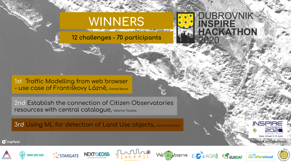
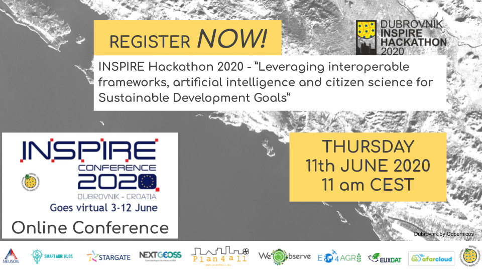
Dubrovnik INSPIRE Hackathon 2020 – ”Leveraging interoperable frameworks, artificial intelligence and citizen science for Sustainable Development Goals”

This is the fifth year of the INSPIRE Hackathon, an integral part of the INSPIRE conference and workshops. On Thursday 11th June 11:00 am CEST, the results from the hackathon challenges will be presented showing what the teams have achieved in the weeks of virtual collaboration. The workshop will conclude with an announcement of the top three teams in an awards ceremony. 

REGISTER for the event HERE Thursday 11th June 11:00 am CEST

The INSPIRE Hackathon 2020 is in line with the motto of the INSPIRE Conference – “Bringing sustainability and digitalisation together”. The hackathon is co-organised and supported by 10 partners: Plan4all, WeObserve, NextGEOSS, EO4agri, EUXDAT, Sieusoil, Stargate, SmartAgriHubs, AFarCloud, INSPIRE. The Dubrovnik INSPIRE hackathon organization is led by Plan4all and consists of 12 individual challenges this year.

Citizen science
The goal of the hackathon is to promote collaboration and sharing of experience in the domain of spatial data/services and citizen-science while showcasing their utilisation and uptake to different application domains and themes. This includes supporting the Sustainable Development Goals. The H2020 WeObserve project (https://www.weobserve.eu/) that aims to create a sustainable ecosystem for Citizen Observatories for environmental monitoring and improve coordination between related regional, european and international activities has been a main contributor. 

4 out of 12 challenges are addressing different aspects of citizen science data:

  • Integrating INSPIRE with Citizen Science and EO authentication systems
  • Establish the connection of Citizen Observatories resources with central catalogue
  • Improve interoperability between methods for sharing in-situ and citizen-sourced data
  • Interchangeable map compositions in support of collaborative spatial intelligence

Artificial intelligence
There is an increasing interest in developing digital ecosystems for the environment focussing not only on data and infrastructures but also on algorithms, analytics, insights and applications. Artificial intelligence is an area of technology that has great potential to support the Sustainable Development Goals, as any other area of society. In the Dubrovnik INSPIRE hackathon we have the following challenges related to AI.

  • Using ML for detection of Land Use objects
  • Deep learning for weather forecast

Sustainable Development Goals – Food Security
Food security is one of the Sustainable Development Goals that is easy to understand for us all. We all need food. Food security is global in nature because the agricultural sector and industry is global. The H2020 project EO4agri is collecting input for their policy advise to the EC for future development of agricultural infrastructure, data and platform requirements and more. The following challenges will provide valuable input to the EO4agri input as well as to the INSPIRE community.

  • EO4Agri Ideathon
  • Assessing phenological events (sowing/planting, emergence, end of season…) in agriculture based on Copernicus data
  • Copernicus and LPIS data combined in data cube services
  • Using Sentinel 1 data and IoT technology for analysis of soil moisture

Interoperable frameworks and open data
In general, the INSPIRE hackathons are all about promoting use of data, particularly open data from Copernicus and GEO, contributing to making the data interoperable following standards like INSPIRE, OGC, ISO etc. In addition to the SDG Food security we address also traffic and land use, both components in several SDGs. 

  • Traffic Modelling from web browser – use case of Františkovy Lázně
  • Extend OpenLandUse by selected Inspire Data Theme

Jury evaluation
More than 70 participants have contributed to these 12 challenges and their results are evaluated by an international experts jury.

Meet the jury members:

Jitka Faugnerova is the INSPIRE Member State Contact point for the Czech Republic in the Czech Environmental Information Agency, CENIA, where she is responsible for practical implementation of INSPIRE Directive: support for data providers, dissemination activities (organisation of technical and legislative workshops for INSPIRE stakeholders, coordination of public consultations to INSPIRE regulations) as well as for the transposition of INSPIRE Directive into the Czech law. She graduated from the Faculty of Civil Engineering of Czech Technical university. Jitka has had several commissions of trust related to the INSPIRE directive.

Stefano Tamascelli graduated from the school of Software Engineering of the Padua University (Italy) in 2000. I has obtained a PhD degree in Artificial Intelligence and Neural Networks from the University of Padua in 2003.  Stefano Tamascelli is the Managing Partner of XTeam Software Solutions, has designed and developed over 100 commercial products for Amiga, Windows, MacOs, Linux, Nintendo GameBoy Advance, Nintendo DS, Android, iOS, Flash, HTML5 and has worked on other projects/videogames as a consultant for Xbox, Xbox360, XBox One Playstation 2, Playstation 3,  PlayStation 4 , PlayStationVita, Nintendo3DS, Nintendo Switch. He has also lead all the research projects of the company, such as GeniuX Photo EFX (award-winning photo editing software), 3D GeniuX, Extender (augmented reality awnings for outdoor ), the Retaliation series for Forgotten Empires, The Ballad Singer and have a consolidated experience in H2020 projects with the participation on 6 projects ( 3D TuneIn, SCENT, PLUGGY, MCI, MCI2, Victor ).  Now he is  working on artificial intelligence for the dementia’s study and to improve the listen experience of people with hearing loss / cochlear implants.

Alexander Kotlev is an experienced researcher with a long track record of projects and research interests spanning across multiple domains such as IoT, citizen science, data interoperability, standard-based web services, spatio-temporal data and GIS. Alex joined the JRC in 2012 where he is working on the technological enablers for data-driven innovation across multiple domains and levels of governance. Alex has hands-on experience in the use of open source and proprietary ETL tools, digital mapping technologies, spatial databases, Python and OGC Standards. He has a strong education background and holds a Doctor of Philosophy in GISCience (Ph.D.)

REGISTER for the event HERE Thursday 11th June 11:00 am CEST

RDA Global Adoption Week: 15-19 June 2020

The adoption session, originally planned for Plenary 15, is now turning into a global adoption week scheduled from 15 to 19 June 2020. The aim remains to demonstrate the wide variety of adoptable and adopted solutions to data sharing challenges that people in the field encounter in their daily jobs.

The global adoption week will provide the opportunity to learn about RDA Outputs, converse with speakers from all around the world who have created and implemented them, and determine how best to integrate those data sharing solutions into your own projects. The global adoption week will be organised around five Research Data Lifecycles, as used in the RDA recommendations and outputs catalogue.

  • Monday June 15: Data Management
  • Tuesday June 16: Data Description
  • Wednesday June 17: Identity, Store, and Preserve
  • Thursday June 18: Disseminate, Link and Find
  • Friday June 19: Policy, Legal Compliance, and Capacity

Pick your session and register here: https://www.rd-alliance.org/rda-global-adoption-week-15-19-june-2020

Dynamic Visualisations for Analysing Road Accidents and Traffic Conditions

REGISTER HERE

Modern data analysis often requires special techniques for handling complex data structures. Interactive graphs can provide insights into multivariate datasets by communicating the key aspects in a more intuitive way than isolated bar charts or static maps.

This webinar will present the WebGLayer tool as an enabler of dynamic visualisations that make spatio-temporal patterns, relationships and trends in the underlying data more apparent. Using case studies from Pilsen (CZ) and Flanders (BE) we’ll show how policy makers can use WebGLayer to address local problems such as traffic congestion and road accidents.

Others who might find this event useful include web developers, Open Source enthusiasts, social scientists, journalists and civil society groups interested in exploring social issues through data visualisations.

You will hear from:

Even if you can’t join live, register now and we’ll send you a link to the recorded webcast to watch at your convenience.

115th OGC Technical Committee meeting: Invitation to EO4Agriculture session

During 115th OGC Technical Committee meeting which will be held virtually there will be a session EO4Agriculture by Agriculture DWG. The session will be focused on standardisation of EO information for farming sector and food sector. It will include also analytical possibilities like AI.

The EO4Agriculture session will be held on June 15th, 10:00 AM – 11:30 AM EDT (Room D)

Indicative program:

  • Karel Charvát (Plan4all)– EO4Agri analysis
  • Maximilien Houël (Sistema Gmbh) – Creation of a vegetation index using Sentinels data and machine learning methods: monitoring of the desert locust impact.
  • Filip Leitner (MUNI) – Predicting cloudness of satellite images through (meta)data
  • Pavel Hájek (Plan4all) – Climate Change Trends for Africa
  • Vojtech Lukas (Mendelu University), Karel Charvát Jr. (Lesprojekt) – Preparation of application maps for precision farming
  • Antonella Catucci (E-GEOS) – PREMIA: Platform for Risk Evaluation and Management in Agriculture

You don’t have to be an OGC member to attend an OGC meeting. This session is open to anyone to attend and new voices are always welcome.

You can access the meeting on  https://www4.gotomeeting.com/join/329153333

REGIONS MATTER FOR INNOVATION, AND INNOVATION MATTERS FOR REGIONS

We are happy to share with you the International Newsletter of our partner Vidzeme Planning Region, where latest achievements and activities are listed.

The newsletter is avilable HERE.

Since Vidzeme Planning Region (VPR) has started implementing international projects, an extensive cooperation network has been developed, which includes 232 partner organizations in 28 countries. The considerable number of contacts has allowed us to successfully implement projects, use access to extensive knowledge and experience to implement it all with the financial support of the European Union (EU) in Vidzeme region.

Innovation in Vidzeme has a special role and it has become a core element of the regional development agenda.

Simply regions matter for innovation, and innovation matters for regions. Also in Vidzeme, every idea that is planned or implemented brings with it the desire to innovate, bring new winds, strive for excellence and uniqueness, but at the same time putting people at the center.

  • Vidzeme Innovation Week was organized for a second time this February, and it is truly growing into a platform for networking, for sharing, for learning.
  • Vidzeme Planning Region is working as one of seven Transnational Innovation Brokerage System points, where individual, tailored solutions for companies, willing to innovate and internationalize are supported.
  • An action plan for knowledge-driven bioeconomy innovation ecosystem in Vidzeme Region is finalized, and first activities already delivered.
  • Cluster, co-founded by us already years ago, has transformed into a Latvian Food Bioeconomy cluster.
  • Transport-on-demand solution is piloted in our region, and it has gained a great feedback from local inhabitants.
  • Solutions in energy efficiency have been introduced to the local municipalities, schools, companies and society.