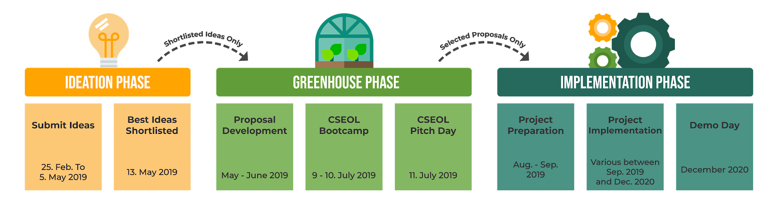
There will be a series of webinars – one webinar for each of the 9 teams of the Nairobi INSPIRE Hackathon 2019. In these webinars you will learn about the topics addressed, get an overview of the planned work, and of course discuss the first rounds of ideas.
This is a description of Team no 8 of the Nairobi INSPIRE Hackathon 2019 led by Uta Wehn as a mentor and assisted by Raitis Berzins and Simon Leitgeb.
From “We cannot manage what we cannot measure” to “Let’s measure together!”
Effective environmental management – including day-to-day, hazard and crisis management – is dependent on effective environmental monitoring. But monitoring over large areas in-situ often requires higher levels of capacity than monitoring bodies have. At the same time, those measurements that we can get over large areas – the Earth Observation data coming from satellites – may need in-situ validation in order to provide sufficiently predictive models for meaningful management. Again this can require very high levels of capacity. In both cases, Citizen Science (CS) has already emerged as a potential solution, as exemplified by projects such as beAWARE, Ground Truth 2.0, and a whole range of innovation initiatives – including INSPIRE’s hackathons.
But while the potential for CS is enormous, in practice its implementation (in terms of stakeholder engagement, data interoperability and user-driven app development), its uptake by decision-makers and its integration into mainstream science, are faced by a range of social, scientific, technical and economic challenges. Team 8 will explore these various challenges and generate a wide range of ideas on how sound CS can be used to validate and utilise data from satellites. Experts in the team on the social as well as technical aspects of CS will help groom initial ideas, support app development, and promote the combination of data from various sources, etc.
Not only that, but while the INSPIRE hackathon itself is not a competition, there is the possibility across all the hackathon Teams to channel great ideas to the CSEOLab process for the chance to win ESA-funding and CSEOL project support for pilot projects. So let’s explore how we can seize the innovative potential of Citizen Science to measure, monitor and manage our environment!
This is a description of Team no 2 of the Nairobi INSPIRE Hackathon 2019 led by Karel Jedlicka as a mentor and assisted by Karl Gutbrodt, Pavel Hájek, Jiří Valeš, Vojta Lukas.
This team aims to demonstrate several options of meteorological data exploitation for the needs of African farmers. The farmers needs were collected and are described in the Vaughan et al. (2017) study:
As there are many options for exploitation, the team focuses on two use cases. The first one is focused to historical weather data and the second one is related to weather forecast data.
The first use case focuses on evaluation of a suitability of a region for particular crop type – based on climatic data. In particular, Kenya, as the conference hosting country, is selected as the area of interest and maize is selected as the crop.
The goal is to categorize Kenya countryside to regions according to a suitability of maize production, based on Earth observation data and ideally compare it to the real situation in the region. The categorization will be done according to the temperatures and ideally also soil moisture data from last 40 years, looking for areas where there is:
a period of 130 days with temperatures between 10°C – 30°C,
soil moisture is above a certain value (need to be defined) in the middle of the period.
The second use case leverages weather forecast data to predict a probability of insect pest threat to crops. The idea lies in a calculation of cumulative effective temperatures needed for development of “armyworms” (Spodoptera exempta and Spodoptera frugiperda) to grow. As the effective temperatures are calculated from the forecast data, a risk ratio can be calculated in advance and alerts can be sent to farmers via cell phone when needed.
The team is experienced in meteorology, agronomy and geomatics. However, we are looking for new team members as there are:
open questions mainly related to local meteorological and agricultural conditions which differ from our Eurocentric experience,
opportunities to work with Earth observation and meteorological data.
The details about our work plan are going to be revealed at the upcoming webinar. Then a Skype based cooperation of the team will take place.
Acknowledgements:
European e-Infrastructure for Extreme Data Analytics in Sustainable Development (EUXDAT). H2020: EINFRA-21-2017, no.: 777549. www.euxdat.eu
Research and development of intelligent components of advanced technologies for the Pilsen metropolitan area (InteCom), by the Czech Ministry of Education, Youth and Sports CZ.02.1.01/0.0/0.0/17_048/0007267 [CZE: Výzkum a vývoj inteligentních komponent pokročilých technologií pro plzeňskou metropolitní oblast (InteCom). EU, Operační program pro výzkum, vývoj a vzdělávání. MŠMT CZ.02.1.01/0.0/0.0/17_048/0007267]. https://ntis.zcu.cz/cz/o_centru/resene_projekty/
Aggregate Farming in the Cloud (AFarCloud). H2020 ECSEL JU, no.: 783221. http://afarcloud.eu/
PUNTIS, Project LO1506 of the Czech Ministry of Education, Youth and Sports.
This is a description of Team no 6 of the Nairobi INSPIRE Hackathon 2019 led by Raul Palma, Esther Dzalé Yeumo, Runar Bergheim, Karel Charvat as mentors.
New digital technologies including Internet of things, big data, artificial intelligence, robotics and Earth observation are changing agriculture and moving agriculture to more information demanding. This requires sharing of data between different stakeholders in agri-food chains (farmers, service providers, advisors, food industry, machinery producers, etc). This doesn’t mean that all this data have to be open. Sharing data is not necessary opening all of them, part of the data can be available for certain groups of members in the chain and under restricted conditions.
The problem of sharing and exchanging data in agriculture has been studied for a long time. Such process is very labor intensive due the fact that most parts have either to be executed manually, and/or require farmers use different tools to manage monitoring and data acquisition on‐line in the field. The focus of this team will be on the following topics:
Identify potential open data available for African farmers
Cataloging available open data in a metadata system
Analyse differences in sharing and opening data in the context of African agriculture
Discuss potential standards feasible for African agriculture
Discus existing data models, and how these models can fit for Africa
Demonstrate possibilities of linked open data and linked data in the African agriculture context
This is a description of Team no 5 of the Nairobi INSPIRE Hackathon 2019 led by Jiri Kvapil, Petr Uhlir and Karel Charvat as mentors.
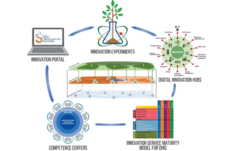
Digital Innovation Hubs (DIHs) ensure the connection between the ICT and the farming communities by bringing together IT suppliers, the farming sector, technology experts, investors and other relevant actors. This leads to new applications that are adapted to the real needs of farmers. National and regional authorities can play a key role in encouraging the setting up of DIHs and the creation of a regional innovation ecosystem.
The intention of this team is to develop a social space for African agriculture where farmers, the industry, research community, advisory services and others will be able share their knowledge, needs and experience.
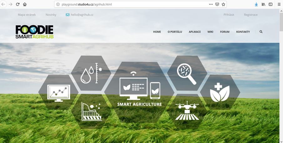
The starting point will be the WirelessInfo DIH, which is now developed in the Czech Republic in the frame of the SmartAgriHub project. We would like to invite different stakeholders, we are also looking for people ready to share their open research materials.
The tasks for this team are as follows:
Define a visual identity for the Agriculture Innovation Hub for Africa
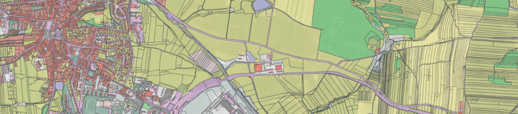
Many developing countries face problems related to poor spatial planning practices resulting in uncontrolled deforestation, grazing and urbanization occur. In order to mitigate these processes, it is essential to have in place data-based evidence and legal frameworks.
An important part of any planning processes is land use. And this is the key focus of this project to create an open land use database. During the hackathon the team will identify available data sources including Sentinel imagery. Following the methodology for creation of Open Land Use map developed within the SDI4Apps project, the team will extend the coverage of the existing Open Land Use map by several African countries.
As a result, there will be a prototype of a web application for collaborative creation of spatial plan based on the available data. Citizens will have a chance to update the open land use map and verify the classification of land use calculated from the Sentinel imagery.
Anyone interested in this topic from the African communities and experts focused on land use classification, design, web and app development are welcome to join this team.
EOVALUE is launching an open call for development of innovative applications integrating openly available datasets (incl. space and on site observations) and/or on-line services, adding value by creating new variables or indicators to support the EuroGEOSS initiative and in particular the Sustainable Development Goals or the Sendai Framework for Disaster Risk Reduction, or the Paris Agreement on Climate Change. Other areas of application will be considered providing they address broad environmental or social themes across geographic scales.
The Awards
The 20 best applicants will be awarded contracts by the JRC for a maximum of € 13.500 to develop the applications further, and take them to the stage of first public release within 3 months of signing the contracts. The winners will also be invited to present their applications to a dedicated international event co-organised by the European Commission. This will give visibility to the winning teams and provide opportunities for further development. Travel and daily allowance will be supported by the European Commission for 1 person from each winning team.
Deadline for submitting application concept, prototype, or user story (e.g. as document, slide presentation or video): 30 March 2019.
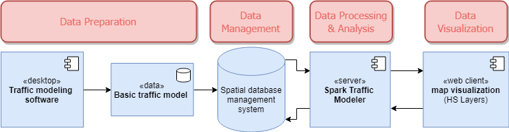
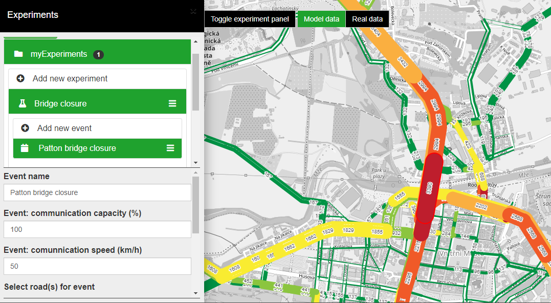
The goal of our team is to demonstrate how interactive traffic modelling can improve traffic situation in any city. The demonstration consist in gathering freely available / open source data and deploy a traffic modeller tool to Nairobi.
The planned workflow of our solution is as follows:
gather sufficient data about traffic network and about simulated traffic generators,
calculate traffic model and import it into spatial database, where it can be accessed by our traffic modeler.
this model will be then used for modeling specific traffic scenarios via traffic modeler’s Application Programming Interface (API) (see the image below).
The final step is to develop web Graphical User Interface (GUI) similar to one already in action for the PoliVisu pilot city – Pilsen (see the image below). This application allows users to calculate various traffic scenarios (i.e. change free flow speed/capacity of road segment) in near real time via only web browser with network connection.
Food security initiatives – food and nutrition security and sustainable agriculture are still major global challenges as reflected in the United Nations (UN) Sustainable Development Goals. According to the UN Food and Agricultural Organization (FAO), 80% of crop production growth in developing countries will come from higher yields, increased crop intensity and expanding land use. Existing food security related services focused on global agriculture monitoring. As an example, we can mention the GEOGLAM FAO activity.
The goal of this team is to analyse ways how Earth Observation technologies can help farmers and all communities at local and regional levels for more sustainable agriculture and food security. We will analyse several examples, good practices and ideas, potential applications, market etc. The goal is not to transfer European solutions to Africa. The goal is to find relevant solutions for Africa. We plan to collect ideas through questionnaires, share common working place and eventually run also some practical tests. Register yourself into our group and help us search for best solutions.
This is a description of Team no 7 of the Nairobi INSPIRE Hackathon 2019 led by Otakar Cerba, Raul Palma and Karel Charvat as mentors.
The goal of this team is to publish selected spatial open data from Kenya and other African countries as 5-star Linked Open Data (LOD). The datasets will be transformed and integrated into the Smart Points of Interest (SPOI) data model. The data model for SPOI was designed during the SDI4Apps project and provides a universal exchange approach to publish point based data in RDF format according to the the linked open data (LOD) principles.
Methodology:
Analysis of Kenyan data from the perspective of SPOI (occurrence, original resources, types of objects).
Searching and describing selected datasets.
Harmonisation of data to the SPOI data model (development of scripts and harmonisation pipelines based on web services).
Validation and evaluation of harmonised data.
Further development of SPOI related mobile apps for Kenya/Africa