SEMINAR: Use of sensor data in practice

(introduction of pilot applications not only in the Pilsen region)

The seminar takes place on April 28, 2022 in the Úhlava Education Center, o.p.s. in Klatovy, Plánická 174

Program:

9.00 – 9.10 Opening and welcoming of participants – Úhlava, o. P. S.
9.10 – 9.30 Presentation of the project MANDOLIN and DIH – World – Tomáš Mildorf and Kristýna Čerbová, Plan4all z.s.

Working with satellite data

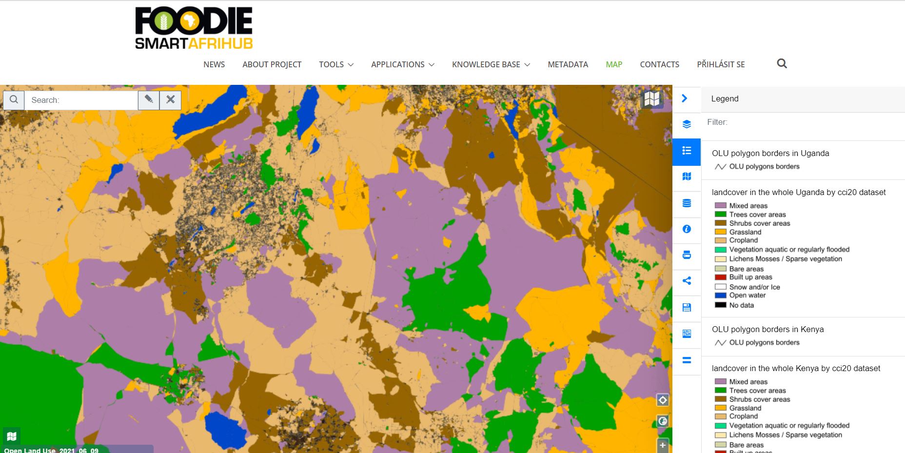
9.30 – 9.50 Sentinel 2 and Sentinel 1 data processing for agriculture (What data can bring us, what are the problems and benefits) – Heřman Šnevajs and Karel Charvát, WirelessInfo
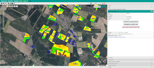
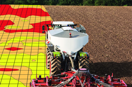
9.50 – 10.00 Generate your own zones – Jan Macura, Wirelessinfo / Dmitrij Kožuch, Plan4All z.s.
10.00 – 10.15 How to ensure the sharing and sale of satellite products using blockchain technology – Jiří Kvapil, Lesprojekt – služby, s.r.o.
10.15 – 10.45 FarmINSIDER – a platform that integrates research results and methods into an application for end users – Karel Charvát jr., Lesprojekt – služby, s.r.o.
10.45 – 10.55 coffee break

Working with sensors

10.55 – 11.10 Presentation of used solutions in agriculture and food transport – Jaroslav Šmejkal, Lesprojekt – služby, s.r.o.
11.10 – 11.30 Hardware solutions in agriculture and food transport – Agronode and Teltonika – Marek Musil, Czech Open Solutions Center spol. s r.o. and Jaroslav Šmejkal, Lesprojekt – služby, s.r.o.
11.30 – 11.40 Senslog – solution for sensor data collection – Michal Kepka, UWB in Pilsen
11.40 – 12.00 Applications for working with sensors (IE20, Dashboard) – Michal Kepka, UWB in Pilsen
12.00 – 12.20 refreshment break

Support for local sales

12.20 – 12.35 Regional specialties and Atlas of regional specialties – Petr Horák, WirelessInfo
12.35 – 12.45 Sales of regional specialties (e-shop) – Radana Šašková, Úhlava, o.p.s., and Tomáš Zelený, Šumavaprodukt, s.r.o.
12.45 – 13.00 What’s next? – Karel Charvát WirelessInfo

The seminar is intended for owners, managers and other managers and organizational staff of agricultural enterprises, producers and distributors and food trade workers with their own logistics. Due to the current pandemic situation, some contributions may be presented online.

Please do not forget to register to participate.

The seminar is held with the financial support of the DIH-World project funded under the European program H2020, grant agreement No. 952176

Hub4Everybody Webinar is coming up!

Do you have digital maps piling up on your computer? For example, results of student work, feeling maps of locations, results of field surveys or scientific experiments? Do you want to publish, promote or discuss the results of your activities across different target groups?

The answer to your requirements is Hub4Everybody, a system for publishing and sharing geographic data, which will be the focus of this webinar and you are cordially invited!

The webinar is scheduled for tomorrow (Friday, 22nd April) at 10 AM CEST.

You can join the webinar for FREE via following link:

Join Zoom Meeting
https://us06web.zoom.us/j/86267547479?pwd=bmlybGRFaXY5ZStkN3NPb2l0WlphUT09

Invitation to Hub4Everybody Webinar

Do you have digital maps piling up on your computer? For example, results of student work, feeling maps of locations, results of field surveys or scientific experiments? Do you want to publish, promote or discuss the results of your activities across different target groups?

The answer to your requirements is Hub4Everybody, a system for publishing and sharing geographic data, which will be the focus of this webinar and you are cordially invited!

The objective of this webinar is to introduce a technological solution Hub4Everybody, a basic technology for two challenges defined for the Agrihub INSPIRE Hackathon 2022: Challenge #9 A new social space for geographic information sharing and education and Challenge #12 Building a map based social space for Africa

The webinar is scheduled on 22/04 at 10 AM CEST.

Registration for the webinar is FREE. Register yourself via this link.

Agrihub INSPIRE Hackathon 2022: Challenge #16 Analysis, processing and standardization of data from agriculture machinery for easier utilization by farmers

MENTOR: Pavel Gnip

Agricultural machinery significantly influences the economic profitability of crop management. How to operate machinery on the field and achieve the best result in farming business? Data collection from running machine in time and location or Meteo sensor on the field can be one of basic controlling for farmers.

Ambition of the challenge

The ambition of the challenge is to prepare tools for quick overview on field data created by machine on the field by selected task for farmers overview and next decision making. Data view and next processing to combine those data with other farm’s data (sensors, labs, other) or open source data for farm practise reason.

Next steps

Verification, data controlling and visualization will be in first step, next step will analyze data with focus on:

  • Evaluation of the economic efficiency of machinery operations within the fields – farm
  • Precise records of crop management treatments
  • Management of machinery operations – increasing the efficiency of planning of crop management
  • Control of requirement for field operations:
  • Control of pass-to-pass errors and overlaps, coverage of maintained area and recommended work speed
  • Control of applied input material in comparison to prescribed rates
    • On line monitoring of weeds
    • On line monitoring of weather
  • ISOxml file from tractor offline
  • ISOxml file from tractor online

The registration for the challenges is open! Register for this hackathon challenge HERE.


Agrihub INSPIRE Hackathon 2022: Challenge #9 A new social space for geographic information sharing and education

MENTORS: Otakar Čerba, František Zadražil, Marketa Kollerova

We will test a new environment, where the editorial system will be the key unifying element of the geographical data processing. It will enable the creation of a web portal and also provides a natural connection to other parts of the system. The content management system is based on the Wagtail CMS (Content Management System) platform with the CodeRed CMS extension, see https://wagtail.org and https://www.coderedcorp.com/cms. This is one of the leading open source CMS used by small and large organizations (e.g. Google, NASA, British NHS). Wagtail is based on Django and the main development language is Python. It allows easy extension of functionality in the form of widgets, page templates, as well as permissions or other system parameters. It is therefore possible to integrate with others. This CMS is now integrated with tools supporting easy generation of map context.

This shows the connection of powerful Open Source mapping framework HSlayers, which supports visualization of maps.

Introduction/Context

The content of the challenge will be:

  • to test, how people can develop, publish and share their own maps using Web clients or desktop open source tools
  • to learn how to build nice map composition
  • to build own maps describing specific places or local problems

Ambition of the challenge

  • Support effective reuse of existing data
  • Build new data content
  • Promote regions
  • Prepare new type of educational content

Next steps

Part of planned activities will also be focused on the integration of new tools like IoT tools, dashboards and analytical tools.

The registration for the challenges is open! Register for this hackathon challenge HERE.

Agrihub INSPIRE Hackathon 2022: Challenge #12 Building a map based social space for Africa

MENTORS: Akaninyene Obot, Marketa Kollerova

During last year’s INSPIRE Hackathon the SmartAfriHubs Digital Innovation Hub (https://www.smartafrihub.com/cs/home) was developed. Moreover, there was a community built around it, which is now active on WhatsUp and Facebook. We would like this Hackathon to test possibilities of an extended environment, which will be more user friendly and which will allow large active sharing of information by users. It will not be focused only on publishing new maps, but also on developing content in the form of storyboards, producing active content from Africa, using of this content for better training and education, but also supporting sustainable development in Africa. We plan to extend the current community and increase visibility of this solution. There will be all data, which are currently stored on SmartAfriHubs available at the disposal of the hackers, moreover tools for easy data publishing and management, but also tools to develop storyboards and present actively different content connected with map information.

New solution, which is now under development, will be tested with different users. Current platform has architecture according new scheme:

This solution will be available on the Plan4all cloud and will be fully operational.

The basic unifying element of the geodata processing system will be  the editorial system. It will enable the creation of a web portal and also provides a natural signpost to other parts of the system. The content management system will be  based on the CodeRed CMS – https://www.coderedcorp.com/cms/ (Content Management System). This is one of the leading open source CMS used by small and large organizations (e.g. Google, NASA, British NHS). Wagtail is based on Django and the main development language is Python. It allows easy extension of functionality in the form of widgets, page templates, as well as permissions or other system parameters. It is therefore possible to integrate with other systems used within the organization (city geoportal, etc.) if such a requirement arises in the future.   It is now connected with tools, which are already part of SmartAfriHub. The goal is to help different groups of people to build their own content (maps, text, storyboard and others and share it with the community.https://www.coderedcorp.com/cms/

We would like to discuss additional extensions of the system about new functionalities.

Introduction/Context

The Hackathon will have few steps, which we would like to realize:

  1. Training of participants, how to use single components and how to generate own context and also training about currently available data
  2. Definition of limited numbers of use cases and build a team, who will prepare full context and prepare attractive publication of this context
  3. Implementing of context
  4. Sharing of experiences from use cases and suggestion of improvements
  5. Preparing final presentation and plan for future sustainability

Ambition of the challenge

The main challenges are:

  • to help African students and other people generate own content in attractive from
  • to promote sustainability in African regions
  • to generate new data
  • to provide large scale awareness towards African communities
  • to support future business
  • to prepare scientific publications

Next steps

The main next step is to make new solutions self-sustainable and form a social space, including a broader community, which will help to introduce new technological concepts in Africa, to support capacity building, and generate new data using principles of citizen science.

Another important point is to define future development priorities.

The registration for the challenges is open! Register for this hackathon challenge HERE.

Agrihub INSPIRE Hackathon 2022: Challenge #1 Further development and testing of the application for creating application maps

MENTOR: Karel Charvát jr.

Introduction/Context

Variable rate fertilizer application (VRA) is one of the ways to reduce fertilizer consumption, increase the efficiency of fertilizer use and reduce the environmental burden. The method is based on monitoring the in-field variability of crop status or soil properties. This variability can be detected or estimated in various ways, and the result of this effort is the creation of a Management Zones map. Management Zone represents an area within the field where the same intensity of growing operation will be used. When we assign a fertilizer rate to each Management Zone within a field, we get an application map that is ready to be exported for use in agricultural machinery.

The web application that will be the subject of this challenge uses yield potential (production zones) to define Management Zones and VRA maps. The yield potential is an estimate of the long-term yield variability within the field.

Ambition of the challenge

The web application (FarmInsight) currently allows farmers to manage their field data, manually plot an application map based on underlying data such as a rough yield potential 

map, or order a manually corrected Yield Potential calculation for selected fields and import them as Management Zones for the application map.

The calculation of yield potential maps is partially automated but requires some manual steps.

The goal of this challenge  is to propose concepts for extending the possibilities of automatic import of management zones from other sources such as automatically calculated yield potential zones (Challange 11), or general management zones based on indicators other than yield potential.

Testing this application on data from different farms and getting feedback will be part of this challenge.

Next steps

In this challenge we will work with a web-based application for the preparation of VRA maps.

The first version of this application was created within the Horizon 2020 project databio and has been further developed since then. In the near future, the application will be operated and offered to farmers and other users under the name FarmInsight.

We will mainly use the following data:

  • LPIS blocks from a continuously updated database,
  • vegetation indices and other satellite data,
  • calculated yield potential data.

The main objectives of this call are:

  • Testing the application using data related to several farms
  • Developing concepts for the use of Management Zones from other sources.

The registration for the challenges is open! Register for this hackathon challenge HERE.

Agrihub INSPIRE Hackathon 2022: Challenge #11 Automatization of calculation of management zones based on Yield potential

MENTOR: Jana Seidlová, Heřman Šnevajs

Rapidly rising input prices are forcing farmers to save on fertilisers and use them as efficiently as possible.

Fertilizers Price Index, 21st March 2022, source: https://ycharts.com/indicators/fertilizers_index_world_bank 

The most sensible response to rising fertiliser prices is precision agriculture based on variable approach to field. Replacing a uniform rate for the whole plot with a variable rate that takes account of the specific requirements of the site is of the greatest importance. Appiximately 8% of fertilizers are saved when the Variable Rate Application approach is used (a case study). Most of the machinary used by farmers is capable of applying variable rate of fertilizers automatically based on a prescription-application map.

Unsupervised classification of the farm fields automatically detects field borders

The first prerequisite for calculating management zones is true field boundaries. Incorrect field boundaries lead to unusable outputs. Although there is a freely available LPIS in the Czech Republic, some of the boundaries do not correspond to reality, and so multiple crops are grown on one plot. Crop detection allows the identification of plots where multiple crops are grown and their


An example of an application map, source: Variable Rate Application of Herbicides for Weed Management in Pre-and Postemergence

Application maps can be created based on vegetation indices derived from satellite imagery. Yield potential is a layer of relative index values on a plot over the last eight years. This provides resilience against single-year extremes.


Relative yield potential, source: QUO VADIS PRECISION FARMING

The missing link in the chain is the rapid process of creating management zones from the yield potential layer. The farmer then simply assigns a fertiliser rate to each zone and an application map is created. 


Variable Rate Aplication based on application map, source: https://www.farmmanagement.pro/the-return-of-variable-rate/ 

We work with several farms, which allows us to compare research results with the real situation and apply them in practice. 

The goal of this challenge is to automate the process of creating management zones from the yield potential layer, which would make variable fertilizer application significantly more affordable due to its accuracy and speed of creation.

The registration for the challenges is open! Register for this hackathon challenge HERE.


Agrihub INSPIRE Hackathon 2022 starts with the Challenge #10 Integrating QField with the Innovation Hub

MENTOR: František Zadražil

Geodata processing workflow tools have been developed in the last few years that offer anyone a chance to publish and share data with coworkers or a large community. All those tools are based on open source technologies and are designed to allow working with the data on desktop and web platforms. Components included in the workflow are:

A mobile application has been introduced to the workflow recently in the form of QField (https://qfield.org) and its derivatives. QField is based on the same libraries as QGIS Desktop is and targets at the in field work and collecting of data.

It is possible to publish single layers or whole map projects (compositions) to Layman. This challenge deals with the latter. All the mentioned components use an unified map composition schema to describe the map completely (https://github.com/hslayers/map-compositions). QField (and QGIS), on the other hand, uses its proprietary format for map projects and there are two ways to synchronize map projects from QGIS to QField. Copy the project directly from computer to the mobile phone or through the QField Cloud.

Main goal of the challenge is to add an option to publish existing Layman map compositions to the QField Cloud and make them available for the QField app.

The initial idea of the challenge is to

  • integrate QField to the geodata publication workflow on the level of map projects
  • transform map composition as Layman uses it to the QField Cloud project
  • store map projects in QField Cloud with the use of its API
  • Notes & remarks
    • Could some existing parts of the QGIS Layman plugin be used to do the transformation?
    • Add option to publish map composition to the Cloud instead of just Layman
    • The biggest challenge will be to unify the authentication and authorization of the current workflow (with Wagtail CMS at its core) with the authentication used by QField Cloud.

Ambition of the challenge

Integrate QField to the geodata publication workflow on the level of map projects so users can easily publish maps from existing tools to the QField Cloud and have them available in QField based  mobile apps.

Next steps

  • Host QField Cloud at our server
    • That would require solitaire QField based app (like already existing VRA Helper) to be able to connect to our own instance of Cloud
  • Authentication process will most likely require more effort than just this hackathon.

The registration for the challenges is open! Register for this hackathon challenge HERE.

OLU4Africa nominated for the WSIS Prizes 2022

It’s our pleasure to inform you that Open Land Use for Africa (OLU4Africa) map composition developed within the several INSPIRE Hackathons has been nominated for the World Summit on the Information Society Prizes 2022!

The development of the OLU4Africa dataset started during the Nairobi INSPIRE Hackathon in 2019 by exploring open data sources that could be used to build OLU4Africa. Efforts continued immediately the following year with another African INSPIRE Hackathon, the Kampala INSPIRE Hackathon 2020. That’s when the first land use map of the East Africa region was created. Since then, the dataset has undergone further development in the Open Spring INSPIRE Hackathon and its development will continue even this year during the upcoming – AgriHub INSPIRE Hackathon 2022. The team behind the development of OLU4Africa consists of participants from Uganda, Kenya, Nigeria, Ethiopia, Zambia, Egypt and Tanzania.

The main objective of OLU4Africa is to build an open seamless harmonized vector multipurpose and multilayer land use and land cover map of Africa from available open data sources. OLU4Africa is based on the simultaneously developed OLU data model version 2. Land cover and land use themes are important for many human activities and actions, while their availability and up-to-date validity is a very important aspect. OLU4Africa is being populated by datasets from African regions such as the Africover project and CCI Land Cover 2016 and newer, which has done the land cover mapping of particular African countries. Then, it was possible to use other tags from the OpenStreetMap to identify land use except for the ‘landuse’ tag. For example, ‘natural’, ‘amenity’, ‘leisure’ tags, and so on. ESA CCI LAND COVER (http://2016africalandcover20m.esrin.esa.int/) map and classification of images from Earth observation satellite data are being incorporated into the process of creating the OLU4Africa as well. The data about land cover is derived from Sentinel 2 imagery for the year 2016 and has 20 m spatial resolution. The big advantage of using this dataset is that it covers the whole continent and is relatively new. The disadvantages are related to the nature of the datasets (impossible to provide 100% precision ). 

OLU4Africa will be enriched with other available thematic datasets in the next development; especially focused on current LULC on medium and large scale maps. Availability and accessibility of this product can help for example detect changes in ecosystems at the area of interest from LULC and climatic perspective as well. 

OLU4Africa is being incorporated into the SmartAfriHub (www.smartafrihub.com), a Digital Innovation Hub for Africa. 

OLU4Africa was selected to the 360 nominated projects from a total of 1000 proposals to the WSIS Prizes 2022 contest. Next goal of being part of the selected 90 applications can be supported by YOU –  by YOUR VOTE. OLU4Africa is nominated in the Category 13 “AL C7. E-agriculture”. 

Please, support our colleagues by YOUR VOTE by the end of March! 

How to vote for OLU4Africa?

  1. Registration – please register under the following link, you will receive a verification email with a link
    https://www.itu.int/net4/wsis/stocktaking/Account/Register?ReturnUrl=%2Fnet4%2Fwsis%2Fstocktaking%2FPrizes%2F2022%2FVote
  2. Log in 
  3. In the menu, click on Prizes and then on the Vote button (or directly on the link below)
    https://www.itu.int/net4/wsis/stocktaking/Prizes/2022
  4. Select a category: AL C7.E-agriculture and you can vote