

MENTORS: Otakar Čerba, František Zadražil, Marketa Kollerova
We will test a new environment, where the editorial system will be the key unifying element of the geographical data processing. It will enable the creation of a web portal and also provides a natural connection to other parts of the system. The content management system is based on the Wagtail CMS (Content Management System) platform with the CodeRed CMS extension, see https://wagtail.org and https://www.coderedcorp.com/cms. This is one of the leading open source CMS used by small and large organizations (e.g. Google, NASA, British NHS). Wagtail is based on Django and the main development language is Python. It allows easy extension of functionality in the form of widgets, page templates, as well as permissions or other system parameters. It is therefore possible to integrate with others. This CMS is now integrated with tools supporting easy generation of map context.
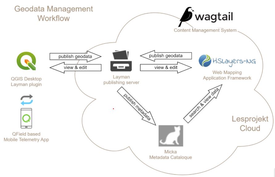
This shows the connection of powerful Open Source mapping framework HSlayers, which supports visualization of maps.
Introduction/Context
The content of the challenge will be:
- to test, how people can develop, publish and share their own maps using Web clients or desktop open source tools
- to learn how to build nice map composition
- to build own maps describing specific places or local problems
Ambition of the challenge
- Support effective reuse of existing data
- Build new data content
- Promote regions
- Prepare new type of educational content
Next steps
Part of planned activities will also be focused on the integration of new tools like IoT tools, dashboards and analytical tools.
The registration for the challenges is open! Register for this hackathon challenge HERE.