MENTOR: Karel Charvát jr.
Introduction/Context
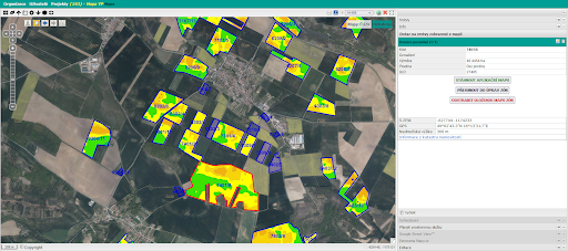
Variable rate fertilizer application (VRA) is one of the ways to reduce fertilizer consumption, increase the efficiency of fertilizer use and reduce the environmental burden. The method is based on monitoring the in-field variability of crop status or soil properties. This variability can be detected or estimated in various ways, and the result of this effort is the creation of a Management Zones map. Management Zone represents an area within the field where the same intensity of growing operation will be used. When we assign a fertilizer rate to each Management Zone within a field, we get an application map that is ready to be exported for use in agricultural machinery.
The web application that will be the subject of this challenge uses yield potential (production zones) to define Management Zones and VRA maps. The yield potential is an estimate of the long-term yield variability within the field.
Ambition of the challenge
The web application (FarmInsight) currently allows farmers to manage their field data, manually plot an application map based on underlying data such as a rough yield potential
map, or order a manually corrected Yield Potential calculation for selected fields and import them as Management Zones for the application map.
The calculation of yield potential maps is partially automated but requires some manual steps.
The goal of this challenge is to propose concepts for extending the possibilities of automatic import of management zones from other sources such as automatically calculated yield potential zones (Challange 11), or general management zones based on indicators other than yield potential.
Testing this application on data from different farms and getting feedback will be part of this challenge.
Next steps
In this challenge we will work with a web-based application for the preparation of VRA maps.
The first version of this application was created within the Horizon 2020 project databio and has been further developed since then. In the near future, the application will be operated and offered to farmers and other users under the name FarmInsight.
We will mainly use the following data:
- LPIS blocks from a continuously updated database,
- vegetation indices and other satellite data,
- calculated yield potential data.
The main objectives of this call are:
- Testing the application using data related to several farms
- Developing concepts for the use of Management Zones from other sources.
The registration for the challenges is open! Register for this hackathon challenge HERE.


