Agrihub INSPIRE Hackathon 2022: Challenge #11 Automatization of calculation of management zones based on Yield potential

MENTOR: Jana Seidlová, Heřman Šnevajs

Rapidly rising input prices are forcing farmers to save on fertilisers and use them as efficiently as possible.

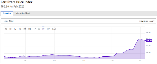
Fertilizers Price Index, 21st March 2022, source: https://ycharts.com/indicators/fertilizers_index_world_bank 

The most sensible response to rising fertiliser prices is precision agriculture based on variable approach to field. Replacing a uniform rate for the whole plot with a variable rate that takes account of the specific requirements of the site is of the greatest importance. Appiximately 8% of fertilizers are saved when the Variable Rate Application approach is used (a case study). Most of the machinary used by farmers is capable of applying variable rate of fertilizers automatically based on a prescription-application map.

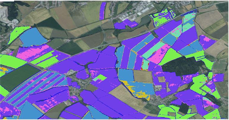
Unsupervised classification of the farm fields automatically detects field borders

The first prerequisite for calculating management zones is true field boundaries. Incorrect field boundaries lead to unusable outputs. Although there is a freely available LPIS in the Czech Republic, some of the boundaries do not correspond to reality, and so multiple crops are grown on one plot. Crop detection allows the identification of plots where multiple crops are grown and their


An example of an application map, source: Variable Rate Application of Herbicides for Weed Management in Pre-and Postemergence

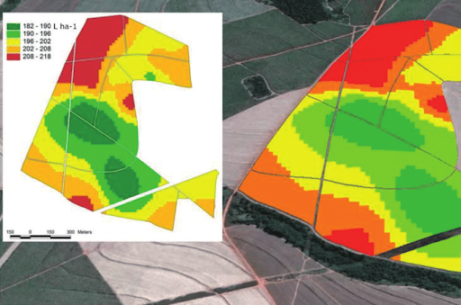
Application maps can be created based on vegetation indices derived from satellite imagery. Yield potential is a layer of relative index values on a plot over the last eight years. This provides resilience against single-year extremes.


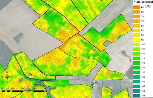
Relative yield potential, source: QUO VADIS PRECISION FARMING

The missing link in the chain is the rapid process of creating management zones from the yield potential layer. The farmer then simply assigns a fertiliser rate to each zone and an application map is created. 


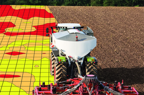
Variable Rate Aplication based on application map, source: https://www.farmmanagement.pro/the-return-of-variable-rate/ 

We work with several farms, which allows us to compare research results with the real situation and apply them in practice. 

The goal of this challenge is to automate the process of creating management zones from the yield potential layer, which would make variable fertilizer application significantly more affordable due to its accuracy and speed of creation.

The registration for the challenges is open! Register for this hackathon challenge HERE.


Agrihub INSPIRE Hackathon 2022 starts with the Challenge #10 Integrating QField with the Innovation Hub

MENTOR: František Zadražil

Geodata processing workflow tools have been developed in the last few years that offer anyone a chance to publish and share data with coworkers or a large community. All those tools are based on open source technologies and are designed to allow working with the data on desktop and web platforms. Components included in the workflow are:

A mobile application has been introduced to the workflow recently in the form of QField (https://qfield.org) and its derivatives. QField is based on the same libraries as QGIS Desktop is and targets at the in field work and collecting of data.

It is possible to publish single layers or whole map projects (compositions) to Layman. This challenge deals with the latter. All the mentioned components use an unified map composition schema to describe the map completely (https://github.com/hslayers/map-compositions). QField (and QGIS), on the other hand, uses its proprietary format for map projects and there are two ways to synchronize map projects from QGIS to QField. Copy the project directly from computer to the mobile phone or through the QField Cloud.

Main goal of the challenge is to add an option to publish existing Layman map compositions to the QField Cloud and make them available for the QField app.

The initial idea of the challenge is to

  • integrate QField to the geodata publication workflow on the level of map projects
  • transform map composition as Layman uses it to the QField Cloud project
  • store map projects in QField Cloud with the use of its API
  • Notes & remarks
    • Could some existing parts of the QGIS Layman plugin be used to do the transformation?
    • Add option to publish map composition to the Cloud instead of just Layman
    • The biggest challenge will be to unify the authentication and authorization of the current workflow (with Wagtail CMS at its core) with the authentication used by QField Cloud.

Ambition of the challenge

Integrate QField to the geodata publication workflow on the level of map projects so users can easily publish maps from existing tools to the QField Cloud and have them available in QField based  mobile apps.

Next steps

  • Host QField Cloud at our server
    • That would require solitaire QField based app (like already existing VRA Helper) to be able to connect to our own instance of Cloud
  • Authentication process will most likely require more effort than just this hackathon.

The registration for the challenges is open! Register for this hackathon challenge HERE.

OLU4Africa nominated for the WSIS Prizes 2022

It’s our pleasure to inform you that Open Land Use for Africa (OLU4Africa) map composition developed within the several INSPIRE Hackathons has been nominated for the World Summit on the Information Society Prizes 2022!

The development of the OLU4Africa dataset started during the Nairobi INSPIRE Hackathon in 2019 by exploring open data sources that could be used to build OLU4Africa. Efforts continued immediately the following year with another African INSPIRE Hackathon, the Kampala INSPIRE Hackathon 2020. That’s when the first land use map of the East Africa region was created. Since then, the dataset has undergone further development in the Open Spring INSPIRE Hackathon and its development will continue even this year during the upcoming – AgriHub INSPIRE Hackathon 2022. The team behind the development of OLU4Africa consists of participants from Uganda, Kenya, Nigeria, Ethiopia, Zambia, Egypt and Tanzania.

The main objective of OLU4Africa is to build an open seamless harmonized vector multipurpose and multilayer land use and land cover map of Africa from available open data sources. OLU4Africa is based on the simultaneously developed OLU data model version 2. Land cover and land use themes are important for many human activities and actions, while their availability and up-to-date validity is a very important aspect. OLU4Africa is being populated by datasets from African regions such as the Africover project and CCI Land Cover 2016 and newer, which has done the land cover mapping of particular African countries. Then, it was possible to use other tags from the OpenStreetMap to identify land use except for the ‘landuse’ tag. For example, ‘natural’, ‘amenity’, ‘leisure’ tags, and so on. ESA CCI LAND COVER (http://2016africalandcover20m.esrin.esa.int/) map and classification of images from Earth observation satellite data are being incorporated into the process of creating the OLU4Africa as well. The data about land cover is derived from Sentinel 2 imagery for the year 2016 and has 20 m spatial resolution. The big advantage of using this dataset is that it covers the whole continent and is relatively new. The disadvantages are related to the nature of the datasets (impossible to provide 100% precision ). 

OLU4Africa will be enriched with other available thematic datasets in the next development; especially focused on current LULC on medium and large scale maps. Availability and accessibility of this product can help for example detect changes in ecosystems at the area of interest from LULC and climatic perspective as well. 

OLU4Africa is being incorporated into the SmartAfriHub (www.smartafrihub.com), a Digital Innovation Hub for Africa. 

OLU4Africa was selected to the 360 nominated projects from a total of 1000 proposals to the WSIS Prizes 2022 contest. Next goal of being part of the selected 90 applications can be supported by YOU –  by YOUR VOTE. OLU4Africa is nominated in the Category 13 “AL C7. E-agriculture”. 

Please, support our colleagues by YOUR VOTE by the end of March! 

How to vote for OLU4Africa?

  1. Registration – please register under the following link, you will receive a verification email with a link
    https://www.itu.int/net4/wsis/stocktaking/Account/Register?ReturnUrl=%2Fnet4%2Fwsis%2Fstocktaking%2FPrizes%2F2022%2FVote
  2. Log in 
  3. In the menu, click on Prizes and then on the Vote button (or directly on the link below)
    https://www.itu.int/net4/wsis/stocktaking/Prizes/2022
  4. Select a category: AL C7.E-agriculture and you can vote

EO data for monitoring agricultural activities at 122 OGC Member Meeting

We would like to cordially invite you to join the upcoming Agriculture DWG session focused on theEO data for monitoring agricultural activities.

During the session we plan to provide insights to existing solutions, existing methods used for agriculture data analysis, but also current problems and visions for the future.

Our speakers will address following questions:

  • What kind of data do you use for monitoring agricultural activities? (satellite data, in-situ data, aerial data)
  • What data models do you use for EO data?
  • What architecture do you use for EO data?

The session will be held during the 122th OGC Member Meeting on Tuesday 1st March, 2:30 PM CET.

Agenda

  • Intro Ag DWG chair (Karel Charvát)
  • Use of Sentinel-1 and Sentinel-2 data in agricultural data analysis (Herman Snevajs, Plan4all)
  • NIVA support to the EO monitoring of CAP payments (Dominique Laurent, IGN)
  • EuroCrops and HCAT: Collecting and Harmonising open agricultural data within the European Union (Maja Schneider, TUM) 
  • E³ SAFER F³: Nature produces Ecology Economy Energy Sustainable Agriculture Forestry Environment Risk-management with Farm Fork Fun (Walter H. Mayer, PROGIS)
  • The role of standards in strengthening agricultural monitoring in Africa (Lilian Ndungu, RCMRD)
  • What are we doing wrong? Why have farmers not used EO services regularly so far? What can we change in the future? (Runar Stein Bergheim, Avinet)

Register for the workshop at https://na.eventscloud.com/website/34558/

IST-Africa 2022 – Call for Papers – Extended Deadline 31 December

Hosted by the Government of South Africa through the Department of Science and Innovation and Supported by the European Commission (EC) and African Union Commission (AUC), IST-Africa 2022 (May) is the seventeenth in an annual series of Ministerial Level Technology Research and Innovation Conferences. IST-Africa 2022 has Technical Co-Sponsorship by IEEE Society on Social Implications of Technology and IEEE Africa Council.  

The IST-Africa Conference Series provides a world-class strategic platform rotating around Africa to strengthen technology-enabled Innovation, Science and Technology and Entrepreneurship related policy dialogues within Africa and between Africa, Europe and the rest of the world, Global Development, Research and Innovation Cooperation and Community Building. It also provides an opportunity to identify potential partners for future research cooperation under Horizon Europe and other international funding programs. IST-Africa is a unique community that brings together cross-disciplinary stakeholders from public, private, education and research, societal, funding and international donor sectors with end user communities focused on ICT and STI Research and Innovation and Technology-enabled Entrepreneurship.

IST-Africa 2022 Call for Papers invites full papers (8 pages in length) using the paper guidelines and IST-Africa template provided at http://www.ist-africa.org/Conference2022/default.asp?page=paperguidelines  to be submitted online for blind peer review by the extended deadline of 31 December. 


Thematic areas addressing achieving the UN Sustainable Development Goals (SDGs) include: 

  • Technology-enabled Healthcare (mHealth /eHealth) 
  • Technology-enhanced Learning and eSkills 
  • Technology-enabled Agriculture (mAgriculture /eAgriculture) & Environmental Sustainability 
  • Energy – ICT for Power Delivery, Micro-grids 
  • eInfrastructures and NRENs (National Research and Education Networks) 
  • Next Generation Computing including Artificial Intelligence, Big Data, Cloud Computing, Future Internet, Internet of Things (IoT) 
  • eGovernment and Public Service Delivery 
  • Content Technologies including Languages; Digital Preservation 
  • Cyber Security, Privacy and Trust 
  • Collaborative Open Innovation and Technology-enabled Entrepreneurship (including Social Entrepreneurship) 
  • Global Development (including ICT4D) 
  • Societal Implications of Technology

Please download the Call for Papers for more information – http://www.ist-africa.org/conference2022/files/ISTAfrica2022_CallforPapers.pdf  and receive regular updates by following us on Twitter http://twitter.com/ISTAfricaNews    

Please note only full papers are assigned for review. 

Papers must present analysis of policy, initial or final research results or a case study. It is important to highlight actual or expected impact as well as the level of innovation. General project descriptions or descriptions of proposed research will not be reviewed. 

It is necessary for the paper submitted to include a unique element that has not previously been published and any previous published materials to be clearly referenced (including material previously published by the authors). 

Each presenter can present ONE paper in the Programme. It is necessary for papers to be presented by an author / co-author and answer questions based on the presentation during the event to ensure inclusion in the Proceedings. 

Please only submit papers for review where there are authors/co-authors who will complete registration. Please do not submit multiple papers for which there is only one author who can register. Click here for more details. 

The Agrihub INSPIRE Hackathon 2021 has its winners!

The Agrihub INSPIRE hackathon  focused on developments and innovations in agriculture, the environment, geospatial applications, remote sensing and GNSS is after two-month hacking over! More than 30 participants have contributed to all 8 challenges to support digital innovation hubs in Czechia and Slovakia. Results were evaluated by an international experts jury. The jury members Emilija Oreščanin (BioSense Institute), Bente Lilja Bye (BLB, Plan4all), Josef Hnojil (Geobusiness) and Jiri Panek (GISportal) announced the following winners for the Agrihub INSPIRE hackathon:

  • 1st place: Agro Environmental Services (presentation is available here)
  • 2nd place: Analysis, processing and standardisation of data from agriculture machinery for easier utilization by farmers
  • 3rd place: Business cases for WhiteBoard

In addition to jury, we also gave the public the opportunity to choose top 3 teams. The public vote turned out as follows:

  • 1st place: Business cases for WhiteBoard
  • 2nd place: Agro Environmental Services / Crop Detection
  • 3rd place: Extreme Weather

Congratulations to all the winning teams and many thanks for excellent work to all participants! See you in next INSPIRE Hackathon!

The Agrihub CZ&SK project  is financed by the SmartAgriHubs Project.

Agrihub INSPIRE Hackathon Final Event: Awards & Ceremony

The Agrihub INSPIRE Hackathon 2021 focused on developments and innovations in agriculture, geospatial applications, remote sensing and GNSS goes after two-month hacking into the final stage scheduled on Wednesday 15th December 1:00 PM CET! More than 30 participants have contributed to all 8 relevant series of challenges  to support digital innovation hubs in Czechia and Slovakia and their results are evaluated by an international experts jury.

During the final event, you will find out which top 3 teams were chosen by the jury and you will get acquainted with results of each challenge.

GET AN OVERVIEW OF THE HACKATHON RESULTS:

  • Results from 8 different challenges
  • Rewards ceremony and celebration


Are you interested in results of the Agrihub INSPIRE Hackathon? Do not hesitate to register for this final presentation of results & awards ceremony!

Register now!

The Agrihub CZ&SK project  is financed by the SmartAgriHubs Project.

Semantic Interoperability as an Instrument to build Digital Twins supporting SDGs at 121th OGC Member Meeting

9 December, 7:00 – 8:30 PM CET  

We would like to cordially invite you to join the upcoming Agriculture DWG session on identifying theSemantic Interoperability as an instrument to build Digital Twins supporting SDGs.

During the session we plan to provide insights into semantic data models related to different scales of agriculture related data,  semantic models for IoT and EO monitoring, semantic model for metadata and how this models can be interlinked and connected with analytical tools like AI, data mining, etc.

The session will be held during the 121th OGC Member Meeting on Thursday 9 December, 7:00 – 8:30 PM CET.

Our speakers will address following questions:

  • Why is semantics important for Agriculture?
  • Where do you use semantics in Agriculture?
  • Which semantic models for agriculture are you generally familiar with?
  • How to link different semantic models with analysis and modeling (data mining, AI, etc).

Agenda

  • Intro Ag DWG chair (Karel Charvát)
  • Publication of linked data from soil-related data sources (Raul Palma, PSNC)
  • AI & ML models for Agricultural Monitoring based on EO data (Benson Kipkemboi Kenduiywo, RCMRD)
  • Development and implementation of a Spatio-temporal Agricultural Landscape Information Model (Marija Knezevic, Technical University of Munich)
  • Semantics for Agricultural Climate Data (Heiner Denzer, METOS)
  • Panel discussion
  • Wrap-up and what’s next?

Register for the workshop at https://na.eventscloud.com/ereg/newreg.php?eventid=640986&language=eng

Plan4all as a Participating Organisation in the GEO Programme Board

We are delighted to let you know that the Plan4all association, one of  the 138 Participating Organizations of the Group on Earth Observation (GEO), has received a seat in the GEO Programme Board

The GEO Programme Board supports the ongoing development and implementation  of the GEO Strategic Plan 2016 – 2025: Implementing GEOSS through multi-year GEO Work  Programmes. 

Specifically, the GEO Programme Board: 

  • Works to ensure the overall coherence and alignment of the GEO Work Programmes with  GEO’s Strategic Objectives and Core Functions; 
  • Works to align the scope and substance of tasks, GEO Initiatives and Flagships in the  GEO Work Programme with the resources committed by Members and Participating  Organizations; 
  • Supports and enables cross-cutting coordination and knowledge exchange, especially best  practices; and 
  • Promotes GEO Work Programmes and engagement of stakeholders in their  implementation. 

Becoming a Participating Organisation of the GEO Programme Board is considered as a significant achievement and appreciation of our work and the work of our members.

AgriHub INSPIRE Hackathon 2021 has included discussion about building the team for new Horizon Europe calls

As part of the sustainability of the innovation experiments taking place within the AgriHub CZ&SK project, we decided to include a discussion on building new teams for Horizon Europe Calls as part of the activities of each AgriHub INSPIRE Hackathon challenge. Working in teams gives an excellent opportunity to identify potential partners and technologies for future challenges. This can lead to the establishment of long-term collaborations between some partners. A common work can bring together people from different technical, business and user communities and open up new opportunities for future work, which can help you to identify who may be useful for future collaborations. We have already identified some potential calls that could be relevant for hackathon challenges.

A common interest for Challenge #1 Crop Detection, Challenge #2 Crop Status Monitoring  and Challenge #8 – Business cases for WhiteBoard has been identified in the following calls:

During our next discussion we plan to select one priority. Join us in our hackathon activities. Register yourself to challenges at https://docs.google.com/forms/d/e/1FAIpQLSeBsv2awD05L6q_4zxST9hR81ar8WxSnR7zfdf9VRfQLzITnQ/viewform