Results of the Kampala INSPIRE Hackathon 2020

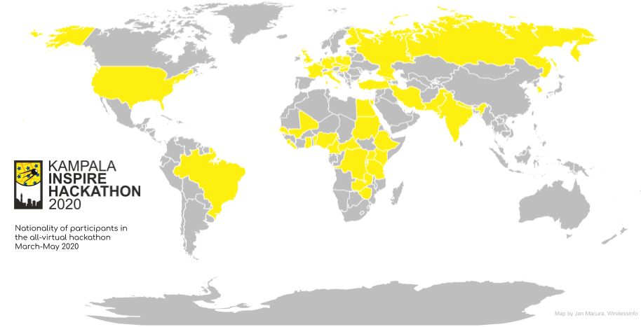
The Kampala INSPIRE hackathon that started in March concluded with online event Wednesday 6th May. Participants representing all teams joined to share their final results and to celebrate their achievements in an awards ceremony. During this 3 hours long event, we learned about the results achieved by 10 teams who have addressed the 10 challenges covering agriculture, food security, desert locust, citizen science, traffic and more. The Kampala INSPIRE hackathon gathered more than 200 registered hackers. Despite the unexpected barriers created by COVID-19, the interest of African agriculture researchers, practitioners and stakeholders at large was prominent.  

The hackers represented 42 countries world wide:  Africa 20 countries (77 % of registrants), Europe 12 countries (12 % of registrants) and 11 other countries (11 % of registrants).

Throughout the whole hackathon, all teams and mentors did an excellent job and the jury had a very difficult task to select top three teams out of the ten.  

In the end, the jury members Suchith Anand (Chief Scientist, GODAN), Lydia Mazzi Keyondo (Head of Department, University of Makerere) and Ian Jarvis (Agriculture and GEOGLAM, GEO) announced the following winners of the Kampala INSPIRE Hackathon:

  • 1st place: Challenge 4 Desert Locust / Winnie Kamau (Kenya), Maximilien Houel (France), Elias Cherenet (Ethiopia), Terefe Sodango (Ethiopia), Jecinta Wawira Muriithi (Kenya), Reagan Otukene (Uganda), Nyakato Irene (Uganda), Zakayo Kimuge (Kenya), Ambrose Kamya (Uganda) , Lenah Mwangi (Kenya), Ahmed Mahdav (Iran)i, Miderho Christus (Kenya)
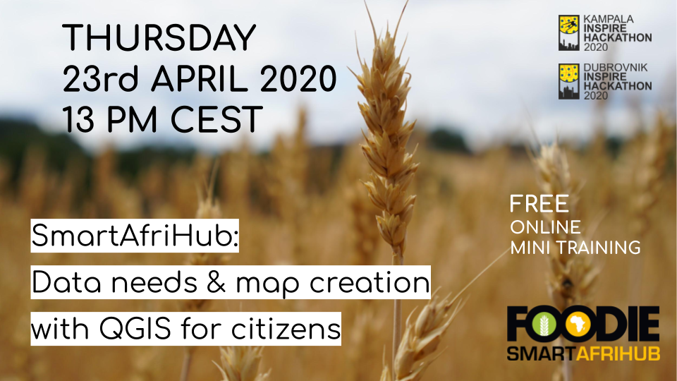
  • 2nd place: Challenge 2 SmartAfriHub / Tuula Löytty (Finland), Ssembajwe Ronald (Uganda), Simon Van Kerckhove (Belgium), Samuel Njogo (Kenya),  Antoine Kantiza (Burundi), Akaninyene Obot (Nigeria),  Felix Kimani Kariuki (Kenya), Esther Wanjiku Maina (Kenya), NGUEfACK jovis Arnold (Cameroon), MEZAFACK Karol lavoine.(Cameroon), Fouagwang Yann Wilfried (Cameroon), Jesus Simal-Gandara (Spain)
  • 3rd place: Challenge 6 Climate Change Trends for Africa / Pavel Hajek (Czech Republic), Samuel Ekwacu (Uganda), Jiri Vales (Czech Republic), Karel Jedlicka (Czech Republic)

Congratulations to all the winning teams and many thanks for excellent work to all participants: hackers, mentors, and jury! 

A special thanks to the Kampala INSPIRE hackathon supporting organizations and projects!


The INSPIRE Hackathon is not an event, it’s a process!


We are looking forward to see you in the next INSPIRE hackathon!

Kampala INSPIRE Hackathon – Invitation to the Results & Awards Ceremony

The Kampala INSPIRE Hackathon is coming to an end! Join us on Wednesday 6th May at 12 PM CEST and see the final presentation of the hackathon results. The jury including Suchith Anand (GODAN), Lydia Mazzi Keyondo (University of Makerere) and Ian Jarvis (GEO) will announce the winning teams of the Kampala INSPIRE Hackathon.


For the final event please register HERE!

RDA Hackathon on maDMPs

We would like to invite you to the hackathon on machine-actionable Data Management Plans (maDMPs).

The hackathon is open for everyone. As well as software developers RDA is looking for anyone with an interest in data – no technical knowledge is necessary – you might help with ideas generation, user testing, documentation etc.

The goal is to build integrations and test the common standard for maDMPs that is an official output of the RDA DMP Common Standards WG.

Participants of the hackathon will decide which topics to work on, but the primary goals of the hackathon are:

  • Integration of DMP tools, e.g. exchanging maDMPs between DMP tools
  • Other integrations, e.g. exchange of maDMPs between other services, such as repositories, funder systems, CRIS, etc.
  • Development of maDMP examples, e.g. to be later used for testing
  • Mapping of maDMPs to funder templates, e.g. Science Europe, NSF, etc.

The hackathon will take place on 27-28 May 2020. Registration of teams and topics starts on 20 April. Open presentation of results will take place on 29 May.

Detailed information on the hackathon are here.

Sign up and contribute your ideas!

WeObserve invites you to the webinar regarding Citizen Science in a Remote Sensing Context

We would like to draw your attention to the webinar organized by the H2020 WeObserve project, one of the co-organisers of Dubrovnik INSPIRE Hackathon 2020. The webinar is aiming to present success stories where citizen science data are combined with conventional sources of Earth Observation data. Focus will be given to showcase best practices arising from the activities of H2020 Citizen Observatories (LandSenseGROWGroundTruth 2.0SCENT) and from other projects as well, while illustrating how the integration of Earth Observation and citizen science can improve environmental monitoring.

In case you don’t want to miss a livestream of this webinar, please do not forget to register at: https://www.weobserve.eu/co4eo-webinar/.

Webinar Recording: Deep Learning for Weather Forecast

Weather is one of the most significant factors influencing agricultural production and therefore, the most accurate weather forecast possible is a very valuable information that farmer can get.

One of the weather forecast challeges is learning weather patterns using a massive volume of historical observed data and building a robust weather prediction model. Adaptation of deep learning algorithms specialized for time-series prediction can be beneficial or more accurate for weather forecasting in the local environment for farmers than the publicly available global forecast model.

On Friday’s webinar hosted by Bente Lilja Bye, we had an excellent opportunity to learn more about current methods for weather forecasting from Amit Kirschenbaum (Leipzing University) and about deep learning methods use for building weather prediction model from Ondrej Kaas (Plan4all). Unfortunately, internet connection problems made it impossible to learn about Climate Trends Change from Samuel Ekwacu (Uganda National Meteorological Authority), but he is very kind to record his presentation separately and afterwards we will provide you with that.

Here is a recording of the webinar for you!

FREE Online Training on SmartAfriHub Recording: Data needs & map creation with QGIS for citizens

In case you missed yesterday’s FREE Online Training on SmartAfriHub: Data needs & map creation with QGIS for citizens covering different tools on the SmartAfriHub platform, new mapping tools using QGIS as well as a whole range of other tools, we have a recording for you!

Besides data needs in African agriculture there was also a demonstration of how SmartAfriHub can help to solve data problems through the involvement of citizens as well as discussion of future direction for SmartAfriHub and African SDI

This webinar was extremely successful and we are very grateful for contribution of all participants!

Please fill in the following questionaire to help us help you to get better data for Africa:

FREE Online Training on SmartAfriHub: Data needs & map creation with QGIS for citizens

We are very happy to offer a FREE online mini training THURSDAY 23. April 1 PM CEST, covering different tools on the SmartAfriHub platform, new mapping tools using QGIS as well as a whole range of other tools.

DURING THIS FREE WEBINAR YOU WILL ALSO LEARN:

  • Data needs in African agriculture and potential resources
  • Demonstration of how SmartAfriHub can help to solve data problems through the involvement of citizens
  • Future direction for SmartAfriHub and African SDI
  • Q&A

What: This webinar addresses how citizens can contribute to building data for a geospatial hub. The webinar will describe a technological Geospatial Information (GI) solution for the SmartAfriHub, which could be easily replicated on other infrastructures and which include visualisation, metadata management, data management, mobile access and also the connection to external desktop platforms. All solutions are 100 % based on Open Source, so this could be also the inspiration for local developers.

We will also introduce the concept of Map composition – smart maps, which can be easily shared with others.

Part of the Webinar will be also focused on data needs in African agriculture sector, available resources and how this data could be integrated.

Why: The SmartAfriHub Map solution is something that can help to solve some problems with GI data in Africa. It is a solution, which could be easy replicated and help to solve SDI problems in Africa.

Who (is the webinar for): Students, researchers, data analytics, NGO, African and European projects, anybody in Africa and beyond, who is dealing with data management and who are ready to work with us on the new concept of “Citizens Science Maps. Farm advisors, ICT companies dealing with GI information and people from the public sector.

Do not hesitate to register for this online training/webinar HERE!

Layman QGIS Plugin – Step-by-step installation

About Layman QGIS plugin

This plugin is an extension of the geographic information system QGIS. It is client application  usable like map layer provider for Layman server. Main idea is create and edit layers and create map compositions structures on local stations, that are possible upload to server.  It can also load map compositions/layers in the opposite direction as a client of WMS and WFS services. There is necessary authorize with agrihub.cz server.

Installation of layman plugin

Layman plugin use packages that are not included in default installation of QGIS. Installation of additional packages is not simple so there is application that solves the problem on click.

Installation steps:

1. download QGIS (recommended version 3.4 LTR):

64 bit: https://qgis.org/downloads/QGIS-OSGeo4W-3.4.14-1-Setup-x86_64.exe

32 bit: https://qgis.org/downloads/QGIS-OSGeo4W-3.4.15-1-Setup-x86.exe

2. Download plugin installer here: QGIS_Installer.zip

3. Run QGIS_installer.exe like administrator!
The installer detects installed version of QGIS. If you have more QGIS versions you can choose where to install plugin in combobox. There are required administrator privileges because installer works with files stored on system volume. Installer detected dependencies that are missing.

Choose version of QGIS and click on button „Install plugin“ and wait. Installer will download latest version of plugin and prepare QGIS for plugin. This step can take about 1 minute.

4. Run QGIS. Click on tab Plugins -> manage and install plugins -> Installed and check “Atlas” plugin.

Technical information

Need more information about the plugin?

For detailed information about plugin and use cases of plugin, please visit this document:

https://docs.google.com/document/d/1R02DftMcXUCBeZvxzNUA2TGVqd0gb5nwnryyTrk6yM8/edit?usp=sharing

RDA Webinar Series in Agriculture: Intelligent Plant Data

Did you miss yesterday’s interesting livestream of the RDA/IGAD webinar on “Intelligent Plant Data Linkage: A View from History, Philosophy and Social Studies of Science,” and feature Sabina Leonelli, Professor of Philosophy and History of Science at the University of Exeter and Hugh Williamson, Research Fellow at the University of Exeter? FAO provides us with an access to the video recording and slides!

Background

Making data move across sites and communities of users continues to pose enormous logistical, scientific and ethical challenges, given the variety of conceptual backgrounds, material environments and social landscapes in which data are produced, evaluated and traded. This talk builds on extensive empirical studies of data curation and re-use in various areas of plant science to consider the conditions under which data can effectively travel across settings, groups, institutions and locations – and with which implications. Understanding these conditions is particularly relevant in the context of interdisciplinary, global collaborations targeting food security, where the linking of data coming from different sources constitutes at once a tantalizing opportunity and a significant scientific, ethical, economic and political problem. By illustrating what it takes to mobilise data responsibly across settings, the session will:

  • elicit debate over the complexity of plant data governance and its various publics;
  • highlight the crucial role of data curators in ensuring modes of data re-use that are sustainable, reliable and trustworthy; and
  • reflect on the implications of this opportunity for the status and training of curators within the wider research landscape.

For downloading above slides, please visit FAO websites: http://aims.fao.org/capacity-development/webinars/rda-webinar-series-agriculture-intelligent-plant-data