Agrihub INSPIRE Hackathon 2022: Challenge #1 Further development and testing of the application for creating application maps

MENTOR: Karel Charvát jr.

Introduction/Context

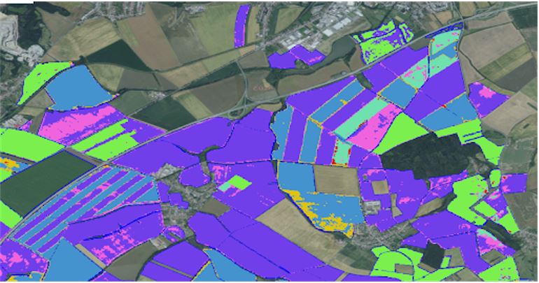
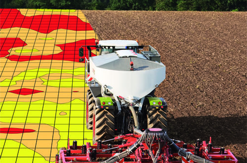
Variable rate fertilizer application (VRA) is one of the ways to reduce fertilizer consumption, increase the efficiency of fertilizer use and reduce the environmental burden. The method is based on monitoring the in-field variability of crop status or soil properties. This variability can be detected or estimated in various ways, and the result of this effort is the creation of a Management Zones map. Management Zone represents an area within the field where the same intensity of growing operation will be used. When we assign a fertilizer rate to each Management Zone within a field, we get an application map that is ready to be exported for use in agricultural machinery.

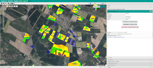
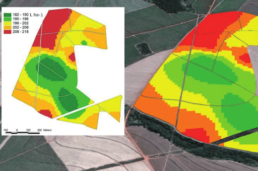
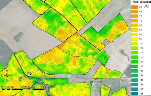
The web application that will be the subject of this challenge uses yield potential (production zones) to define Management Zones and VRA maps. The yield potential is an estimate of the long-term yield variability within the field.

Ambition of the challenge

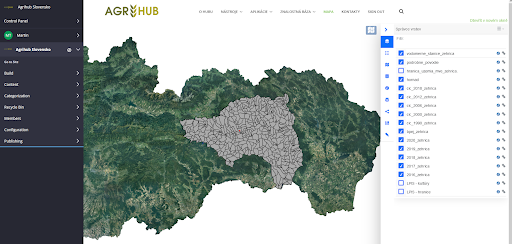
The web application (FarmInsight) currently allows farmers to manage their field data, manually plot an application map based on underlying data such as a rough yield potential 

map, or order a manually corrected Yield Potential calculation for selected fields and import them as Management Zones for the application map.

The calculation of yield potential maps is partially automated but requires some manual steps.

The goal of this challenge  is to propose concepts for extending the possibilities of automatic import of management zones from other sources such as automatically calculated yield potential zones (Challange 11), or general management zones based on indicators other than yield potential.

Testing this application on data from different farms and getting feedback will be part of this challenge.

Next steps

In this challenge we will work with a web-based application for the preparation of VRA maps.

The first version of this application was created within the Horizon 2020 project databio and has been further developed since then. In the near future, the application will be operated and offered to farmers and other users under the name FarmInsight.

We will mainly use the following data:

  • LPIS blocks from a continuously updated database,
  • vegetation indices and other satellite data,
  • calculated yield potential data.

The main objectives of this call are:

  • Testing the application using data related to several farms
  • Developing concepts for the use of Management Zones from other sources.

The registration for the challenges is open! Register for this hackathon challenge HERE.

Agrihub INSPIRE Hackathon 2022: Challenge #15 Drones utilization for Crop protection

MENTORS: Zuzana Palkova, Miroslav Konecny, Pavol Findura

Introduction/Context

The proposed methodology for identifying problematic areas of a selected crop will result from the measured data, whether in an imagery form through specialized cameras (capable of scanning in the infrared, red, blue and green wavebands), or from sensors. Consequently, the vegetation indexes (Normalized Difference Vegetation Index (NDVI), Enhanced vegetation index (EVI)) allow identifying of problematic areas in the crop and then the anticipated nature, extent and cause of damage will be determined. The system determines the coordinates, suggests procedures, methods and dosage and unmanned devices apply designated substances.

Ambition of the challenge

Possibilities for further development and implementation in agricultural practice are very wide. The ambition of the challenge is to open discussion for further cooperation in the frame of triple helix principle – R&D/farmers/SMEs.

The discussions that the INSPIRE hackathon should bring, allow to clarify some of the requirements of target consumers, primary producers, and the effect of local climate conditions.

During the preparatory activities for the challenge, several questions arose from the discussions, such as:

  • Are the NDVI and EVI methods optimal or building reference images databases of different health conditions of plants will be necessary?
  • Is there a real interest of farmers to use drones for the health and nutritional condition of crops diagnosis, considering the limitations for using drones?
  • What will be the business model for further exploitation of developed applications?

The main points for the next INSPIRE Hackathon include more precise specifications of the farmers’ needs, possibilities for plants’ image database development, and clarification of the business potential of drones utilization in agriculture practice.

The registration for the challenges is open! Register for this hackathon challenge HERE.

Agrihub INSPIRE Hackathon 2022: Challenge #14 Irrigation management

MENTOR: Jakub Fuska

The challenge is focused on the improvement of current version of system designed in first hackatho and further works. This system is calculating the water reservoir storage capacity based on the DEM of reservoir bottom and current water level with the incorporating the water reservoir watershed parameters and precipitation forecast. The input data are processed and stored in existing WebGIS server platforms (GeoServer, PostGIS).

Current system description:

  • input data: Reservoir bottom DEM, Reservoir watershed DEM, land cover of watershed; data is stored in PostGIS
  • database of water level simulations (substitution for actual sensors)
  • database of soil moisture simulations (substitution for actual sensors)
  • connection to openweathermap to provide the weather forecast data

What we expect from participants during the hackathon:

  • general insight on the created system, discussion, proposals of improvement, new functionality
  • creation of the of the hydrological modelling – new or existing models implementation and improvement in accordance to available data
  • new or improved data inputs – weather forecast, soil maps, land cover, etc.

Introduction/Context

As the farmers are pumping out the water from reservoir, the water storage is decreasing and the water level is descending. The water level elevation can be surveyed with existing prototype of ultrasonic sensor that stores the currently measured and calculated water level elevation in database and with the use of reservoir DEM we can calculate the current amount of water in reservoir.

As the longer periods of droughts are presumed worldwide (climate change in progress), the amount of available irrigation water is crucial. If we would be able to incorporate the data from watershed (watershed terrain slopes, land use, soil types, etc.) and the prediction of precipitation (weather forecast), we can predict the amount of water that will flow to reservoir during drought period and during/after rain event. This would help the farmer to manage the usage of remaining water amount in reservoir by altering the uptake of water for irrigation.

Ambition of the challenge

Challenge is aiming both on introducing the concept to the broader audience of experts both to gain the new insight to this topic and to spread the concepts idea to incorporate its principles and solutions to the further incorporating in research topics and/or in practical applications in real situations.

Next steps

  • spread the information
  • gather the information to improve the system (technical, general)
  • provide the opportunity to test the own solutions of hydrological modelling

Tools and applications:

  • system i currently working on infrastructure of virtual server of company ATAPEX (PostGIS database, Geoserver, Python server), the sensors of soil moisture are operated by company PlantControl, weather forecast is provided by openweathermap. Org API

Used data:

  • Reservoir bottom DEM, Reservoir watershed DEM, land cover of watershed; data is stored in PostGIS
  • database of water level simulations (substitution for actual sensors)
  • database of soil moisture simulations (substitution for actual sensors)
  • connection to openweathermap to provide the weather forecast data

The registration for the challenges is open! Register for this hackathon challenge HERE.

Agrihub INSPIRE Hackathon 2022: Challenge #13 Agro Environmental Services

MENTORS: Marcela Bindzarova Gergelova, Martin Tuchyňa

Introduction

Challenge will build on the experience presented and documented so far. For Agrihub INSPIRE Hackathon 2022, challenge will aim to enlarge data offerings from public sector, voluntary geographic communities as well as from private sector providers. In the area of use cases collection, challenge will prepare structure for their collection and publishing. Similarly relevant stakeholders shall be identified, documented, and where possible connected. Where real stakeholders, willing to cooperate will be identified, relevant user requirements will be identified and supported via selected use case/s.  

Ambition

For identified farmers and other related stakeholders, the challenge will prepare an initial set of available datasets via Agrihub.sk platform.

In parallel, requirements and relevant use cases will be collected. These requirements and use cases will be collected from connected stakeholders as well as by the members of the challenge team. From these collected use cases those with potential to pilot will be further developed. Among the first candidates might be those helping to:

  • Visualize farmers borders of the fields;
  • Plan farmers optimal tracks for the field operations;
  • Share information about the cultivated crops.

Challenge will also aim to identify additional information technologies and their use in order to support agricultural and environmental challenges. 

Next steps

In order to achieve above mentioned ambition following steps are foreseen:

  1. Recall of the team from the Agrihub INSPIRE Hackathon 2021 + collect new members of the team
  2. Identification of the representatives of target stakeholders
  3. Collect requirements and use cases  
  4. Identify relevant datasets 
  5. Finetune challenge/s with stakeholders’ requirements
  6. Implement possible actions to address requirements
  7. Validate outcomes with stakeholders
  8. Document the results

The registration for the challenges is open! Register for this hackathon challenge HERE.

Agrihub INSPIRE Hackathon 2022: Challenge #11 Automatization of calculation of management zones based on Yield potential

MENTOR: Jana Seidlová, Heřman Šnevajs

Rapidly rising input prices are forcing farmers to save on fertilisers and use them as efficiently as possible.

Fertilizers Price Index, 21st March 2022, source: https://ycharts.com/indicators/fertilizers_index_world_bank 

The most sensible response to rising fertiliser prices is precision agriculture based on variable approach to field. Replacing a uniform rate for the whole plot with a variable rate that takes account of the specific requirements of the site is of the greatest importance. Appiximately 8% of fertilizers are saved when the Variable Rate Application approach is used (a case study). Most of the machinary used by farmers is capable of applying variable rate of fertilizers automatically based on a prescription-application map.

Unsupervised classification of the farm fields automatically detects field borders

The first prerequisite for calculating management zones is true field boundaries. Incorrect field boundaries lead to unusable outputs. Although there is a freely available LPIS in the Czech Republic, some of the boundaries do not correspond to reality, and so multiple crops are grown on one plot. Crop detection allows the identification of plots where multiple crops are grown and their


An example of an application map, source: Variable Rate Application of Herbicides for Weed Management in Pre-and Postemergence

Application maps can be created based on vegetation indices derived from satellite imagery. Yield potential is a layer of relative index values on a plot over the last eight years. This provides resilience against single-year extremes.


Relative yield potential, source: QUO VADIS PRECISION FARMING

The missing link in the chain is the rapid process of creating management zones from the yield potential layer. The farmer then simply assigns a fertiliser rate to each zone and an application map is created. 


Variable Rate Aplication based on application map, source: https://www.farmmanagement.pro/the-return-of-variable-rate/ 

We work with several farms, which allows us to compare research results with the real situation and apply them in practice. 

The goal of this challenge is to automate the process of creating management zones from the yield potential layer, which would make variable fertilizer application significantly more affordable due to its accuracy and speed of creation.

The registration for the challenges is open! Register for this hackathon challenge HERE.


Agrihub INSPIRE Hackathon 2022 starts with the Challenge #10 Integrating QField with the Innovation Hub

MENTOR: František Zadražil

Geodata processing workflow tools have been developed in the last few years that offer anyone a chance to publish and share data with coworkers or a large community. All those tools are based on open source technologies and are designed to allow working with the data on desktop and web platforms. Components included in the workflow are:

A mobile application has been introduced to the workflow recently in the form of QField (https://qfield.org) and its derivatives. QField is based on the same libraries as QGIS Desktop is and targets at the in field work and collecting of data.

It is possible to publish single layers or whole map projects (compositions) to Layman. This challenge deals with the latter. All the mentioned components use an unified map composition schema to describe the map completely (https://github.com/hslayers/map-compositions). QField (and QGIS), on the other hand, uses its proprietary format for map projects and there are two ways to synchronize map projects from QGIS to QField. Copy the project directly from computer to the mobile phone or through the QField Cloud.

Main goal of the challenge is to add an option to publish existing Layman map compositions to the QField Cloud and make them available for the QField app.

The initial idea of the challenge is to

  • integrate QField to the geodata publication workflow on the level of map projects
  • transform map composition as Layman uses it to the QField Cloud project
  • store map projects in QField Cloud with the use of its API
  • Notes & remarks
    • Could some existing parts of the QGIS Layman plugin be used to do the transformation?
    • Add option to publish map composition to the Cloud instead of just Layman
    • The biggest challenge will be to unify the authentication and authorization of the current workflow (with Wagtail CMS at its core) with the authentication used by QField Cloud.

Ambition of the challenge

Integrate QField to the geodata publication workflow on the level of map projects so users can easily publish maps from existing tools to the QField Cloud and have them available in QField based  mobile apps.

Next steps

  • Host QField Cloud at our server
    • That would require solitaire QField based app (like already existing VRA Helper) to be able to connect to our own instance of Cloud
  • Authentication process will most likely require more effort than just this hackathon.

The registration for the challenges is open! Register for this hackathon challenge HERE.