Team 3: Sensor Data Visualisation

This is the team no. 3 for the Patras DataBio Hackathon 2019.

Team mentors: Michal Kepka, Raitis Berzins

Description: The aim of this team is to test visualisation frameworks for sensor data. Sensor data are important part of spatial data. Effective and interactive visualisation of such data in the form of charts, maps and tables brings more information to users. There are plenty of chart libraries for sensor data in different level of interactivity and development freedom. During this hackathon we would like to test a visualisation grammar – Vega, that is declarative language for creating, saving, and sharing interactive visualisation designs. With connection to SensLog we will test visualisation of sensor data produced by different types of agrometeo sensors.

TEAM 2: Agriculture Plastics in the fields of Finland

This is the team no. 2 for the Patras DataBio Hackathon 2019.

Team mentors: Jiri Kvapil, Karel Charvat, Tuula Löytty

Project description:

  1. Exploit Earth Observation data to gain accurate and up-to-date information of number of bales in the fields  The reference data is here (link).  
  1. Demonstrate  how to visualize the bale film usage on the fields in Päijät-Häme, Finland. Each bale takes about 70 m of film.The ‘standard” bale is  750mm x 1500mm rolls but there is variation. The thickness of the plastic film is  25‑30 µm. There are 4-8 layers. Film weight/bale varies from 500-1700 g. The output can be used for example to estimate the market size of bale wrapping films in a region.
  1. The third task is to map the different kinds of agriculture plastic films such as the covering films and nets for greenhouse, low or medium tunnel, soil mulching and solarisation films, irrigation and drainage pipes.

The background:

More than 80% of plastics found in marine environments has been produced, consumed and disposed of on land. In addition to inadequate end-of-life treatment of plastic waste, plastics reaches our soils through increasing use for agricultural purposes. According to APE-Europe about 750 000 tn of agriculture plastics and films is delivered to the farms annually. The image on the right performs the use in European countries annually.

The treatment of the Agriculture Plastic Waste (APW) has two main phases:  1) the plastic waste collection from the farms and 2) recycle to granules. In most European countries the collection rate is about 20-50 %. In Finland it’s 20%.  Due to the lack of coverage and functioning collecting system, the farmers dump APW to landfill, burn it at farm and cause emissions, bury it on soil or just stock the plastics on farm. The farmers want to act in a responsible manner, but the missing part is the collecting system. By continuing this manner, we waste valuable raw-material and cause damage on soil, air and seas.  The goal is to collect 100 % of the APW by 2030.

In order to reserve adequate, but not excess, facilities, machinery and man resources for collecting APW,  it’s necessary to have accurate and up-to-date information of the used agriculture plastics on the farms. The agriculture plastics distributors have some information, but there are gaps and it can lead to wrong assumptions.

Plan4all Prize for the Patras DataBio Hackathon 2019

Plan4all will sponsor a trip of up to 3 people to participate at the Pilsen INSPIRE Hackathon 2019 (23-24 September 2019) in the Czech Republic.

This special prize will be awarded by the Plan4all association at the Patras DataBio Hackathon 2019 (2-4 July 2019) to students or entrepreneurs that will be using for their hackathon projects some of the Plan4all open datasets or technologies including SensLog, WebGLayer and HSLayers NG.

TEAM 1: Management of the HSLayers Architecture

This is a short desctription of the team no 1 of the Patras DataBio Hackathon 2019 that aims to define an architecture of the software for spatial data visualisation of HSLayers – with consideration of agriculture applications.

Team members: Šimon Leitgeb, Raitis Berzins, František Zadražil, Filip Leitner, Marek Šplíchal

Project description: Discuss and agree on the culture of HSLayers development. Refactoring of HSLayers and development of specific reusable components like:

  • Loading vector layers to map
  • Conversion of SHP file to GeoJSON
  • Displaying of attribute table with the ability to edit

Plan4all Became a Member of OGC and BDVA

Plan4all became an official member of two major associations:

The first one is the Open Geospatial Consortium (OGC) – an international not for profit organization committed to making quality open standards for the global geospatial community. These standards are made through a consensus process and are freely available for anyone to use to improve sharing of the world’s geospatial data. Plan4all is an associate member of OGC.

The second is the Big Data Value Association (BDVA) – an industry-driven international not–for-profit organisation developing an innovation ecosystem enabling data and AI-driven digital transformation in Europe delivering maximum economic and societal benefits and achieving and sustaining Europe’s leadership on big data value creation and artificial intelligence. Plan4all is a full member of the BDVA.

The nature of the Plan4all association suggests that Plan4all will contribute to both organisations with capacity building, transfer of knowledge from research into practice and will help with development and adoption of international standards in the big data and geospatial domains.

Conclusions of Team 9 of the Nairobi INSPIRE Hackathon 2019

The goal of our team (Team 9: Open Transport Map Applications for Africa) was to demonstrate how interactive traffic modelling can improve traffic situation in any city. The demonstration consisted of gathering freely available / open source data and deploying a traffic modeller tool to Nairobi.

We were able to successfully develop a first stage traffic model of Nairobi and publish said model using web app. This web application is publicly accessible and functional. Using apps GUI user is able to change traffic parameters (i.e. road capacity and free flow speed) and thus to explore how will these changes influence traffic volumes in the city.

Another important takeaway from the project is that we were able to pinpoint specific bottlenecks of using only open data (e.g. capacity of road in OSM has shown to be insufficient for precise traffic modelling). Last but not least we were able to effectively communicate within our team across continents and thus discover other GIS/traffic modelling enthusiasts.

In conclusion we believe the goals of our team were met and groundwork has been laid for future traffic related projects in Africa region.

Info Day on 10 June – Patras DataBio Hackathon 2019

You are cordially invited to join the info day aimed at presenting the goals and topics of the Patras DataBio Hackathon 2019. In addition to that, experts from the DataBio project will provide some details on state-of-the-art technologies including artificial intelligence (AI), Earth observation (EO) and Internet of things (IoT) applied in the DataBio agriculture pilots.

The info day will be done using teleconference devices on Monday 10th June 2019 at 11am CEST (12pm EEST).

You can join from your computer, tablet or smartphone: https://global.gotomeeting.com/join/365229253

You can also dial in using your phone. Enter the following access code when asked: 365-229-253

Australia: +61 2 9091 7603, Austria: +43 7 2081 5337, Belgium: +32 28 93 7002, Canada: +1 (647) 497-9373, Denmark: +45 32 72 03 69, Finland: +358 923 17 0556, France: +33 187 210 241, Germany: +49 692 5736 7300, Ireland: +353 15 360 756, Italy: +39 0 230 57 81 80, Netherlands: +31 207 941 375, New Zealand: +64 9 913 2226, Norway: +47 21 93 37 37, Spain: +34 932 75 1230, Sweden: +46 853 527 818, Switzerland: +41 225 4599 60, United Kingdom: +44 20 3713 5011, United States: +1 (571) 317-3116

Nairobi INSPIRE Hackathon 2019 – Intercontinental Engagement in Open Science, Innovation and Data

The Nairobi INSPIRE Hackathon 2019 was tailored for those with a special interest in applications including Earth observation, open data, volunteer geographical information (VGI), and citizen science in and for Africa.

Assuming that the INSPIRE hackathon concept was little or at least less known to participants outside Europe, we decided to appoint mentors for a limited number of groups. The topics chosen for these (9) groups were based on the experience from both Plan4all members and co-organisers with knowledge about Africa.

The topics chosen were agriculture, climate, transport, tourism, and citizen science.

ENGAGEMENT

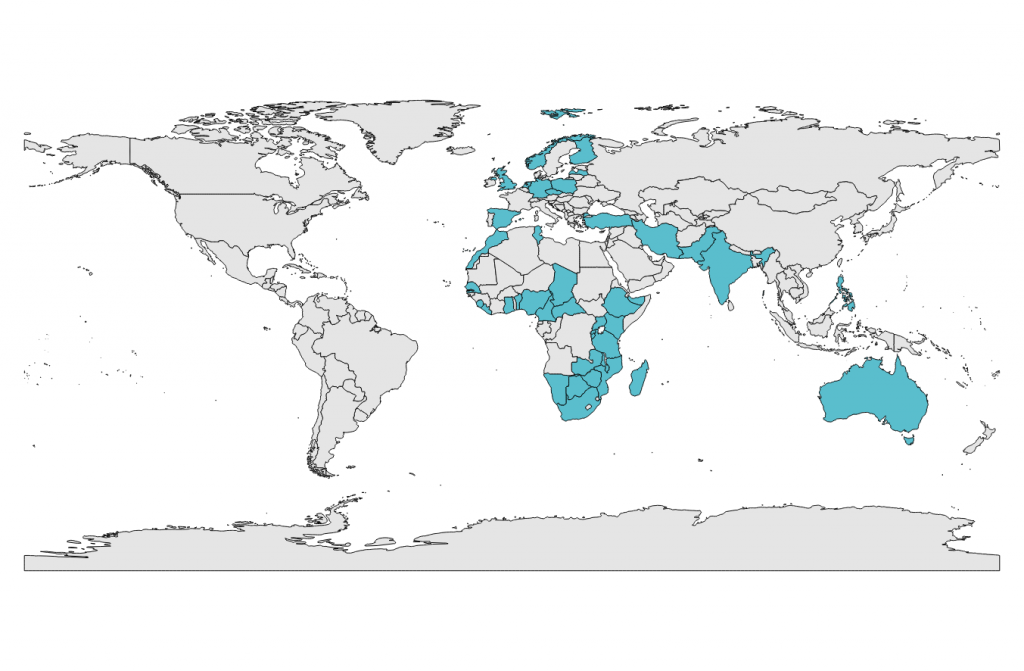
The response was overwhelming. The Nairobi INSPIRE hackathon is the biggest hackathon event to this date with overall 228 participants representing 41 countries over 4 continents. It demonstrates that there is a great interest and capability to address issues of common interest across different regions.  Out of the 41 countries there were 26 countries from Africa, 8 from Europe and 7 from other continents.

Total numbers and organisers
Participating countries

The INSPIRE hackathons take place virtually and with face to face meetings. In the case of the Nairobi INSPIRE hackathon, the mentors led the virtual part of the hackathon, and the final results were presented at the IST-Africa 2019 conference in Nairobi on 10th May in a workshop. The workshop was well visited by IST-Africa attendees that contributed to a lively discussion of the results.

Team results – presentation at the IST-Africa 2019 conference workshop

TEAM 1: Food Security in Relation to Earth Observation (GEOSS and COPERNICUS Relevance)
TEAM 2: Climatic Services for Africa
TEAM 3: Open Land Use for Africa (OLU4Africa)
TEAM 4: IoT Technologies for Africa
TEAM 5: Agriculture Innovation Hub for Africa
TEAM 6: Open Data and Data Sharing in Agri-Food Chains in Africa
TEAM 7: Smart Points of Interest – Publication of Open Data in Africa as 5-star Linked Open Data
TEAM 8: Citizen Science in Africa to Ground Truth & Exploit Earth Observation data
TEAM 9: Open Transport Map (OTM) Applications for Africa

CAPACITY BUILDING/DEVELOPMENT

The INSPIRE hackathon concept includes engagement at all levels, in particular it is providing ample opportunity for engaging education. In the Nairobi INSPIRE hackathon we organized 9 webinars covering relevant topics from all the 9 teams. The webinars typically consisted of introductions to technological topics like linked open data (SPOI), and citizen science and Earth observations. In addition, the webinars allowed discussions of concepts and ideas for the team, in addition to the various online communication channels such as Skype and Google docs. All the webinars were open to all with an interest in the topics, also for those not participating in the hackathon.

Webinar recordings available on YouTube:

TEAM 1: Food Security in Relation to Earth Observation (GEOSS and COPERNICUS Relevance)
TEAM 2: Climatic Services for Africa
TEAM 3: Open Land Use for Africa (OLU4Africa)
TEAM 4: IoT Technologies for Africa
TEAM 5: Agriculture Innovation Hub for Africa
TEAM 6: Open Data and Data Sharing in Agri-Food Chains in Africa
TEAM 7: Smart Points of Interest – Publication of Open Data in Africa as 5-star Linked Open Data
TEAM 8: Citizen Science in Africa to Ground Truth & Exploit Earth Observation data
TEAM 9: Open Transport Map (OTM) Applications for Africa

Registration is Open for the Patras DataBio Hackathon 2019 – AI for Agriculture

The registration for the Patras DataBio Hackathon 2019 is open.

Agriculture and its sustainability relies on innovative solutions using state-of-the-art technologies including artificial intelligence (AI), Earth observation (EO) and Internet of things (IoT). The DataBio project organises the Patras DataBio Hackathon 2019 in order to support innovative ideas of students and entrepreneurs addressing this challenge.

The Patras DataBio Hackathon 2019 is part of the INSPIRE Hackathon series.

The hackathon will be held at Patras, Greece on 2-4 July 2019, organized by DataBio/INTRASOFT and supported by Plan4all and several DataBio members. A preliminary info day will be held on 10th June 2019.

The participation at this hackathon is open to all free of charge, however, registration is required.