CHALLENGE #11 EO for monitoring of regional food supplies deviations

Register now!

Mentors: Jiri Kvapil, Ivo Denemark, Herman Snevajs

Covid19 pandemic and mainly subsequent restrictions was and still is a test for the food supply chain in order to provide enough food to the market to the end customers. Especially in crises a good decision can be made only with enough information. During the previous INSPIRE hackathons the yield potential maps were derived. These potential yields are highly prone to the seasonal effects such as drought, floods, optimal amount of rainfall, duration of insolation, temperature and others which can make the predictions highly different from the reality.

The challenge is to make the yield predictions more realistic by combining the predictions with the actual seasonal conditions. The more realistic the prediction is the better decision can policymakers make to prevent the danger of lack of food. Comparing yield prediction with more realistic predictions will help insurance companies to quantify the effect of the specific damage issue.

The goal of challenges is to design methods of monitoring yield and climatic conditions during the season, which can influence negatively or positively yield in the season.  As the reference layer will be used the yield production zones with the trends during the season. Temporal trends or events will be analysed on the base of three types of information

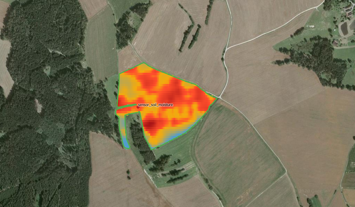
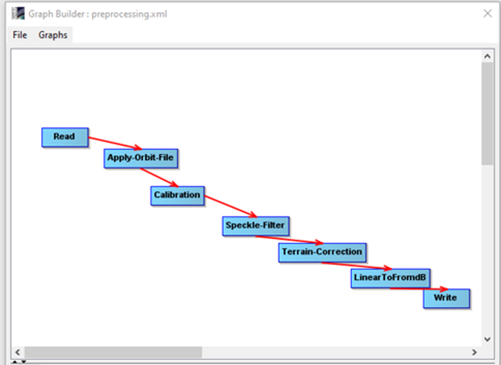
Figure 1: Deriving soil moisture from Sentinel-1 – workflow in SNAP

For the hackathon we plan to use and test results on more farms using historical satellite and climatic data from the last three years and if available we will compare these results with data from yield monitors. This data will be used for calibration. For analysis we will use statistical and visual methods already available on Lesprojekt cloud and additionally we will also use AI algorithms. The AI frameworks are available on Lesprojekt  cloud too. The main goal is to be able to predict during season problems with production and give in advance warning.

Yield production zones are areas with the same yield level within the fields. Yield is the integrator of landscape and climatic variability and provides useful information for identifying management zones [1]. This presents a basic delineation of management zones for site specific crop management, which is usually based on yield maps over the past few years. Similar to the evaluation of yield variation from multiple yield data described by Blackmore et al. [2], the aim is to identify high yielding (above the mean) and low yielding areas related as the percentage to the mean value of the field. Also, yield data’s inter-year spatial variance is important for agronomists to distinguish between areas with stable or unstable yields. The presence of complete series of yield maps for all fields is rare, thus remote sensed data are analysed to determine in field variability of crops thru vegetation indices.

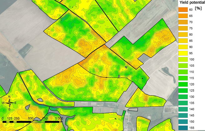
Figure 2: Map of yield potential delineated from multi-temporal Landsat imagery

[1] K. Charvát, T. Řezník, V. Lukas, K. Charvát, Š. Horáková, M. Kepka, M. Šplíchal QUO VADIS PRECISION FARMING, 13th International Conference on Precision Agriculture, July 31 – August 4, 2016, St. Louis, Missouri, USA

[2] Blackmore, B. & Godwin, Richard & Fountas, Spyros. (2003). The Analysis of Spatial and Temporal Trends in Yield Map Data over Six Years. Biosystems Engineering. 84. 455-466. 10.1016/S1537-5110(03)00038-2.

Register now!

About your mentors

JIRI KVAPIL graduated at Charles University in Prague, Faculty of Science, graduated in Cartography, Geoinformatics and Remote Sensing. His working history is GIS analyst,IT administrator, IT Architect, Head of department, Project manager. Jiri has great experience with implementation and reporting of EU Directives (INSPIRE, WFD, UWWTD, DWD), responsible for the CLC 2012 project in the CZ as project manager. He is also involved in many national projects (Ministry of Interior, Ministry of Environment, Technology Agency) and international research projects (ETC/ICM, smeSpire, SUDPLAN, FATIMA, Polirural, SIEUSOIL and others).

IVO DENEMARK works as ESA BIC Prague Business Development Manager at CzechInvest Agency. His job is to help innovative start-ups with defining and developing feasible businesses on Earth and beyond.


HERMAN SNEVAJS graduated with a bachelor degree from Palacky University in Geoinformatics, Cartography and Remote Sensing in 2019. He specializes in Earth Observation – water retention, drought monitoring and use of machine learning.


The partner of this challenge is

CHALLENGE #10 Sustainable solution to chronic diseases like diabetes through organic farming

Register now!

Mentor: Mohammed Nayeem

Around 15.5% of the adult population of Qatar is suffering from diabetes. 55 million people have diabetes in the MENA region and it is estimated that by 2045 this will rise to 108 million. Medicines are effective but not without their side-effects. What the region needs right now are more natural and organic solutions that boost the immunity of the human body and at the same time protect against chronic diseases like diabetes,
cancer etc

What we are looking for are farming techniques feasible to arid regions that will

  • Increase the green cover of Qatar and maintain sustainability
  • Grow organically without artificial enhancers
  • Contribute to the fight against diabetes with organic supplements

A winning solution would cater to all the criteria – build a sustainable model of farming on one hand, combat diabetes through superfoods on the other hand.

Register now!

CHALLENGE #9 Production and Agri Logistics chain Cyber Assurance solutions

Register now!

Mentor: Clodagh Durkan

“Agriculture companies looking to help promote food security and position themselves to be winners in the post-COVID-19 world must conserve their financial strength so that they can make the necessary strategic acquisitions, boost their efforts to build or buy technologies that promote sustainability while supporting farmer P&Ls, and develop more tailored offerings that put the individual grower in the centre.” Boston Consulting Group May 2020

The Agri sector has a large compliance requirement, that often flies below the radar, as more of the logistics and supply embraces smart connected solutions, online procurement and Ecommerce differentiated solutions. 

July 15 2020, a new regulation. temporarily called Shrems 11, invalidated the previous existing privacy shield for EU to US data transfer security. This impacts data traversing borders, credit card payments, data privacy for data at rest in transit. Many Agri businesses are unaware of their obligations under data privacy, GDPR and the enhanced EU Cyberact. This program seeks solutions to assist that process. 

KEY THEMES (ONLY INDICATIVE) 

Secure Data as Optimised Business Intelligence 

In field solutions can be centrally correlated for optimised Agri business intelligence. Security throughout the whole supply chain is a vital key for which solutions are invited e.g. consider if someone can alter the best before date on food, it has the potential to severely impact the brand value, undermine consumer confidence and lose market trust. 

All companies, particularly those in food, shops, manufacturing, farm works rushed to create processes and procures that were not pre-existing before the Covid 19 crisis and there will be a large body of work to ensure that data privacy and data security governance created over the last 20 years is not completely invalidated, putting customers at risk .. e.g. for movement tracking, health data kept private 

Smart innovation for Covid aware Agri Industry 4.0 

– Cloud integration in Traditional ICS environment supporting digital transformation. – Innovative Secure Propositions that promote Agri P&L and sustainability. – Optimised tracing solution using RFID. Bluetooth, Embedded ESIM etc 

Smart Tracking 

– Solutions for Securing remote supervision of Production equipment and failure alarming – Blockchain solution integration for tracking assurance. – Secure Animal & Herd tracking – Security assurance of perimeter systems such as ICS interfaces, Ecommerce Sites, Logistics 

tracking such as warehousing and order fulfilment. – Secure Solutions for remote supervision of farm workers and production sites – Secure Contactless staff logging solutions 

Smart Logging 

– IOT and IOT Solutions and monitors for remote sensors. – Secure Camera propositions – Security Assurance of Digital Printing – Contactless staff logging solutions 

Smart Data correlation, inspection and regulatory 

– Legal and regulatory solutions for the changing face of Food supply chain cyber innovation. – Third party Agri logistics chain access solutions. – User-friendly ecommerce solutions to EU Cybersecurity Act, PCI, GDPR, NIST, IS27001. – Data governance requirements for EU & US exports under GDPR and Schrems ii. – Machine Learning for Cyber Agri solutions 

Smart Secure Communications 

– Communication encryption. Assuring data transfer integrity. – Vendor communications – Website and perimeter security assurance and threat intelligence. 

Smart marketplace access 

– Smart Access to Cyber professional marketplace at cost effective prices. – Digital invoicing and Ecommerce solutions. – Access to new PPE procurement solutions 

Register now!

About your mentor

CLODAGH DURKAN Originally from a west of Ireland farming village, Corballa, Co. Sligo, Clodagh has 24 years of building Cyber Capability and security transformation including 4  Vodafone Operators in EU & Africa, working in Ireland, Ghana, Italy and Germany and Müllergroup, the European dairy and food logistics company.


Invitation to contribute to Remote Sensing for Future Food Security and Sustainable Agriculture

We would like to invite you to contribute to this Special Issue of the Remote Sensing journal, “Remote Sensing for Future Food Security and Sustainable Agriculture”. There are several reasons behind this special issue. Agriculture comprises a vital economic sector producing food, agro-industrial feedstock, and energy and providing environmental services through managing soil, water, air, and biodiversity holistically. The agri-food chain involves multiple actors and stakeholders that produce and provide food and agricultural commodities to consumers. In addition to farmers, there are farm suppliers, processors, transporters and market intermediaries. These actors make the agri-food chain efficient. Current agriculture is under pressure to produce high quality products with fewer inputs and in smaller areas.

In order to provide solutions to all complex problems related to the agri-food chain, we need to better understand all processes and build an interoperable knowledge management system for each agriculture sector. A key part of such knowledge management systems is data, including remote sensing data. The intention of this Special Issue is to collect ideas on how remote sensing and data derived from remote sensing can help future knowledge management for global food security and better sustainability of agriculture production in varying climatic conditions and how remote sensing can support the UN Sustainable Development Goals and the European Green Deal.

There are new systems for Earth monitoring, a number of delivery platforms have been developed, and new technologies such as artificial intelligence are now starting to be used. Remote sensing can bring data and knowledge from the global scale to provide global monitoring, monitor production on a country or regional level, but also monitor field variability. In order to optimally use remote sensing for agriculture, capacity building and training people will become a key part of the entire process.

As the Special Issue looks for innovative methods of applying remote sensing in agriculture at all scales, many different aspects have to be addressed. We hope you find the topic of this Special Issue interesting, and we look forward to your research contributions.

Please, visit https://www.mdpi.com/journal/remotesensing/special_issues/FutureFood and read more about how to submit your paper to this special issue!

CHALLENGE #8 Digitalization of indigenous knowledge in African agriculture for fostering food security

Register now!

Mentors: Antoine Kantiza, Tuula Löytty

The traditional knowledge of African agriculture has been used efficiently during many decades and until today somewhat in several areas of Africa for feeding African population. 

The indigenous knowledge in African agriculture is known to be resilient to many hazards nevertheless the traditional knowledge in agriculture is shrinking as well as the indigenous languages which were the transmission based of any indigenous knowledge in Africa as well as in the rest of the world. 

Why the traditional knowledge of African agriculture is disappearing? 

The smallholder farmers using traditional knowledge in entertaining their farms are mostly retired and their traditional know how aren’t written in scholar books for being transmitted to the future generation who expect to increase the farm production by using inputs brought abroad with high currencies like fertilizers, seeds and medicines as highlighted in the studies driven from modern schools where indigenous languages are no longer taught particularly in professional high schools. 

At the same moment, scarce seeds used in the former times are also disappearing for letting more spaces to industrial plantations or new imported seeds even if researchers begin to acknowledge that some indigenous scarce seeds tested lastly hold high calorific and nutritious quality. 

What should be done to safeguard the traditional knowledge of African agriculture? 

First of all, it is mandatory to collect and digitalize all available traditional knowledge in African agriculture before being safeguarded in safe database available for African farmers. 

Secondly, it is useful to assess the performance of traditional knowledge in African agriculture including the soil and seeds preparation; the mixture of varied crops in the same field; harvesting joined to fertilizing soil by ranking unused limbs and stems; saving crops in organic storage against harmful insects or other epidemic diseases. 

Thirdly, it is gainful to spread broadly the best practices driven from traditional knowledge in African agriculture because practices of indigenous knowledge in agriculture do not need to spend a lot of infrastructures as well as financial resources. 

What are the challenges of safeguarding traditional knowledge of African agriculture? 

The available traditional knowledge of African agriculture are kept by elder persons who are reluctant to transmitted their indigenous knowledge without being rewarded even by other persons living together in the same rural community and who may understand their indigenous languages. 

Besides, there are no longer projects supporting the traditional knowledge in African agriculture as soon as traditional knowledge in African agriculture seems prior to be out-of- date and not based on structured data. Accordingly, some best practices used in livestock like traditional surgical procedures for domestic animals have not been safeguarded as the practices aren’t taught at modern schools and no project was interested in supporting indigenous knowledge. 

Also, the traditional knowledge in African agriculture are disseminated in many indigenous languages that are not used enough by the young generation prioritizing the universal languages taught at modern schools. 

How to overcome the barriers of digitalizing traditional knowledge of African agriculture? 

It is useful that each African country sets up its national project of safeguarding traditional knowledge in agriculture and livestock targeting to digitalize and to display in free access the folk knowledge driven from the elder African farmers. 

In the similar way, African indigenous languages may be safeguarded and promoted specifically at schools where books and lessons should taught the best practices of indigenous knowledge in African agriculture as well as in other fields of sustainable developments goals. 

Goals of the challenge:

The optimization of best practices driven from the traditional knowledge of African agriculture joined to modern technologies in agriculture innovation will be the support to erase hunger and to increase food security among African countries in accordance with the second sustainable development goal of Agenda 2030 targeting mainly to : ” end hunger, achieve food security and improved nutrition and promote sustainable agriculture ”. 

The digitalization of indigenous knowledge of African agriculture will serve to create a big database of African traditional knowledge in Agriculture in favor of future African farmers’ productivity as well as to work out for the best issues of the hot questions below. 

Register now!

Your mentors will be:

Antoine KANTIZA is holder of a Post-University Degree in European Studies and a Diploma of Superior Studies in Using Technologies of Information and Communication for Education and Formation, DESS UTICEF in short delivered respectively by the University Catholic of Louvain in Belgium and the University Louis Pasteur of Strasbourg in France. As an independent researcher, he h as written many publications available online and offline in varied topics including Economic, Social and Rule of law affairs; Sustainable Development Goals implementation; ICT4Agriculture community at https://www.e-agriculture.org belonging to FAO where he is designated: “Featured Member” since 2011. He has been Professor of International Policy at International Studies Centre of Bujumbura. He has been granted by the WBG, the Awards of Course Heroes in Future of Work: Preparing for granted by the WBG, the Awards of Course Heroes in Future of Work: Preparing for Disruption and in Unlocking Investment and Finance in Emerging Markets and Developing Economies. He has been nominated: “Peer-Reviewer for Net Journal of Agricultural Science”.

Tuula Löytty earned her MSc in Industrial Engineering and Management from Lappeenranta Technical University, and her Bachelor in Process Technology from the Satakunta University of Applied Sciences, Faculty of Technology, Finland. Her career can be segmented into six overlapping blocks, which nowadays enable her a wide view over business life and society. She has worked during three decades at three different lines of business: basic food production i.e. dairy- and sugar industry, metal industry and higher education. Her competences are demerged into three pillars: value chain management including logistics- and purchasing processes, continuous improvement methodologies, and project management, which covers both tangible delivery projects and research-, development- and innovation projects.
Tuula Löytty is the owner of Smart & Lean Hub Oy, Finland.

CHALLENGE #7 Blockchain Technology for Food Security in Africa

Register now!

African food supply chain is made of smallholder farmers who often do not get the due reward for their produce thereby leaving the farmers poorer. Typical example in Africa during the outbreak of the COVID-19 pandemic, the government gave out incentives to boost agricultural production but the incentives never got to the farmers in the rural areas. This can be attributed to so many things like lack of rural farmers’ records, information asymmetry and poor government policies.

This challenge approach will completely rely on the use of smart contracts to have records of all rural farmers, monitor and manage all communications and transactions within the supply chain network among all of the stakeholders. All information will be verified, recorded and stored in a centralized interplanetary file system database which will allow for a secure and cost effective supply chain system for the stakeholders. Thus, our proposed model gives a transparent, accurate, and traceable supply chain system. Blockchain technology will be used to solve the problem of agricultural food supply chain traceability, further addressing the food safety issues, and to demonstrate its link in each supply chain in the implementation process details. 

The blockchain provides an innovative resolution for achieving these goals: foremost, it provides a permanent record for every dealings section that is sorted into individual blocks and cannot be tampered with. Secondly, it will replace those ancient paper following systems and manual observance systems, thus forestalling the standard approach of the provision chain from suffering the wrong impact. 

The goal of the challenge

  1. Develop a database where all the farmers information are stored
  2. Develop a blockchain technology that will be used for mapping and traceability of food packages which is very much needed in both production and supply chain.
  3. To build a community of transparency and accountability between actors involved in the food value chain that will ensure food security in Africa in the post COVID-19 pandemic.

Register now!

Your mentors will be

Akaninyene Patrick Obot is an Academia/Researcher in the Department of Agricultural Economics and Extension, Nnamdi Azikiwe University, Awka, Anambra State, Nigeria. He is also a Project Consultant at Ukana West 2 Community Based Health Initiative (CBHI), Akwa Ibom State, Nigeria where they advocate for equitable access to quality and affordable health care services for all.


CHALLENGE #6 Atlas of the Best Practices – PoliRural Cases

Register now!

In addition to the direct health threat, COVID-19 also brings with it a large number of negative side effects, such as quarantine, restriction of movement, restriction of work, changes in supply, reduction of hobby activities and cultural activities, etc. Through the collection of best practice examples, the challenge aims to contribute to the discussion on how the negative impacts of COVID-19 can be addressed by innovative interventions, be they a new policy, a private sector scheme, a community measure, or an initiative started by an individual living in a countryside.

Conception
The Challenge will collect and publish practical examples from across Europe, with the overall goal of reducing negative spill-over effects of the epidemic on everyday life in the rural regions. The individual examples will be published on the Atlas of the Best Practices, which is a platform developed by the Enabling project (https://www.enabling-project.com/) and is implemented into the PoliRural innovation hub (https://hub.polirural.eu/best-practises) to showcase success stories of rural new entrants.

Basic Scheme of the Atlas

The individual topics will also be addressed in close correlation with the Polirural projects (https://polirural.eu/), which focuses on the analysis of rural policies.

System Components of the Atlas

Register now!

Your mentors will be

PETR HORAK Education: Mendel University of Agriculture and Forestry in Brno, Forest engineering. SW development experience, mainly web solution for geo-spatial data, GIS specialisation, research, development, testing and exploitation of services and geo-information technologies for spatial data management in the area of natural, technical and social sciences, new development, testing and exploitation of services and technologies for spatial data management in areas of rural development including agriculture and forestry, emergency systems, logistics and public administration, implementation of new communication and navigation technologies. Extensive experience of EC projects (project management, development and implementation): Enabling – Enhance New Approaches in BioBased Local Innovation Networks for Growth (2017 – present), Envirogrids (2009 – 2012), Plan4all (project manager, system developer, 2009 – 2011), EarthlookCZ (co-ordinator of the project, 2007-2009), Collaboration at Rural – C@R (2006 – 2010), AMI4FOR new model for knowledge management in forestry based on integration of principles of ambiente mobile intelligence, new methods of navigation and integration of space imaging (2005 – 2008), MILQ-QC-TOOL the development of predictive models on the Internet for optimisation of heat treatment of raw milk in small and medium-sized dairy companies (2005 – 2007), NATURNET-REDIME New Education and Decision Support Model for Active Behaviour in Sustainable Development Based on Innovative Web Services and Qualitative (2005 – 2007).

PAVEL KOGUT, MSc, is an experienced researcher and training facilitator who has worked on an extensive portfolio of agriculture related projects e.g. agINFRA, Green Learning Network, PoliRural. He is currently involved in the day-to-day management of an H2020 project PoliVisu, which aims to improve policy making through data and advanced visualisations. Prior to that, Pavel was an assistant analyst at the Hague Centre for Strategic Studies. Pavel’s career in research began in London’s third sector where he helped a number of charities evaluate their projects for the Big Lottery. 

CHALLENGE #5 WhiteBoard – Future Collaborative Maps

Register now!

Mentors: Karel Charvat, Runar Bergheim, Raitis Berzins

Our technologists have been developing web map applications for 23 years and have observed and taken part in the transition from plain HTML image maps via early instances of browser-specific plugins with custom APIs to present day HTML5/Javascript web map applications built on high performing client-side libraries and consuming standardized web map services across a decentralized and global web of resources.

Much effort has been put into the sharing of data, the publishing of maps and the decentralized capture of data through field mapping applications and applications dedicated to user generated content allowing individual users to contribute to ever-growing centralized yet shared information resources.

Web map protocols are largely RESTful with some tweaks added to support features like authentication. With the mainstream availability of technologies like Web Sockets that enable persistent connections between clients, there is a potential for real-time collaboration in map and spatial data creation.

The prerequisite for this is a format that allows the representation, storage and transfer of maps and map data. Since the Web Map Context service was conceived, little has changed in terms of standardization of interchange formats for maps.

The working title of our effort is a “Map Whiteboard” and the transport and storage for data is a JSON based format called “Map Compositions” that draws on the early work of Web Map Context documents, but that extends them with 20 years worth of added features.

With the proposed technology, we will support a number of common use cases for “maps” that have shown themselves exceptionally resilient despite the many and significant improvements that have been made to map technology.

Expected outcomes of the team members’ and mentors’ common efforts are: 

  • validate technological concept in different context
  • tested technologies with different users
  • run large experiment with different communities
  • organise collaborative session with group of users
  • Explain to user communities principles of Whiteboard
  • Extend current functionality

Register now!

About your mentors

KAREL CHARVAT graduated in theoretical cybernetics. He is a member of International Society for Precision Agriculture, Research Data Alliance, vice chair of Club of Ossiach, CAGI, and CSITA. He was in period 2005 – 2007 President of European Federation for Information Technology in Agriculture Food and Environment (EFITA). Now is chair of OGC Agriculture DWG. He was organiser on many hackathons, where as most important were series of INSPIRE Hacks and MEDHackathon. He work on implementation on national INSPIRE Geoportal. Now he is also active in Plan4all association. He has long time experience in ICT for Environment, transport, Agriculture and Precision Farming. Now he is one from promoters of Open and Big Data in Agriculture in Europe. Participation in projects: Wirelessinfo, Premathmod, EMIRES, REGEO, RuralWins, Armonia, aBard, EPRI Start, Ami@netfood, AMI4For, Voice, Naturnet Redime, Mobildat, SpravaDat, Navlog, c@r, Humboldt, WINSOC, Plan4all, Habitats, Plan4business, SmartOpenData, FOODIE, SDI4Apps, AgriXchange, FOODIE, SDI4Apps, OTN, DataBio, EO4AGRO, EUXDAT, SmartAgriHub, SKIN and other projects.

RUNAR BERGHEIM Co-founder and director of research and development in Norwegian consultancy company AVINET, Bergheim has been engaged in tourism, planning and geomatics projects for 22 years. Graduated from Sogn og Fjordane University College in 1997 in Spatial Planning, he went on to work with regional development for three years before co-founding a technology company focussed on providing web based map solutions for government sector. Bergheim has long experience from tourism projects having been a consultant to the Norwegian Trade Organization (NHO) on digital solutions for tourism in the early 2000s through to implementing transnational tourism initiatives like the North Sea Trail and North Sea Cycle Route from 2005 up until 2017. Bergheim has been active in INSPIRE, in Smart Cities with a particular emphasis on applied spatial technology. In the last few years, he has been working on big spatial data management and analytics. His combined experience spans more than 200 projects in 20+ countries. Bergheim participates in CosC on behalf of Avinet, the legal entity that will hold an equity share in the company.

RAITIS BERZINS A full stack developer with 14 years experience in designing and developing desktop and web based applications. Previously worked on topics range from web based GIS software for tourism and agriculture to hotel management, e-learning and decision support systems. Latest projects are Sdi4Apps, OpenTransportNet, Foodie and Databio, but longer term ongoing efforts have been in development of mapping library Hslayers-ng and 4Hotel property management system.

CHALLENGE #4 Rural Attractiveness Visualization

Register now!

Mentors: Otakar Cerba, Sarah Velten, Pavel Kogut

The PoliRural project has prepared the dataset describing rural attractiveness in Europe from various perspectives e.g. demography, natural capital, social capital, economy, agriculture, living conditions.

Task 1
The first task of this challenge is to find relevant methods for assessing rural attractiveness in NUTS 3 regions. Building on the existing techniques (e.g. index calculation, clustering, Multiple-Criteria Decision Analysis), the method should offer new insights and allow easier identification of similarities and differences between the regions. 

To make the results easier to understand by non-experts, the manipulated data should be visualised on a map. Which cartographic parameters and graphic variables to use is at the discretion of the team working on this challenge.

Task 2
The second task focuses on the prototype web application which currently displays rural attractiveness data dynamically for the whole of the EU. The goal is to enable custom selection of individual regions for further comparison. The resulting clusters should be presented as nodes that are grouped together according to common attributes. The figure below shows a hypothetical cluster diagram based on a custom selection of 12 regions. 

For the second objective, the team would need to work with a predefined list of regions:

  1. BE251 Vlaams Gewest NUTS 2
  2. CZ02 Strední Cechy NUTS 2
  3. IE041 Border NUTS 3 
  4. EL64 Sterea Ellada NUTS 2 
  5. ES423 Cuenca NUTS 3 
  6. ITF4 Puglia NUTS 2
  7. LV008 Vidzeme NUTS 3
  8. PL913 Warszawski zachodni NUTS 3
  9. SK Slovakia Slovensko NUTS 1
  10. FI1C2 Kanta-Häme NUTS 3
  11. FI1C3 Päijät-Häme NUTS 3
  12. MK North Macedonia NUTS 1

Task 3

The final task is all about enabling map users to explore the rural situation in different regions in more detail. This should be done by creating a pop-up window with contextual information on e.g. rural challenges, existing policies. The team can work with just one of the above regions for this task. Contextual information should be taken from the pilot fiches and D4.4 Needs-Policies Canvas.

Register now!

Your mentors will be

OTAKAR CERBA Assoc. prof. Otakar Čerba, PhD works at the Department of Geomatics (Faculty of Applied Sciences, University of West Bohemia, Plzeň, Czech Republic) and cooperates with Plan4all. He is focused on cartographic visualization of spatial data, Linked Data on the geographic domain and semantic issues of geographic data. He has been involved in many international projects such as Polivisu, Humboldt, SDI4Apps, SmartOpenData, Plan4all or ROSIE. Otakar Čerba is the member of the board of Czech Association of GeoInformation and the chair of the Commission on Maps and the Internet of International Cartographic Association

SARAH VELTEN, PhD,  works for Plan4all and currently contributes to the project Polirural. An environmental scientist by training, she obtained her PhD in social and political sciences at Leuphana University Lüneburg, Germany. Her work has focused on issues of sustainable agriculture, rural development, biodiversity conservation, governance, participation, and stakeholder collaboration, using mainly qualitative and mixed qualitative and quantitative research approaches. She has previously been involved in the ERC-funded project EDGE (Evaluating the Delivery of Environmental Governance using an Evidence-based Research Design) and the RURAGRI ERA-NET project MULTAGRI (Rural development through the governance of multifunctional agricultural land use).

PAVEL KOGUT, MSc, is an experienced researcher and training facilitator who has worked on an extensive portfolio of agriculture related projects e.g. agINFRA, Green Learning Network, PoliRural. He is currently involved in the day-to-day management of an H2020 project PoliVisu, which aims to improve policy making through data and advanced visualisations. Prior to that, Pavel was an assistant analyst at the Hague Centre for Strategic Studies. Pavel’s career in research began in London’s third sector where he helped a number of charities evaluate their projects for the Big Lottery.

CHALLENGE #3: Citizen Science Network for Peer to Peer Maps Sharing

Register now!

Mentors: Frantisek Zadrazil, Pavel Hajek, Jan Vrobel

Current situation with COVID 19 is opening new possibilities for virtual contribution of citizens to collect scientific data. Many scientific information can be collected in the form of a Map. Significant progress has been made in standardization of data access protocols and implementation of servers and clients capable of combining and visualizing remote datasets through mainstream OGC standards like WMS and WFS. This allows information to be flexibly re-used across organizational and thematic boundaries.

This allows people to build spatial applications that combine public, proprietary and private information for a multitude of purposes ranging from spatial planning, to smart agriculture and, of great relevance of late, crisis management.

Something that is still missing and that would add significant business value is a mechanism for sharing complex map compositions that combine data sharing services, cartography, visualizations and geospatial markup. Shared map compositions should be possible to explore in mainstream proprietary and open source GIS tools targeting both online and desktop environments.

  • We are sharing a lot of data
  • Data are facts and are «true» within limits
  • We share a lot of data across systems
  • Maps can be many things
  • Expressions of opinions
  • Means of discovering multi-dimensional spatio-temporal patterns
  • Communication of knowledge, science
  • Maps are not necessarily true
  • We share very few maps across systems – except as images

The idea is to publish maps in the form of Map Compositions.  Map compositions are:

  • An open JSON based interchange data model that describe maps (see https://github.com/hslayers/hslayers-ng/wiki/Composition-schema )
  • Extends the OGC Web Map Context specification that is limited to stacking WMS layers on top of eachother
  • In some ways map compositions resemble the «project files» of professional GIS tools
  • Includes a stacks of «layers»
  • Includes embedded «markup», redlining
  • Are lightweight
  • Are interchangeable
  • Are data centric rather than visualization centric
  • Can be rendered using web map clients and professional GIS clients
  • Can be used as a platform for collaborative development of maps and data

In the past, a solution was developed, which is part of the concept of more Digital Innovation Hubs. See the scheme:

This allows easy publishing of new Maps from the Web environment and also from QGIS. The focus of Hackathon will be to build a citizen community, which will be able share maps on DiHs. We will include more DiHs into experiment:

The second goal will be to develop a mechanism, which will allow to share this map compositions among different Hubs. This will lead to the peer to peer concept of Map sharing.

Additional dream is to involve external solution and test sharing of maps with other platforms

Expected outcomes of the team members’ and mentors’ common efforts are: 

  • build citizens science communities sharing maps
  • validate existing platforms
  • build large scale peer to peer network
  • use maps for agriculture support and regional development
  • promote rural regions

The challenge will demonstrate added value in terms of improved technology and skills among potential data users as well as the economic potential of reusing open data, validated through real-world trials. Participants will gain technical experience with open data, metadata, standards, online collaboration, content creation, spatial data, geomatics and thematic mapping. Furthermore,they will gain knowledge on natural and cultural heritage and receive training in how to think business and sustainable social innovation

Register now!

About your mentors

FRANTISEK ZADRAZIL is a Project Coordinator of the HSLayers-NG framework. He has been working in the GIS field since he graduated in 2006 (Computer Graphics and Virtual Reality Engineering). After the years of SW development using various platforms (MapServer, GeoServer, ArcGIS) he became a GIS team leader and project manager and contributed to implementing numerous GEO systems for the public and private sector. He has an expertise in GIS architecture and analysis.

PAVEL HAJEK is a researcher and a lecturer at the Department of Geomatics. He participated in several EU projects such as OpenTransportNet, GEPAM, Peregrinus Silva Bohemica or EUXDAT. His focus is mainly on data modelling, assembling and gathering. His doctoral internship was taken at TU Delft (2014). Research activities: Geographic Information Systems (GIS), multidimensional data modelling – especially 3D data handling, cartography and visualisation, 3D GIS/CAD/BIM.

JAN VROBEL is a developer with the main focus on python QGIS plugins. He graduated in field applied informatics. Since 2016 he has been working in the field of GIS and software development. He has experience with GIS software like QGIS, Erdas and with developing in python and javascript languages.


Register now!