Mentors: Frantisek Zadrazil, Pavel Hajek, Jan Vrobel
Current situation with COVID 19 is opening new possibilities for virtual contribution of citizens to collect scientific data. Many scientific information can be collected in the form of a Map. Significant progress has been made in standardization of data access protocols and implementation of servers and clients capable of combining and visualizing remote datasets through mainstream OGC standards like WMS and WFS. This allows information to be flexibly re-used across organizational and thematic boundaries.
This allows people to build spatial applications that combine public, proprietary and private information for a multitude of purposes ranging from spatial planning, to smart agriculture and, of great relevance of late, crisis management.
Something that is still missing and that would add significant business value is a mechanism for sharing complex map compositions that combine data sharing services, cartography, visualizations and geospatial markup. Shared map compositions should be possible to explore in mainstream proprietary and open source GIS tools targeting both online and desktop environments.
- We are sharing a lot of data
- Data are facts and are «true» within limits
- We share a lot of data across systems
- Maps can be many things
- Expressions of opinions
- Means of discovering multi-dimensional spatio-temporal patterns
- Communication of knowledge, science
- Maps are not necessarily true
- We share very few maps across systems – except as images
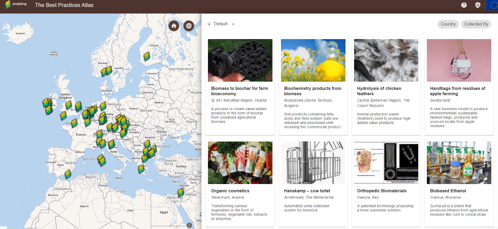
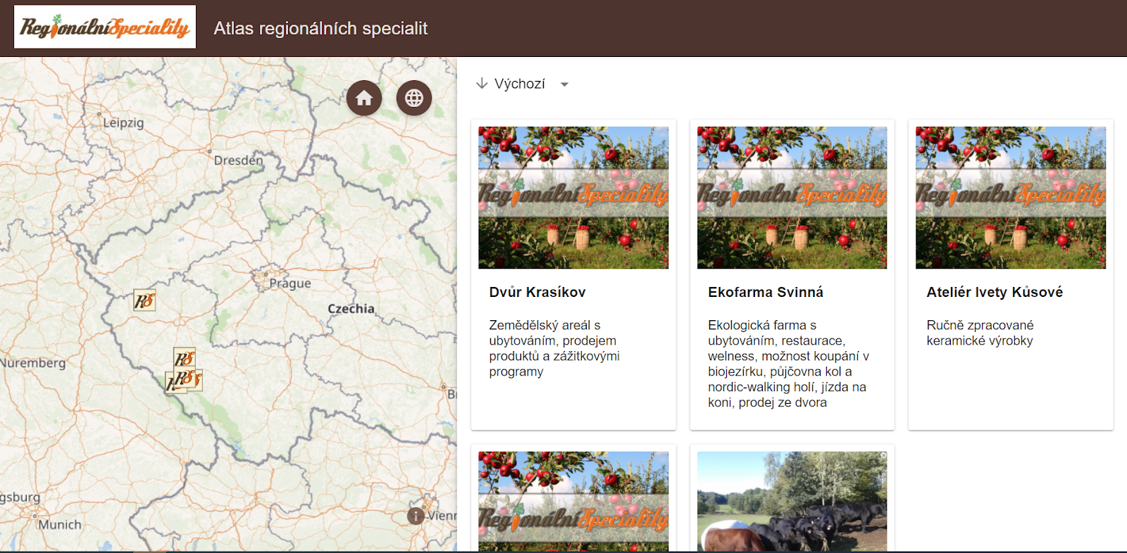
The idea is to publish maps in the form of Map Compositions. Map compositions are:
- An open JSON based interchange data model that describe maps (see https://github.com/hslayers/hslayers-ng/wiki/Composition-schema )
- Extends the OGC Web Map Context specification that is limited to stacking WMS layers on top of eachother
- In some ways map compositions resemble the «project files» of professional GIS tools
- Includes a stacks of «layers»
- Includes embedded «markup», redlining
- Are lightweight
- Are interchangeable
- Are data centric rather than visualization centric
- Can be rendered using web map clients and professional GIS clients
- Can be used as a platform for collaborative development of maps and data
In the past, a solution was developed, which is part of the concept of more Digital Innovation Hubs. See the scheme:
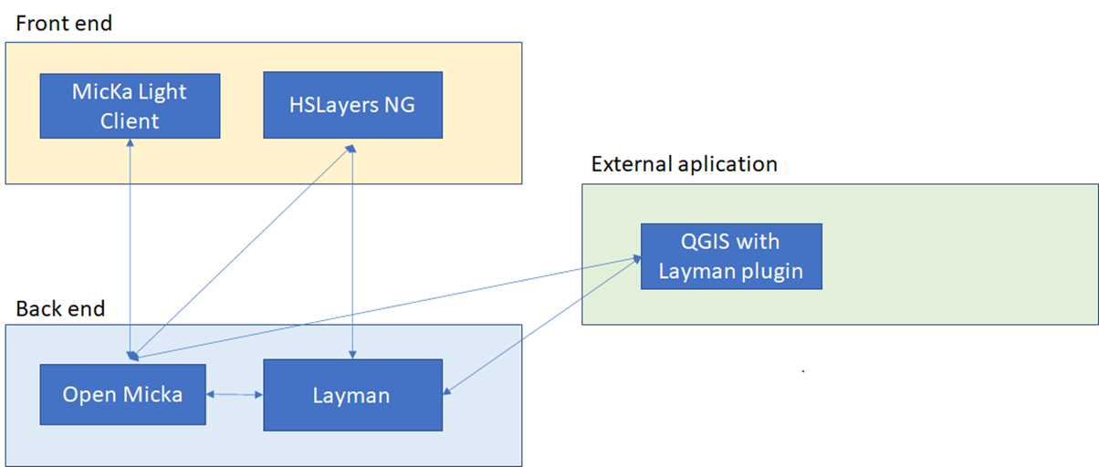
This allows easy publishing of new Maps from the Web environment and also from QGIS. The focus of Hackathon will be to build a citizen community, which will be able share maps on DiHs. We will include more DiHs into experiment:
- https://www.smartafrihub.com/cs/home
- https://www.smartafrihub.com/cs/home
- https://www.agrihub.cz/iw/home
- https://hub.sieusoil.eu/
- https://hub.plan4all.eu/home
The second goal will be to develop a mechanism, which will allow to share this map compositions among different Hubs. This will lead to the peer to peer concept of Map sharing.
Additional dream is to involve external solution and test sharing of maps with other platforms
Expected outcomes of the team members’ and mentors’ common efforts are:
- build citizens science communities sharing maps
- validate existing platforms
- build large scale peer to peer network
- use maps for agriculture support and regional development
- promote rural regions
The challenge will demonstrate added value in terms of improved technology and skills among potential data users as well as the economic potential of reusing open data, validated through real-world trials. Participants will gain technical experience with open data, metadata, standards, online collaboration, content creation, spatial data, geomatics and thematic mapping. Furthermore,they will gain knowledge on natural and cultural heritage and receive training in how to think business and sustainable social innovation
About your mentors
 FRANTISEK ZADRAZIL is a Project Coordinator of the HSLayers-NG framework. He has been working in the GIS field since he graduated in 2006 (Computer Graphics and Virtual Reality Engineering). After the years of SW development using various platforms (MapServer, GeoServer, ArcGIS) he became a GIS team leader and project manager and contributed to implementing numerous GEO systems for the public and private sector. He has an expertise in GIS architecture and analysis.
 PAVEL HAJEK is a researcher and a lecturer at the Department of Geomatics. He participated in several EU projects such as OpenTransportNet, GEPAM, Peregrinus Silva Bohemica or EUXDAT. His focus is mainly on data modelling, assembling and gathering. His doctoral internship was taken at TU Delft (2014). Research activities: Geographic Information Systems (GIS), multidimensional data modelling – especially 3D data handling, cartography and visualisation, 3D GIS/CAD/BIM.
 JAN VROBEL is a developer with the main focus on python QGIS plugins. He graduated in field applied informatics. Since 2016 he has been working in the field of GIS and software development. He has experience with GIS software like QGIS, Erdas and with developing in python and javascript languages.