Challenge 10: Interchangeable map compositions in support of collaborative spatial intelligence

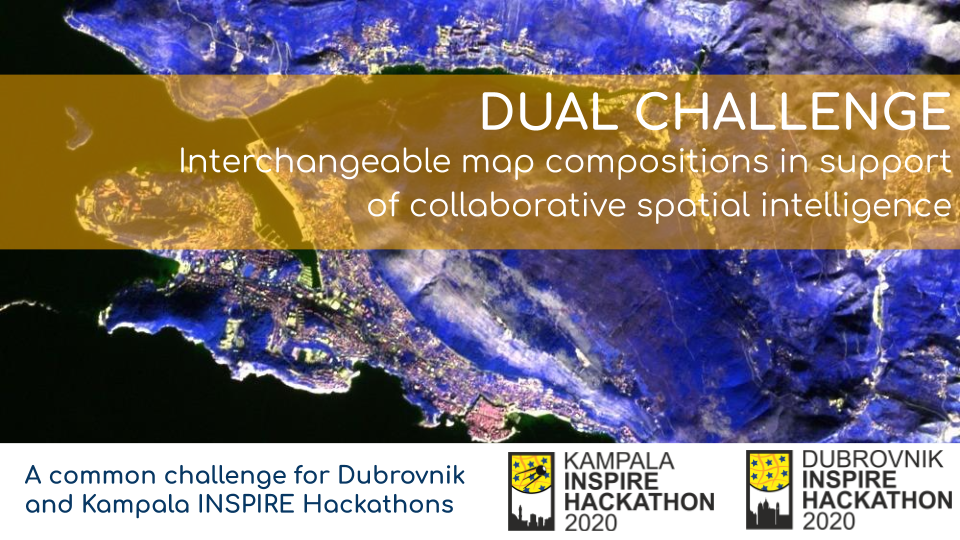
This is a description of Challenge No. 10 of the Kampala INSPIRE Hackathon 2020 led by Raitis Berzins, Runar Bergheim, Karel Charvat, Dmitrij Kozuch, Jan Vrobel and Irena Koskova. For more information about mentors see the link.

Significant progress has been made in standardization of data access protocols and implementation of servers and clients capable of combining and visualizing remote datasets through mainstream OGC standards like WMS and WFS. This allows information to be flexibly re-used across organizational and thematic boundaries.

This allows people to build spatial applications that combine public, proprietary and private information for a multitude of purposes ranging from spatial planning, to smart agriculture and, of great relevance of late, crisis management. However, as long as we only share data, this requires the users to be proficient with GIS and a wide range of technical concepts.

“Maps are where data are transformed into knowledge”, as the GIS-cliche goes, but while the phrase is worn the fact remains valid.

It would add significant value to both government, business and private tasks if we had a mechanism for sharing complex map compositions that combine data sharing services, cartography, visualizations and geospatial markup. Shared map compositions should be possible to explore and interact with in mainstream proprietary and open source GIS tools and both online and desktop environments.

The importance of this challenge is underlined by the current COVID 19 pandemic that strengthens the need for online collaboration and smart use of technology to manage crisis, supply, logistics and policies.

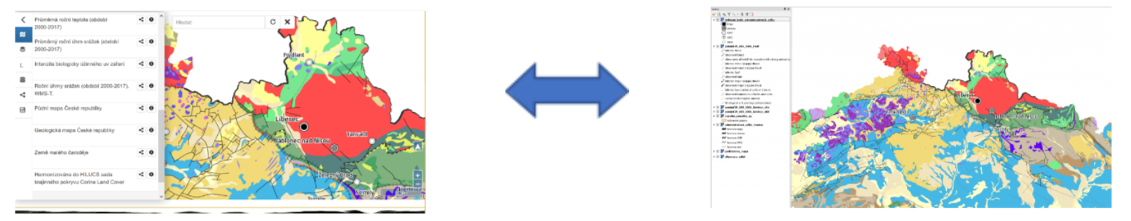
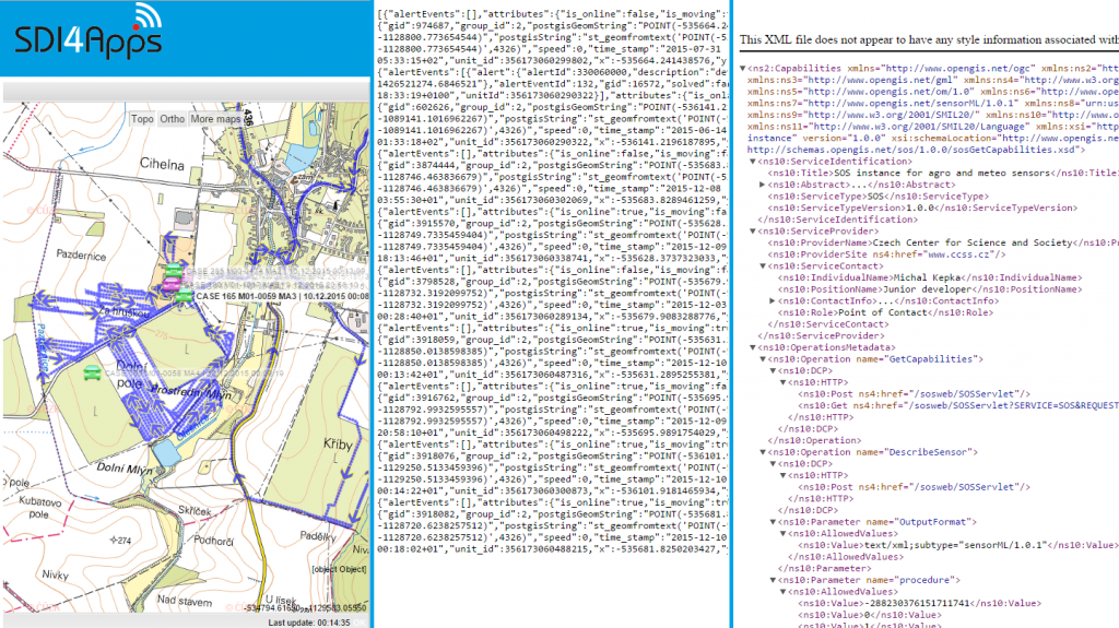
This challenge seeks to further develop a proposed standard format for interchangeable map compositions building on the results of several previous hackathons. A map composition standard opens the door to another interesting innovation, namely an application that is to maps what Google Docs is to text documents.

The challenge will work in parallel with evaluating and extending the current draft specification for JSON map compositions as well as build a working prototype of a web based collaborative map builder application. It will be also be possible to share the map compositions with desktop platforms (QGIS) as well as on various social media platforms.

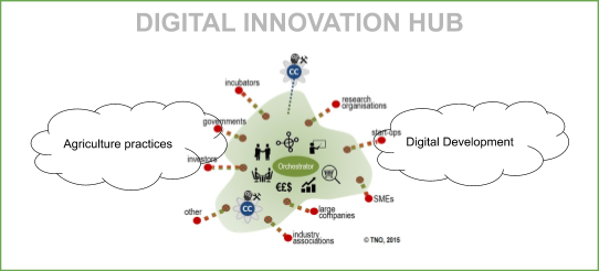
This challenge is prepared together by two projects SmartAgriHubs and PoliRural and four Digital Innovation Hubs will be included: SmartAfriHub  https://www.smartafrihub.com/home, PoliRural https://hub.polirural.eu/home, FOODIE SmartAgriHub https://www.agrihub.cz/home and http://dih.bosc.lv . The challenge will be part of both the Kampala INSPIRE hackathon https://www.plan4all.eu/kampala-inspire-hackathon-2020/ and Dubrovnik INSPIRE hackathon https://www.plan4all.eu/dubrovnik-inspire-hackathon-2020/.

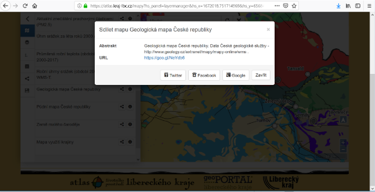
And also shared on social media


Yes, I want to register for Challenge #10!

Challenge 5: IoT 4 Africa

This is a description of Challenge No. 5 of the Kampala INSPIRE Hackathon 2020 led by Michal Kepka and Joel Muhanguzi – a local mentor from Africa.  For more information about mentors see the link.

Sensors are important producers of data for many domains of the daily life. Importance of this sensor data is growing with approach of IoT and availability of sensors. Typical domains are environmental monitoring, meteorological monitoring, agriculture, transport and logistics. Very often these specific domains use specific formats and interfaces to publish data.

The main goal of this challenge is to make a research on available sensor data, formats and standards used by local data producers and to select appropriate datasets to integrate them for further processing. Selected datasets can be integrated in open source data management solution we are developing for almost 10 years called SensLog. This web-based solution is using system of so-called Connectors to load sensor data from publishers where is no influence on the publishing data format. We are currently working on implementation of standardized interface based on the OGC SensorThingsAPI standard. This Connector should not only load data from services providing this standard, but publishing data by services defined in this standard as well.

Yes, I want to register for Challenge #5!

Challenge 8: Text Mining and Metadata

This is a description of Challenge No. 8 of the Kampala INSPIRE Hackathon 2020 led by Karel Charvat, Michal Kepka, Karel Panek, Marek Splichal and  Stepan Kafka.  For more information about mentors see the link.

To be possible to use any data, including geospatial as part of Digital Innovation Hub, it is necessary to be able to discover this data easily. For this purpose metadata catalogues are used, which can help describe and discover available data. In Kampala, INSPIRE hackathon, for example, Challenge 2: SmartAfriHub – Agriculture Digital Innovation Hub for Africa will offer a possibility to visualise map services and map composition.

To allow this, we need to have access to visualisation services and we need to discover these services. For this purpose, Challenge 8 will be focused  on collecting metadata describing spatial data in Africa. We will focus on metadata related to services, and formats, which could be used for online visualisation or access to data (WMS, WFS, WCS, KML, GeoJSON, ArcGIS services) We will try to use three possibilities how to collect metadata:

  • Harvest geospatial services from existing catalogues. It will be an automatic process, where selected metadata of open geospatial data can be harvested from another catalogue as FAO, UNEP, NextGEOSS or other national catalogues. The main task will be to recognised existing catalogues.
  • Manually publish metadata of selected services using URL of these services

  • The third part of this challenge is to discover the resources of Open Geospatial Data in Africa and publish this data source in the metadata catalogue using text mining methods. We will test text mining methods to discover potential data source addresses on Web pages.

Yes, I want to register for Challenge #8!

Challenge 4: Desert Locust

This is a description of Challenge No. 4 of the Kampala INSPIRE Hackathon 2020 led by Paul Kasoma, Kizito Odhiambo, Lilian Ndungu. For more information about mentors see the link.

Parts of Eastern Africa are experiencing locust infestation since the end of 2019 and it has posed to be a great threat to the East African Societies, these locusts can form swarms of billions of individuals that damage crops and pastures. Without timely or effective interventions, sporadic cases of desert locusts can easily turn into an upsurge and ultimately a plague. 

Previously, the UN warned that an imminent second hatch of the desert locusts could threaten the food security of 25 million people across the region. So far, East Africa society is losing a lot of Billions in controlling the spread of desert locusts. A lot of crops have been destroyed, revenues and export earnings have dropped as well as an increase in governments’ expenditure in trying to contain the outbreak. The appearance of the locusts follows a period of extreme weather, including devastating floods, that have further threatened the food supply. 

Desert locust plagues take over a year to materialize. Stages of plague development include:
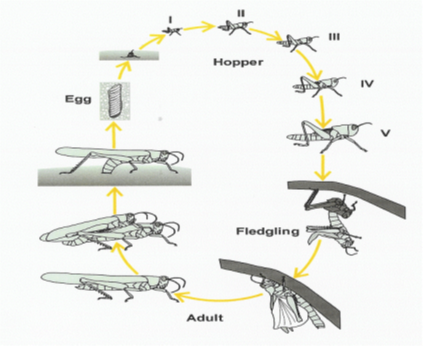
Picture 1. Illustration of Desert Locust life cycle
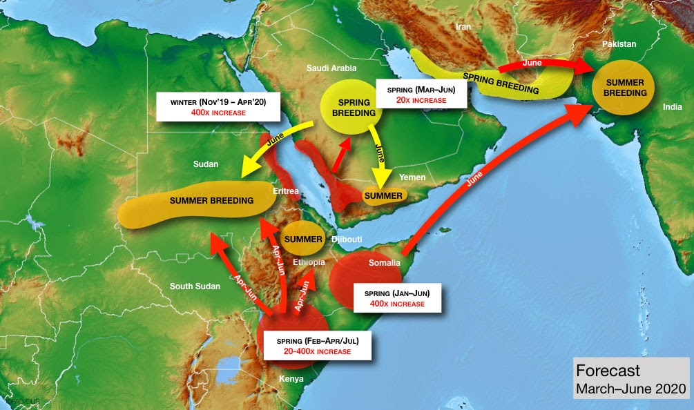
Stage 1: Outbreak. Small and localized, can affect the size of a small town, consisting of dispersed populations.

Stage 2: Upsurge. Large increase in locust numbers, usually 2-3 successive transient breeding seasons, can affect the size of a country.

Stage 3: Plague. Widespread (intraregional) and heavy infestation of locust bands and swarms after a year of good rains and uncontrolled upsurges, can affect the size of a continent.

All these stages are equally dangerous and need to be effectively contained. however, it’s so important to target the dormant stage in the circle, which is the eggs stage, once these are destroyed, all the other metamorphosis is eliminated thus avoiding its danger.

However, early detection is critical in locust management – in the outbreak phase before they form swarms – because they possess very high mobility in the latter state; it is difficult to control mass migrating insects. In case of an outbreak, an early warning system could help locust control centres better manage intervention efforts to prevent locust upsurges and the formation of large swarms. This preventive strategy needs information on potential predictors of desert locusts such as various weather and soil parameters including: rainfall, temperature, air pressure, wind and soil moisture as well as information on near-real-time vegetation that is becoming green, required for locust breeding and preferred by the insect. 

With such a variety of threats the locust imposes onto harvests and yields, there is no silver bullet to protect against losses and damage. Rather, a cohesive approach is needed that incorporates all available tools in the toolbox, from better forecasting and monitoring technologies to other innovative means that preserve human life, crop life, animal life as well as soil biodiversity.

Smallholder farmers are on the frontline when a pest outbreak takes hold. A small swarm of desert locusts can eat the equivalent food of 35,000 people per day, for example, while crop losses resulting from the spread of fall armyworm across sub-Saharan Africa are estimated to cost up to $6.1 billion a year. Yet while their livelihoods are most at risk, smallholders can also play a significant part in tackling crop pests like the desert locust.

By giving farmers access to better surveillance technology that enables them to monitor pests and forecast potential outbreaks, infestations can be tracked and managed effectively. Therefore, we invite innovative solutions for the control of the spread, breeding, as well as innovative early warnings solutions for the locusts outbreaks while preserving human, animal and soil life.


Picture 2: Desert Locust Risk (FAO)

To support local initiatives to monitor and control the locusts, this challenge will work towards developing a geospatial risk of outbreak model for the timely location of desert locust development and gregarization risk zones in Uganda. The challenge will take into account the presence or absence of transient phases of the desert locust species, biotope conditions, and gregarization thresholds for juveniles as well as flying adults. Part of the challenge will involve collating, summarizing and analysing field data (e.g., vegetation, rainfall, locust and control information) in order to assess the current situation and forecast the scale, timing and location of locust breeding and migration. 

Both vector data, such as administrative boundaries, and raster data, such as satellite imagery and rainfall estimates, will be combined to help better understand the spatial relationship between infestations and the local environment. Earth observation data will permit a more efficient monitoring of locust breeding and swarming areas, as well as forecasting and preventing upsurges and/or invasions of locusts. This will minimize the socio-economic and environmental impacts linked to locust control while reducing the field teams’ workload. This challenge adds spatial and temporal precision to the RAMSES platform, a FAO database used to monitor and report on the desert locust.

Therefore, we invite innovative solutions for the control of the spread, breeding, as well as innovative early warnings solutions for the locusts outbreaks while preserving human, animal and soil life.

Yes, I want to register for Challenge #4!

Continue reading

Challenge 6: Climate Change Trends for Africa

This is a description of Challenge No. 6 of the Kampala INSPIRE Hackathon 2020 led by Pavel Hájek, Jiří Valeš, Karel Jedlička, Samuel Ekwacu. For more information about mentors see the link.

This team aims to demonstrate several options for meteorological data exploitation for the needs of African farmers. The farmers’ needs were collected and are described in the Vaughan et al. (2017) study:

During previous INSPIRE Hackathons, we worked on an Agroclimatic map of a selected region, on a tool alerting farmers about forecasted severe weather conditions, or on a Climatic Services for Africa.

 The team has developed a concept service returning:

  • Growth plan – a time interval when to start planting to maximize yield
  • Nitrogen plan – a time interval when to insert nitrogen fertilisation to maximize its effect
  • Insect pests alert – alert when a risk of insect pest attack is high
    (Source: https://www.plan4all.eu/2019/04/team-2-progress-report-i/)

This challenge for Kampala INSPIRE Hackathon is to search for trends in climatic data because future climatic conditions can be inspected and potentially forecasted based on temporal trends in climatic data.

Therefore we plan to provide a proof of concept scenario in which a user enters coordinates (i.e. choose a locality), he/she will get information about several climatic variables (e. g. Last spring / First fall frost date, Annual/Seasonal Evapotranspiration and precipitation, Soil temperature, Solar radiation, etc.) and their evolvement in time. The initial visualization can be depicted by Figure 1 below, where an Annual average temperature and the trend of such a variable is shown (this figure is taken from Stargate project). More-over we would like to incorporate information about the uncertainty of such a variable in the graph as well, in order to capture the credibility of the used data.

Fig. 1 An example of a temperature variable and the visualization of its trend in Rostěnice farm, CZE. References: EUXDAT project and Stargate project.

Yes, I want to register for Challenge #6!

Challenge 9: Ethical and legal aspects of open data affecting farmers

This is a description of Challenge No. 9 of the Kampala INSPIRE Hackathon 2020 led by Foteini Zampati, Alice Namuli, Chris Addison . For more information about mentors see the link.

Open Data offers a great potential for innovations from which the agricultural sector can benefit decisively due to a wide range of possibilities for further use. However there are many inter-linked issues in the whole data value chain that affect the ability of farmers, especially the poorest and most vulnerable,  to access, use and harness the benefits of data and data-driven technologies.

The use of open data in agriculture is associated with some technical, ethical and legal challenges.  

The technical challenges are associated with the need to create and develop new standards, platforms and infrastructures to allow access and better use of the data according to FAIR principles. In the last couple of years, the use of open data has also raised  some ethical and legal issues as more and more stakeholders have entered into the agricultural sector developing new technologies that focus mainly on the collection, analysis and management of agricultural data. These ethical and legal aspects related to accessing and using data by the farmers and sharing farmers’ data have been less explored.

Smallholder farmers  face challenges due to a lack of trust and  transparency on issues such as data ownership, data rights, consent, data privacy, data security and definitional issues such as what data should be considered personal or not.  Moreover, the contracts and licensing agreements that currently govern data transactions are complex, leaving smallholder farmers with very little negotiating power.

We aim to identify gaps and address  ethical,legal and social challenges among other such as the digital divide. Our main objective is to develop a better understanding on ownership and control of agricultural data, data governance, explore the role and responsibilities of stakeholders in the data value chain. In addition we will highlight the often-complex legal issues related to open data in the areas of law, data rights,policies,codes of conduct, data protection, intellectual property rights, licensing contracts, traditional knowledge and personal privacy and finally do some recommendations and develop solutions through policy and legal frameworks to help ensure a fairer distribution of the benefits of open data, increasing motivation among actors involved in agriculture and nutrition, to use open data and make it more readily available.

Yes, I want to register for Challenge #9!

Challenge 7: EO4FoodSecurity


This is a description of challenge No. 7 of the Kampala INSPIRE Hackathon 2020 led by Karel Charvát, Jiri Kvapil, Dmitrij Kozuch, Hana Kubickova, Jan Chytry, Lilian Ndungu. For more information about mentors see the link.

EO4FoodSecurity challenge is supported by EO4Agri project http://www.eo4agri.eu/.

EO4AGRI main target is to prepare the European capacity for improvement of operational agricultural monitoring from local to global level based on information derived from Copernicus satellite observation data and through the exploitation of associated geospatial and socio-economic information services.

Thus, EO4AGRI enlarges and further systematizes knowledge about Copernicus for agriculture and identifies gaps in the utilisation of EO in AgriFood, public services and needs of financial sector, including international policy and coordination programmes.

    • EO4AGRI assists the implementation of the EU Common Agricultural Policy (CAP) with special attention on the CAP2020 reform, requirements of Paying Agencies and Integrated Administration and Control System (IACS) processes.
    • EO4AGRI works with farmers, farmer associations and agro-food industry on specifications of data-driven farming services. They focus on increasing the utilization of EC investments into Copernicus Data and Information Services (DIAS).
    • EO4AGRI addresses global food security challenges coordinated within the G20 Global Agricultural Monitoring Initiative (GEOGLAM) capitalizing on Copernicus Open Data as input.
    • EO4AGRI assesses information about land-use and agricultural service needs and offers to financial investors and insurances and the potential added value of fuelling those services with Copernicus information.

Challenge 7 will be focused on the third topic dedicated to Food security and mainly on EO and food security in Africa. There will be two Topics:

  • Ideation focused on the discussion of Potential of EO for Africa from point of view of African Stakeholders
  • Hackathon or Datathon with focus on testing different methods of automatic classification/interpretation of satellite images from Africa using cloud tools including AI.

Potential of EO for Africa

This part will be a continuation of the last year Nairobi INSPIRE Hackathon. There were identified next areas, where EO can help to African Agriculture:

Soil management can benefit a lot from earth observation. Modelling erosion would help avert loss in soil fertility.

  • Near real-time crop monitoring data would be very helpful to farmers, because it could enable them to identify remedies to crop failures in good time and avoid losses.
  • The same data could assist government plan in advance in terms of addressing the anticipated deficit in food stock hence avert cases of food shortage.
  • Earth Observation will also be very important in prediction analysis in the agricultural sector. This will permit African Agriculture to be economically and technically efficient. It can also permit African countries to specialise in different sectors, therefore, develop trade agreement..
  • In highlighting the suitable areas for different agricultural practices and the hotspots of food insecurity. As any other thematic area, agriculture has a geographic dimension that can only be captured and revealed by accurate and dynamic earth observation data.
  • Earth observation can be used to assess risks/threats to sensitive ecosystems like forests and wetlands. Forests and wetlands areas are known as contributors to food security, particularly when sustainably used.
  • EO in particular whether data and biomass can be used to generate index-based services for Banking and insurance such as Weather and Yield index 

During the virtual phase of Hackathon, we plan to discuss this issue and collect additional ideas. We will also discuss, how could be guarantee better access for African Comunity to EO related services.

Automatic classification/interpretation of satellite images from Africa using cloud tools including AI

Web-based JupyterHub environment exposing a set of powerful Python-based spatial data visualisation, analysis and manipulating tools. These are GeoPandas, eo-learn and many more allowing spatial and satellite imagery analysis, while using your web browser and working on a remote JupyterHub server.  Apart from that, set of other third-party tools is also available on the server- just mentioning some of them – GDAL, Orfeo Toolbox, GRASS, QGIS API, etc. Furthermore, users can even use custom developed data processing tools, visualisation tools and publication tools – mostly LayMan and SensLog. 

Layman is a tool to facilitate the management of spatial data, SensLog is focused on sensor data manipulation. Thanks to QGIS plugin, easy publication of map compositions as map services is available.

Sentinel 2 images of target locality will be available to Hackathon participants for satellite imagery classification workflows. Images are available in L2A level of processing, i.e. after atmospheric corrections that we have already calculated for your convenience.

Hackathon participants can utilize tools for unsupervised or supervised classifications using both statistical and neural network-based methods as well as the calculation of various vegetation or other indices, try to estimate the type of land cover, classify the type of crops, etc.

Images covering northern and eastern parts of Lake Victoria (36NVF, 36NWF, 36NXF, 36MXE and 36MXD – see below)

and Victoria Falls (35KLA, 35KMA and 35KNA) would be available to participants.


Sentinel 1 radar scenes would be also available for those who are seeking even more challenging challenge. These are not affected by clouds, however require much higher theoretical background and practical skills.

Yes, I want to register for Challenge #7!

Challenge 3: OpenLandUse for Africa

This is a description of Challenge No. 3 of the Kampala INSPIRE Hackathon 2020 led by Dmitrij Kozuch. For more information about Dmitrij see the link.

The main goal of the challenge is to do a research on available data sources, that could be used in defining the land use in Africa. That could be data about land cover, protected areas, urban areas, topographic geographic databases, transport infrastructure, points of interest, crowdsourced data etc.

After the research is done the algorithm how to define land use type based on the collected data will be created. As a result ideally the land use map of Africa will created.

As an additional extra tasks could be seen integrating the data into open-source solution SensLog (by implementing appropriate SensLogConnector), as well as extracting some important information (for example, about land cover) from satellite imagery.

The participants of the team will work on various tasks that could, depending on the interest, include:

  • Research on available data sources (about land use, land cover, borders of administrative regions/municipalities, topographic databases, protected areas etc…)
  • Collecting data (crowdsourcing, using satellite images to do automatic classification or manual tracing)
  • Working on integrating raster data sources into OpenLandUse dataset (for instance, some important datasets such as „South African National Land Cover“ , „S2 PROTOTYPE LAND COVER 20M MAP OF AFRICA 2016“ are available just in raster format, as well as results from automatic classification are typically available as rasters)
  • Exploring , wether Hierarchical INSPIRE Land Use Classification System(HILUCS) is a good classification system is suitable for Africa, and if not what is the better alternative.
  • Exploring how to define land use based on available data. Presumably it will be mostly data about land cover and its change available in raster format

In case of interest in one of those abovementioned tasks, please, don‘t hesitate to contact me at dmitrii@seznam.cz

lllustrational image – sample of „South African National Land Cover“ dataset, that was produced based on automatic classification of satellite imagery for the year 2018 and has spatial resolution 20 meters. Would be good to integrate it into the OpenLandUse for Africa dataset.

Yes, I want to register for Challenge #3!

Challenge 1: Transportation related aspects of Urban Planning – use case of Kampala

This is a description of Challenge No. 1 of the Kampala INSPIRE Hackathon 2020 led by Stephen Kalyesubula, Tuula Löytty, Daniel Beran and Karel Jedlička.

Transport industry is a point of concern because lately it’s costly to do business in Kampala due to traffic congestion which has resulted into prolonged travel times, environmental degradation and ultimately presents a disincentive to investors. 

https://commons.wikimedia.org/wiki/File:Nairobi_to_Cape_Town_09.jpg

Developing cities like Kampala have poor roads which are bumpy, potholed and sometimes non-laned with disorderly and chaotic complex traffic conditions characterized by a lot of braking and sometimes honking. Most of these roads are narrow, poorly planned and constructed and are non-laned or with only two lanes. Traffic congestion on these roads is caused by a heterogeneous mix of objects ranging from large carriers, small vehicles, motor bikes, pedestrians, hawkers and sometimes animals. With lack of real time information on traffic flows, traffic police officers fail to redirect traffic in order to avoid traffic jams, and travellers can not plan their journeys in advance in real time to avoid congested routes.

According to Kampala City Capital Authority, the additional number of masses travel from the metropolitan area to either work or transact businesses and majority of them use taxis and boda-boda as the only public means of transport. Therefore, the increased number of masses put pressure on the available means of transport, causing shortage of transport services.

The ideal is to select various traffic nodes of interest in the capital of Kampala and

  • Use a traffic modeller tool to test various traffic scenarios together with  https://trafficmodeller.com/
  • Routing with GIS: Using GIS to provide alternative routes to road users so that they don’t get in any congestion on the road using any selected traffic nodes.  

Expected outcomes of the team members’ and mentors’ common efforts are: 

  • The use and reflection of the tools (traffic modeller + routing)
  • A concept and methodology to use the geospatial IT- solutions on traffic management in Kampala
  • Something surprising and unexpected

Yes, I want to register for Challenge #1!

Challenge 2: SmartAfriHub – Agriculture Digital Innovation Hub for Africa

This is a description of Challenge No. 2 of the Kampala INSPIRE Hackathon 2020 led by Jiří Kvapil, Emmanuel Okalany, Maureen Agena, David Martin Amitu, Francis Otto and Jacob Kato from Regional Universities Forum for Capacity Building in Agriculture (RUFORUM) based at Makerere University in Kampala, Uganda, Petr Uhlir, Tuula Löytty, Dimitrij Kozuch, Filip Leitner, Jan Vrobel.

Digital Innovation Hubs (DIH) are multi-actor ecosystems that support farming communities in their digital transformation by providing a broad variety of services from a one-stop shop. DIHs purpose is to 

  • provide a social space for community of practices; 
  • provide access to digital technologies and competencies;
  • provide access to infrastructure and tests digital innovations (“test before invest”);
  • provide development playground for map based projects;
  • offer training and skills development;
  • offer support in finding finance for digital transformation;
  • help in networking and connecting users and suppliers of digital innovations.

SmartAfriHub (https://www.smartafrihub.com/) was developed and launched at Nairobi INSPIRE Hackathon 2019 to support the knowledge transfer and innovation between the ICT, farming communities and public bodies in Africa. 

The aim is to bring together IT suppliers, the farming sector, technology experts, investors, science and technology, public bodies, and other relevant actors to understand and solve real life problems and challenges of the African farmers.  SmartAfriHub supports the development of African Agriculture Knowledge and Innovation System regionally and nationally. 

The challenge 2 invites user groups to a dialogue and to explore, experiment and reflect the features and applications of the Digital Innovation Hub.  The two entwined challenges of the team 2 are: 

  • Develop tactics on how communities of practices of agriculture and digital technologies could “seek, sense and share” needs, problems and knowledge at SmartAfriHub and deliver value to community members, farmers and society of Uganda. Such agriculture community of practice is for example RUFORUM (www.ruforum.org), and digital community of practice is Plan4all, (www.plan4all.eu). The available tools in hub are for example Blog, Wiki, Forum, Library and Science Shop.
  • Explore and test the available SmartAfriHub applications with the help of a mentor. For example one can develop a map of your own with one or several layers. Spatial data focused on agriculture, Earth Observation (Sentinel 2 and/or others) and other open spatial data can also be integrated in the map viewer. The available tools are HSlayers NG and Layman. No expert skills are required, however basic orientation in GIS technologies and spatial data principles is very welcome.

Expected outcomes of the team members’ and mentors’ common efforts are: 

  • to reach out agriculture and digital communities of practice 
  • to reach out individual explorers, developers, innovators, scientist, researchers etc. 
  • to improve awareness of existence, purpose,features and tools of SmartAfriHub
  • to multiply the number of subscribers of SmartAfriHub
  • to multiply the number of visits at SmartAfriHub
  • to run work-based learning to test SmartAfriHub applications and deliver outputs
  • to enjoy learning, co-creation and innovativeness at social virtual space 
  • to provide platform for networking 
  • to extend participants’ personal network

Yes, I want to register for Challenge #2!